 Print-Friendly Version Print-Friendly Version
|
|
Foothills Trail 77 Thru-Hike | |||||||
| The Basics: | |||||||
| STATUS: | Cancelled - Hide from Calendar | ||||||
| Event Type: | Backpacking | ||||||
| Event Location: |
Table Rock State Park


| ||||||
| Date(s) & Time: | Wed, Jan 1 2003 6:00 am >> Sun, Jan 19 2020 6:00 pm (Carpool Departure: 6:00 am *log in for location*) | ||||||
| Registration Opens: | Thu, Dec 19 2019 9:30 pm | ||||||
| Registration Cut Off: | Fri, Dec 20 2019 9:30 pm | ||||||
| Event Duration: | 3 Days 12 Hours | ||||||
| Difficulty Rating: | D7: Extreme (Exploratory) | ||||||
| Distance: | 77 Miles | ||||||
| Pace: | Fast | ||||||
| Trip Leader(s): | Horhay Email Trip Leader(s) Email Trip Leader(s)
You must be logged in to get the Trip Leader contact information. | ||||||
| Member Cost: | None | ||||||
| Participant Info: | |||||||
| Who's Invited: | Members Only, 21 And Older Only | ||||||
| Maximum Group Size: | 4 | ||||||
| Minimum Group Size: | 2 | ||||||
| Number Registered So Far: | 1 / 0 (To see who's signed up, log in to the Member Area) | ||||||
| Are Dogs Permitted: | No | ||||||
|
Note: This is an "EXPLORATORY" trip. This means that there are parts of this trip, or perhaps the whole trip, that is new to your Trip Leader(s). However, they are confident that this will not be an issue. This note is here so that you can make an informed decision. When a Trip Leader isn't personally familiar with a trip, there is an increased chance of things not going as planned and you need to be prepared. The Trip Leader may have additional details in the itinerary. | |||||||
| Itinerary: | |||||||
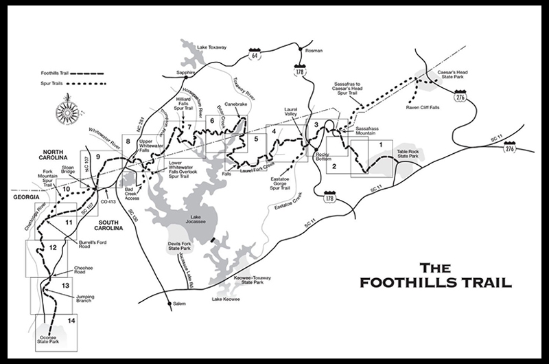
Take a day or two off and come join me for a self-supported, winter backpacking thru-hike of the glorious FOOTHILLS TRAIL. We'll be kicking off early Thursday to get a jump on local traffic and to get the cars shuttled to the end points (unless we arrange a shuttle). Once set: Table Rock State Park is where we'll kick off headed in a westerly direction to Oconee State Park. Divided up into 4 uneven days to match the uneven approximate 17,500 feet of elevation and 77 miles we plan to test you to see if you got what it takes: DAY 1: Hauling arse from the carpool lot to TRSP and set up for the shuttle so we'll get on the trail as soon as humanly possible is critical. We have a lot of steep terrain today - Pinnacle and Sassafras Mountain greet us with an alomst all uphill beginning to the day. The plan is to be backpacking quckly so we reach our projected mileage goal b4 sunset (hopefully it's not that late). Gather water and gear up for a big day on Friday! We'll get dinner rolling and get food in bearbags and stowed b4 hunkering down for the night. I don't plan on hanging around any fires this trip, but if someone feels they have the energy for that...more power to them. DAY 2: A LONG day awaits and an early alarm will be set to get the full kick of a 26 mile day with weight on its way. Not exactly sure what time that alarm will go off but rest assured it will probably be dark when we roll out. Along the way there's absolutely amazing winter scenery and finding water along the way should not be a problem. A quick lunch stop may take place in a scenic locale, but most of the snacks will be consumed on the fly. What a day...once we're setting up for the night, it will be much of the same...water gathering, inhaling calories, hanging bearbags and catching Zzz'z. DAY 3: Well, today is another long day, an almost mirror image of Friday. The schedule will be planned according to how we're feeling as far as a wake up call, but planning another early start to be sure we get the necessary miles in. That way we we're set for a short day on Sunday. A majority of the day has more elevation loss than gain, so we'll be testing the toe boxes out on our boots/shoes...and of course we'll have a bit more wiggle room today so we'll be shootin' from the hip on a lunch stop and breaks. Set up for the night will be depend on how far and how strong we're feeling for Sunday, but I'd like to be sure it's less than 10 to get out on Sunday...so as we set up for sleep on the last full day we can be sure to replace those calories and get ready to hit the rack for some much needed sleep. DAY 4: We're outta here gang! So hopefully we're set on schedule for less than a 10-miler to Oconee State Park and gather the other car(s) at TRSP and head out. No trail lunch stop planned today, just business as usual...but I might need an adult beverage or two after kicking frozen dirt for 77 miles...so here's to the E-W thru hike of the FOOTHILLS TRAIL. The elevation map below Magenta - Day 1. Red - Day 2. Blue - Day 3. Green - Day4: Each day has "estimated" miles shown...not to scale, not in stone. Most of us (including myself) have the national holiday off on Monday, the glorious Martin Luther King, Jr. Day...so if the "fit hits the shan" on one of those days we might have a little wiggle room. That is a LAST RESORT and I do not consider that as the plan...a back up yes, but I tend to rather lead my "DAY ON, NOT A DAY OFF HIKE" in Roswell. That is the plan...if you're down with it..let do it!
Lunch at Habanero's is a highly suggested option b4 heading home, hence the short day ;) *denotes approximate distances, don't get feelings hurt if we extend mileage or cut things short. There has been a couple of bridges that have been destroyed from recent storms (written up originally in Spring of '19), so water crossings are possible - having an open mind is probably a great thing. Self-shuttle could be possible if we get two people willing to drive, otherwise I have some ph#'s for local shuttle services...that detail may involve some cost sharing, but we know more as the event approaches...if you can drive, please let me kow at the time of sign up.
| |||||||
| |||||||
| How to Get There: | |||||||
| Event Directions: | TABLE ROCK STATE PARK Just #GTS :) | ||||||
| Carpool to Event Distance (round trip): | 300Mile(s) | ||||||
| Carpool Departure Time: | 6:00 am | ||||||
| Carpool Location: | Log in for location | ||||||
| Carpool Directions: | Log in for directions | ||||||
| Carpool Cost: | Estimated cost per vehicle for this event is $120.00 using a reimbursement rate guideline of $0.400 per mile. The total amount should be divided by the number of people in the vehicle, including the driver. This is a guideline, not a rule, for drivers but the cost should not be higher unless there are extenuating circumstances. | ||||||
| Notes: | |||||||
|
ABFE #WinterBackpacking #NoTICKS
* We encourage all members to follow our Etiquette Guidelines while participating in AOC events. | |||||||
Cancellation/Partial Attendance: Please review the AOC cancellation policy. | |||||||
 Calendar of Events
 Event Places
