 Print-Friendly Version Print-Friendly Version
|
|
Cohutta Mountain Loop Hike | |||||||
| The Basics: | |||||||
| Event Type: | Hike | ||||||
| Event Location: |
Cohutta Wilderness Area


| ||||||
| Date(s) & Time: | Sat, Jul 13 2019 6:30 am >> Sat, Jul 13 2019 6:30 pm (Carpool Departure: 6:30 am *log in for location*) | ||||||
| Registration Opens: | Mon, Jul 1 2019 8:00 pm | ||||||
| Registration Cut Off: | Thu, Jul 11 2019 8:00 am | ||||||
| Event Duration: | 12 Hours | ||||||
| Difficulty Rating: | D6: Advanced | ||||||
| Distance: | 16 Miles | ||||||
| Pace: | Moderate | ||||||
| Trip Leader(s): | Chuck R Email Trip Leader(s) Email Trip Leader(s)
You must be logged in to get the Trip Leader contact information. | ||||||
| Member Cost: | None | ||||||
| Participant Info: | |||||||
| Who's Invited: | Members Only, 21 And Older Only | ||||||
| Maximum Group Size: | 8 | ||||||
| Minimum Group Size: | 2 | ||||||
| Number Registered So Far: | 10 / 0 (To see who's signed up, log in to the Member Area) | ||||||
| Are Dogs Permitted: | No | ||||||
| Itinerary: | |||||||
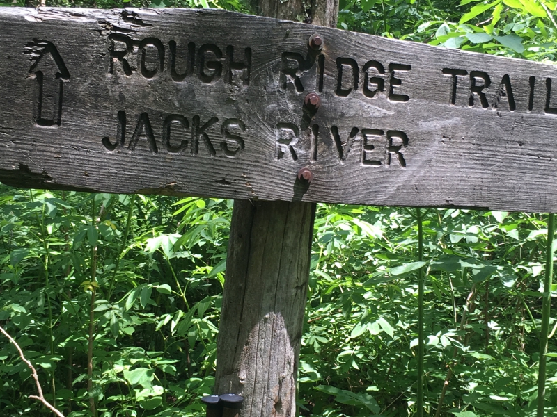
| Please do not sign up if you do not have any recent D-6 Wilderness hikes with the A.O.C. ( preferably you have hiked with me before) THIS IS NOT A SWIM HIKE! This trail will have its moments. We will park at the 3 Forks Trailhead (3,790 elevation ) in The Cohutta Wilderness. Our hike will direct us north on East Cowpen Trail for around 4.5miles. We will reach the junction of Hickory Ridge Trail ( Buckeye Mountain (3,500 elevation) for our break. After rest our trail will be descending north for around 3.6 miles to Beech Bottom and a river ford (Jack's River 2,200) for lunch and a cool down. When lunch is resolved we go southeast (Jacks River Trail) for a short distance on another river ford (Jack's River) to the Rough Ridge Trail. Leaving your water shoes on for another short distance we will ford Rough Creek. When the boots are back on we will hike the Rough Ridge Trail out for around 7.4 miles back. (we will have a good climb for the beginning 3 miles) We hike to the East Cowpen Trail turning left and then we will go around 0.7mile to 3 Forks trailhead to finish the clockwise Loop! In summary, this 16 mile Loop will have 4 connecting Trails, 3 Fords, Blow downs, and narrowing unbeaten Trails ( foot paths). Rough Ridge is one of the least used trails in the Cohutta Wilderness! I see Bears every time I'm out there - other people do too! There are all kinds of snakes, Moccasins around the River and Rattle Snakes in the hills! Copperheads will be on all trails. We may get lucky and only see Indigo Racers or a Southern black racer. I'm looking for hikers who can adapt to these uncertain conditions. It's still summer so it will be hot. Be honest with yourself about whether you have the physical ability and desire to do this event. If you sign up and I do not know your hiking ability, I will contact you to find out if I believe you are a good candidate for this trip. I reserve the right to remove any member from this trip, who in my opinion, may not have the physical ability to keep up with the group. Total Mountain Travel is approximately 4,150. There will be a bathroom stop going up at Ingles just before Ellijay - they also have a Starbucks. ( please no audible music or tree climbing). Let nature be the sounds. | |||||||
| |||||||
| How to Get There: | |||||||
| Event Directions: | Three Forks Parking Area Coordinates are 34.8815613, -84.5658722 Directions: From Atlanta, GA: Take I-75 to I-575, and follow I- 575 up into North Georgia. I-575 will become Route 515. In Elijay, take a left onto Soule Bridge, and immediately another left onto GA Route 52. In downtown Elijay, take the second exit to the right on the roundabout. Follow GA 52 for 5.2 miles until Gates Chapel Road. Turn right onto Gates Chapel Road and follow it for 5.4 miles. When pavement will end, keep right onto Wilderness Trl. Follow it for 1.5 miles, and then take a right onto Old CCC Camp Road. Follow it for 3.2 miles to the top of the mountain and USFS 64. Turn right onto USFS 64, and follow it for 4.2 miles until you will see a large parking lot on the left of the road, while the road itself sharply switchbacks to the right. This is Three Forks. | ||||||
| Carpool to Event Distance (round trip): | 150Mile(s) | ||||||
| Carpool Departure Time: | 6:30 am | ||||||
| Carpool Location: | Log in for location | ||||||
| Carpool Directions: | Log in for directions | ||||||
| Carpool Cost: | Estimated cost per vehicle for this event is $60.00 using a reimbursement rate guideline of $0.400 per mile. The total amount should be divided by the number of people in the vehicle, including the driver. This is a guideline, not a rule, for drivers but the cost should not be higher unless there are extenuating circumstances. | ||||||
| Notes: | |||||||
|
Will hike in rain if weather allows. Plenty of carpool drivers needed.
Allow nature to be the sounds.🙏 * We encourage all members to follow our Etiquette Guidelines while participating in AOC events. | |||||||
Cancellation/Partial Attendance: Please review the AOC cancellation policy. | |||||||
 Calendar of Events
 Event Places