 Print-Friendly Version Print-Friendly Version
|
|
Arkaquah Trail to Brasstown Bald | |||||||
| The Basics: | |||||||
| Event Type: | Hike | ||||||
| Event Location: | Near Young Harris GA | ||||||
| Date(s) & Time: | Sun, Sep 6 2009 9:00 am >> N/A (Carpool Departure: 7:00 am *log in for location*) | ||||||
| Registration Opens: | Sat, Apr 18 2009 12:00 am | ||||||
| Registration Cut Off: | Sat, Sep 5 2009 11:55 pm | ||||||
| Event Duration: | Eleven hours, six and a half hours hiking, four and a half hours driving | ||||||
| Difficulty Rating: | D5: Difficult | ||||||
| Trip Leader(s): | John Weatherman Tom Jarosz  Email Trip Leader(s) Email Trip Leader(s)
You must be logged in to get the Trip Leader contact information. | ||||||
| Member Cost: | None | ||||||
| Participant Info: | |||||||
| Who's Invited: | Members Only, 21 And Older Only | ||||||
| Maximum Group Size: | 20 | ||||||
| Minimum Group Size: | 4 | ||||||
| Number Registered So Far: | 20 / 0 (To see who's signed up, log in to the Member Area) | ||||||
| Are Dogs Permitted: | Yes | ||||||
| Itinerary: | |||||||
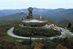
| This is a 12-mile strenuous hike. Do not attempt this hike unless you have successfully completed a long hike in the past with a lot of elevation gain. It used to be said the Arkaquah Trail was the second hardest trail in Georgia. Now that the Coosa has been rerouted and made easier, is Arkaquah now the hardest? You be the judge. We start at 2280 feet, go up and down 6.1 miles to 4784 feet to the top of Brasstown Bald, the highest peak in Georgia, and then we come back down the same way. This trail is notorious for its long steep initial climb to gain the ridge crest. We then follow the ridge as it undulates up and down but ever upward to the top. There are great views along the way with some light scrambling in one spot. Once we get to the parking lot at the top, we will take the half mile paved trail to the summit along with the tourists who drive up. There is a museum and a 360-degree observation deck on very top. If it is clear, we will be able to see four states. Please Note: | |||||||
| |||||||
| How to Get There: | |||||||
| Event Directions: | Directions to Track Rock Gap (Arkaquah Trailhead) Take 575 going north. Follow this all the way thru Jasper, Ellijay, Blue Ridge and Blairsville. The road designation will change as you go, being variously, I-575, GA-5, GA-515, GA-2 and US 76. Regardless of that, just stay on it, and follow the signs to Blairsville. Pit stop at the Blairsville Burger King on the right. About six miles past Blairsville, turn right onto Track Rock Gap Rd. Take this about two miles to the high point on the road. This is Track Rock Gap. The trailhead parking is on the right. It is also parking for the Track Rock Gap Archeological Area, and there should be signs for that. | ||||||
| Carpool to Event Distance (round trip): | 202Mile(s) | ||||||
| Carpool Departure Time: | 7:00 am | ||||||
| Carpool Location: | Log in for location | ||||||
| Carpool Directions: | Log in for directions | ||||||
| Carpool Cost: | Estimated cost per vehicle for this event is $80.80 using a reimbursement rate guideline of $0.400 per mile. The total amount should be divided by the number of people in the vehicle, including the driver. This is a guideline, not a rule, for drivers but the cost should not be higher unless there are extenuating circumstances. | ||||||
| Notes: | |||||||
|
* We encourage all members to follow our Etiquette Guidelines while participating in AOC events. | |||||||
| Cost Includes: | Please share gas expenses with carpool drivers. | ||||||
Cancellation/Partial Attendance: Please review the AOC cancellation policy. | |||||||
 Calendar of Events
 Event Places