 Print-Friendly Version Print-Friendly Version
|
Intrenchment Creek Park--Second AOC Visit!! | |||||||
| The Basics: | |||||||
| Event Type: | Hike | ||||||
| Event Location: |
South River Trail Intrenchment Creek Trailhead


| ||||||
| Date(s) & Time: | Sat, Jan 25 2020 10:00 am >> Sat, Jan 25 2020 12:00 pm | ||||||
| Registration Opens: | Tue, Jan 14 2020 6:09 pm | ||||||
| Registration Cut Off: | Sat, Jan 25 2020 8:00 am | ||||||
| Event Duration: | 2 Hours | ||||||
| Difficulty Rating: | D2: Easy to Moderate | ||||||
| Distance: | 5 Miles | ||||||
| Pace: | Moderate | ||||||
| Trip Leader(s): | Allen D Joyce T.  Email Trip Leader(s) Email Trip Leader(s)
You must be logged in to get the Trip Leader contact information. | ||||||
| Member Cost: | None | ||||||
| Participant Info: | |||||||
| Who's Invited: | Members Only, 21 And Older Only | ||||||
| Maximum Group Size: | 20 | ||||||
| Minimum Group Size: | 3 | ||||||
| Number Registered So Far: | 19 / 0 (To see who's signed up, log in to the Member Area) | ||||||
| Are Dogs Permitted: | Yes | ||||||
| Itinerary: | |||||||
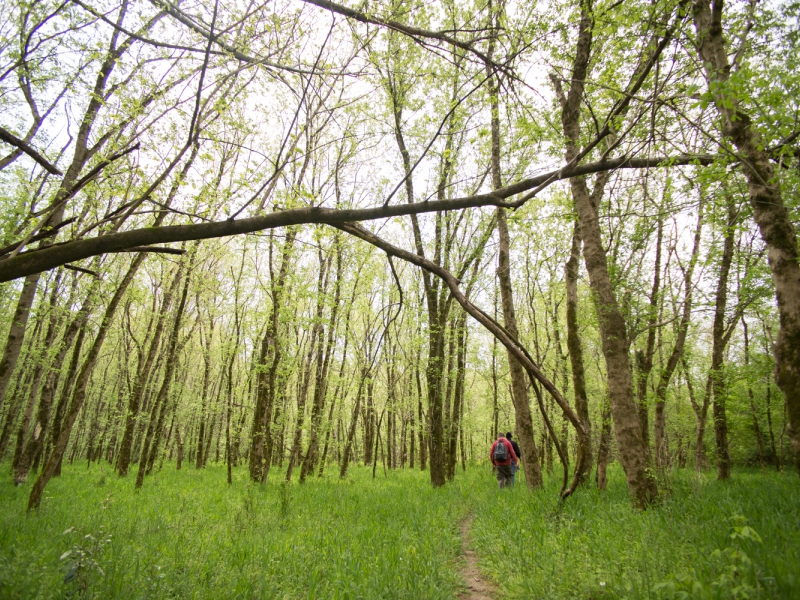
Come join the second ever AOC hike in Intrenchment Creek Park (ICP), a relatively new and undeveloped park in southeast DeKalb County. We will ramble around the flat trails of the former Atlanta Honor Farm, a minimum security facility, still owned by the City of Atlanta. We will wind our way around the area, getting in about 5 miles as we see the sights. Beginning hikers are welcome who are comfortable with steady walking for 2 hours, and exploring. Please note: the whole group stays together, so liesurely hikers will slow it down and are requested to attend other events, and request them if so desired. Your AOC trip leaders are eager to please! The trails are well worn, no rocks, and unmarked. Creek crossing is on stepping stones, no bridge, and easy to hop across. You may get your feet wet if the creek is high. If the creek is really high, we will skip the crossing and remain in ICP. The park was created "in perpetuity" by the Blank Foundation and given to DeKalb County. It has a pine plantation, riparian woods, and an RC airplane airport. Across the creek you might see ruins of the old prison farm, two ponds, old orchards, and some stone edifices from the Carnegie Library which was torn down decades ago. More pictures HERE. Originally, the land was purchased by the US government during WW I for a prisoner of war camp, but never used. It was converted into a prison farm which cleared almost the entire property, drained the floodplain, and was active into the second half of the 20th century. All the woods, except for a few sentinel trees, have grown up since then. We will walk by a grand Oak in the flood plain that was not cleared, and several magnificent trees. ICP trail Map aerial photo Drone video of Atlanta Prison Farm, and showing different forest types, mostly on the W side of the creek. The park is on the E side of the creek. The trailhead is in the pine forest in the distant left background of the opening panorama. Old Atlanta Prison Farm Map (aerial photo) | |||||||
| |||||||
| How to Get There: | |||||||
| Event Directions: | South River Intrenchment Creek Park Trailhead From the North and West, Take I-20 E to Flat Shoals Rd in DeKalb County. Take exit 62 from I-20 E LEFT on Flat Shoals over I-20 RIGHT immediately on Fayetteville Road. Follow 0.8 miles to next light STRAIGHT through intersection and the road becomes Bouldercrest. Take Bouldercrest Dr SE 2.1 Miles When Bouldercrest bends to left, go STRAIGHT onto West Side Pl ENTRANCE on RIGHT FROM the East and South: Follow I-285 to Bouldercrest Rd. Take exit 51 from I-285 Turn North, and Follow Bouldercrest Rd and Constitution Rd SE to West Side Pl Pass by Hardee's (on the right in 0.2 mi) 0.5 mi Continue STRAIGHT onto Constitution Rd SE 0.4 mi Turn RIGHT onto West Side Pl ENTRANCE WILL BE ON LEFT | ||||||
| Notes: | |||||||
|
NOTE: You can also pick up 6 miles of the PATH system South River Trail at this parking lot. It takes you through the woods all the way to GA State University Perimeter campus via the Michelle Obama Trail. Almost no one is on this trail, which may someday connect to the Beltline and Panola Mountain Trail system. URGENT: The park is the only hiking area in South Atlanta between Sweetwater Creek SP and Panola Mountain, and it is already threatened by a land swap that county commissioners are leaning toward approving. A growing movie studio across the street was offered expansion land by a county official, and you may wonder if this is appropriate. Is it worth it to sprawl into a last green space because a studio won't expand on existing developed land? A short video describes the park and the struggle. In the long run, the Park may grow into the old honor farm and a few dedicated citizens are hoping to save it. Further, it is part of an extended vision of green space that might include Constitution Lakes and the Dolls Head trail, among other loosely protected plots. More voices and hands needed for this important green space. The South River Watershed Alliance is stewarding this vision. This vulnerable land is in the situation of Chattahoochee parks before they became a National Recreation Area. Other large tracts in the area are getting bulldozed. Let us act together to protect the remaining few! * We encourage all members to follow our Etiquette Guidelines while participating in AOC events. | |||||||
Cancellation/Partial Attendance: Please review the AOC cancellation policy. | |||||||
 Calendar of Events
 Event Places
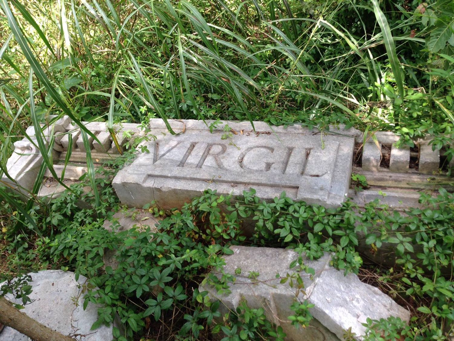