 Print-Friendly Version Print-Friendly Version
|
|
Three Forks Loop and Long Creek Falls | |||||||
| The Basics: | |||||||
| Event Type: | Hike | ||||||
| Event Location: |
Three Forks Trailhead (near Springer Mountain)


| ||||||
| Date(s) & Time: | Fri, Feb 28 2020 7:30 am >> Fri, Feb 28 2020 4:30 pm (Carpool Departure: 7:30 am *log in for location*) | ||||||
| Registration Opens: | Tue, Feb 25 2020 6:00 pm | ||||||
| Registration Cut Off: | Fri, Feb 28 2020 8:00 pm | ||||||
| Event Duration: | 9 Hours | ||||||
| Difficulty Rating: | D4: Moderate to Difficult | ||||||
| Distance: | 9 Miles | ||||||
| Pace: | Moderate | ||||||
| Trip Leader(s): | Holt Ward Email Trip Leader(s) Email Trip Leader(s)
You must be logged in to get the Trip Leader contact information. | ||||||
| Member Cost: | None | ||||||
| Participant Info: | |||||||
| Who's Invited: | Members Only, 21 And Older Only | ||||||
| Maximum Group Size: | 10 | ||||||
| Minimum Group Size: | 2 | ||||||
| Number Registered So Far: | 10 / 0 (To see who's signed up, log in to the Member Area) | ||||||
| Are Dogs Permitted: | Yes | ||||||
| Itinerary: | |||||||
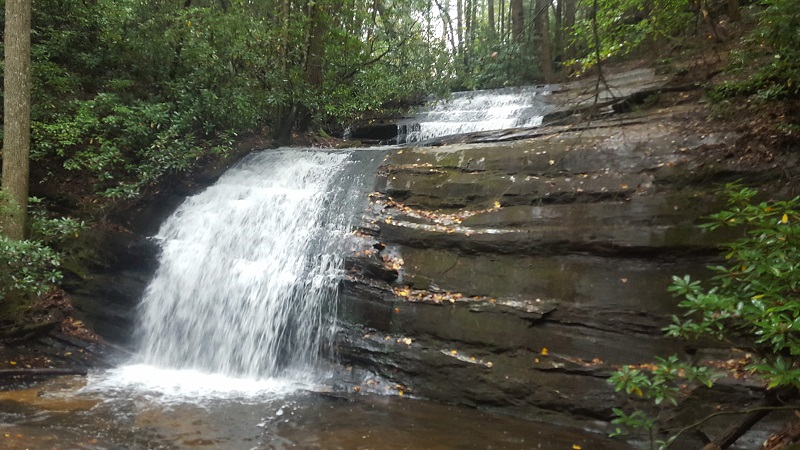
Have you ever wanted to hike some of the famous Appalachian Trail or Benton Mackaye Trail in North Georgia? Perhaps visit a wilderness waterfall? Well you are in luck if the answer is yes as we will accomplish all three of those things on this hike. Join me for this 9 mile hike which starts at the Three Forks trailhead north of Springer Mountain. Three Forks is where three streams (the Chester Creek, Stover Creek and Long Creek ) meet to form the Noontoola Creek. The trailhead is located on the side of USFS road 58. To start, we will cross a footbridge over Chester Creek and begin following the famous Appalachian Trail (or AT) south. The AT is a 2192 mile trail which begins at nearby Springer Mountain GA and ends on the summit of Mt Katahdin in Maine. For our hike, we will of course only be covering a small portion of this famous trail. For much of the first part of our hike, we will be closely following Stover Creek flowing along the base of Rich Mountain. Several times along the way we will intersect with the not as famous little brother to the AT, the Benton Mackaye Trail (or BMT). The BMT is a 300 mile “long trail” which also begins at Springer Mountain and ends at Big Creek at the northern end of the Great Smoky Mountains National Park in North Carolina. At the 3rd such intersection of the two trails, we will leave the AT and follow the BMT back north towards Three Forks. The BMT is an interesting contrast to the AT in that it gets far less foot traffic and is at least in this part of GA, a bit wilder and more rustic than the AT. Thousands of thru hikers begin their AT trek each year in GA, few of them will finish so the first miles of the trail in GA take a beating. Don’t get me wrong, it's still a very beautiful trail but the contrast with the BMT is interesting. At the 7 mile mark of our hike, we will pass through Three Forks again and have access to our cars if need be. Then begins the final phase of our trek, an out and back to Long Creek Falls. We will follow the conjoined AT and BMT at they head north following along Long Creek. After a one mile hike we will reach a point where the AT and BMT split for the last time until reaching the north end of the Smokies, some 300 trail miles away. At the split, there is a short trail which takes you to the base of the Long Creek falls, a beautiful waterfall with plenty of places to sit and take in its beauty. It is here that we will eat our lunch before backtracking on the trail one mile back to our cars and depart. In total, we will cover about 9 miles and 1600 feet of elevation along the way. Suitability: This is not a beginner hike. You should have some D4 or solid D3 experience in your history before signing up for this hike. If in doubt, please contact the Trip Leader to discuss the suitability for this hike.
(Carpool Information) We will be departing from the Busbee Drive Park and Ride parking lot a little after 7:30am. Directions to the car pool are listed below. The trip from the car pool location to Three Forks is about 1:45 hours. We will plan on finishing our hike no later than 2:30PM which will allow us to return to the Busbee park and ride by no later than 4:30pm (and hopefully sooner) I do not recommend that people drive to the trailhead directly unless they have been there before. The route there is a bit tricky with some confusing intersections and will include about 5 miles of gravel/dirt forest service roads. If you prefer to drive yourself, I strongly suggest you meet at the car pool location and caravan with us to Three Forks. | |||||||
| |||||||
| How to Get There: | |||||||
| Event Directions: | Directions to Three Forks Trailhead from Car pool location Coordinates (34.663559, -84.184082)
| ||||||
| Carpool to Event Distance (round trip): | 158Mile(s) | ||||||
| Carpool Departure Time: | 7:30 am | ||||||
| Carpool Location: | Log in for location | ||||||
| Carpool Directions: | Log in for directions | ||||||
| Carpool Cost: | Estimated cost per vehicle for this event is $63.20 using a reimbursement rate guideline of $0.400 per mile. The total amount should be divided by the number of people in the vehicle, including the driver. This is a guideline, not a rule, for drivers but the cost should not be higher unless there are extenuating circumstances. | ||||||
| Notes: | |||||||
|
* We encourage all members to follow our Etiquette Guidelines while participating in AOC events. | |||||||
Cancellation/Partial Attendance: Please review the AOC cancellation policy. | |||||||
 Calendar of Events
 Event Places