 Print-Friendly Version Print-Friendly Version
|
|
Summit GA's Highest Peaks: #1 - Brasstown Bald (4784') (via Wagon Train Trail) | |||||||
| The Basics: | |||||||
| Event Type: | Hike | ||||||
| Event Location: | Young Harris, GA | ||||||
| Date(s) & Time: | Sat, Mar 27 2010 8:45 am >> N/A (Carpool Departure: 9:00 am *log in for location*) | ||||||
| Registration Opens: | Mon, Jan 11 2010 9:30 pm | ||||||
| Registration Cut Off: | Fri, Mar 26 2010 8:00 pm | ||||||
| Event Duration: | per itinerary | ||||||
| Difficulty Rating: | D5: Difficult | ||||||
| Trip Leader(s): | John Weatherman Email Trip Leader(s) Email Trip Leader(s)
You must be logged in to get the Trip Leader contact information. | ||||||
| Member Cost: | None | ||||||
| Participant Info: | |||||||
| Who's Invited: | Members Only, 21 And Older Only | ||||||
| Maximum Group Size: | 16 | ||||||
| Minimum Group Size: | 4 | ||||||
| Number Registered So Far: | 12 / 0 (To see who's signed up, log in to the Member Area) | ||||||
| Are Dogs Permitted: | No | ||||||
| Itinerary: | |||||||
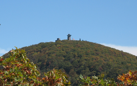
The North Georgia mountains may not be the Rockies (or the Himalayas), but they include many peaks that make for superb hiking and offer incredible views. For this series, we are counting down the tallest mountains in GA. #1 - Brasstown BaldBrasstown Bald is the tallest mtn in GA with an elevation of 4784' above sea level and a clean prominence of 2107'. The view from the observation platform is definitely one of the finest in the state...you can see most all of the other highest mtns in GA as well as into NC, TN, and SC.  PLEASE NOTE: If you have not very recently completed some tough AOC hikes, we will be contacting you to determine your level of fitness and experience and if this is the right hike for you. | |||||||
| |||||||
| How to Get There: | |||||||
| Event Directions: | Directions Young Harris College (Wagon Train Trailhead) | ||||||
| Carpool to Event Distance (round trip): | 202Mile(s) | ||||||
| Carpool Departure Time: | 9:00 am | ||||||
| Carpool Location: | Log in for location | ||||||
| Carpool Directions: | Log in for directions | ||||||
| Carpool Cost: | Estimated cost per vehicle for this event is $80.80 using a reimbursement rate guideline of $0.400 per mile. The total amount should be divided by the number of people in the vehicle, including the driver. This is a guideline, not a rule, for drivers but the cost should not be higher unless there are extenuating circumstances. | ||||||
| Notes: | |||||||
|
* We encourage all members to follow our Etiquette Guidelines while participating in AOC events. | |||||||
| Cost Includes: | NA | ||||||
Cancellation/Partial Attendance: Please review the AOC cancellation policy. *Note: NA | |||||||
 Calendar of Events
 Event Places