 Print-Friendly Version Print-Friendly Version
|
|
Wednesday After Work Hike: Little Kennesaw Mountain Loop | |||||||
| The Basics: | |||||||
| Event Type: | Hike | ||||||
| Event Location: | Kennesaw Mountain National Battlefield Park | ||||||
| Date(s) & Time: | Wed, Sep 23 2009 6:10 pm >> N/A | ||||||
| Registration Opens: | Thu, Sep 17 2009 8:30 am | ||||||
| Registration Cut Off: | Wed, Sep 23 2009 3:00 pm | ||||||
| Event Duration: | 2 hours max | ||||||
| Difficulty Rating: | D3: Moderate | ||||||
| Trip Leader(s): | Danny Email Trip Leader(s) Email Trip Leader(s)
You must be logged in to get the Trip Leader contact information. | ||||||
| Member Cost: | None | ||||||
| Participant Info: | |||||||
| Who's Invited: | Members Only, 21 And Older Only | ||||||
| Maximum Group Size: | 16 | ||||||
| Minimum Group Size: | 4 | ||||||
| Number Registered So Far: | 8 / 0 (To see who's signed up, log in to the Member Area) | ||||||
| Are Dogs Permitted: | Yes | ||||||
| Itinerary: | |||||||
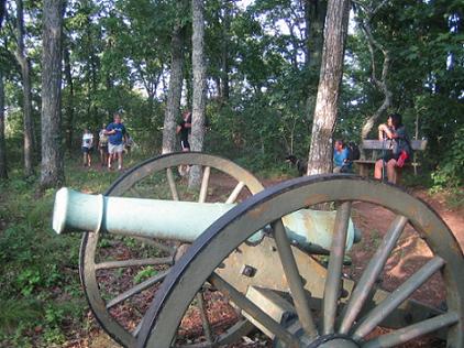
Kennesaw Mountain National Battlefield Park is a fantastic and very strenuous area for intown hiking and training. We will start at the visitors center and after introductions and a quick briefing hike the 1.2 miles to the 1808 foot top of Big Kennesaw Mountain which is a climb of about 800 feet. From there we will drop down about 500 feet to the gap between Big Kennesaw and Little Kennesaw Mountain, up and over the hump in the middle which is about a 20 foot climb heading towards Little Kennesaw and about a 50 foot climb heading back, then down to the base of Little Kennesaw. From there it's about a 300 foot climb to the top of Little Kennesaw at 1601 feet where we will take a very short break at Fort McBride at the cannons. After that we'll do the small loop on top of Little Kennesaw going by the historic "General French's Rock" and head back the same way we came which will mean a 50 foot climb up the hump, and a 500 foot climb up Big Kennesaw Mountain. So total ascent will be around 1670 feet and total descent will be around 1670 feet not counting the small ups and downs in doing the small loop. | |||||||
| |||||||
| How to Get There: | |||||||
| Event Directions: | 1) I-75 North to exit 267B Hwy 5 Canton Road Connector 2) If you are not heading west after getting off of the Interstate you are going the wrong way. You should be heading towards US 41 and downtown Marietta after getting off of I-75 onto the Canton Road Connector. 3) You will be tempted to take the first exit off of the Canton Road Connector which is US 41, but do not take it. Proceed over US 41 on a bridge staying on the Canton Road Connector. 4) After crossing US 41 take the next right at a redlight onto Church Street Extenson. 5) You should cross railroad tracks soon. 6) Take a left onto Old US 41 at a redlight. If you get to US 41 again, you have missed the turn onto Old US 41 so turn around. 7) Stay on Old US 41 until you pass in front of the mountain and park on the left or right-hand side of the road after passing the redlight for Stilesboro Road. Old US 41 is closed in order to replace the CSX railroad bridge. The signs will guide you take a left onto Stilesboro road. Don't turn left, but rather head straight through the barricades. There is room to drive your car through them. There is a small sign indicating overflow parking beyond the signs so it's okay. Park beyond the redlight and barricade on either side of the road. Meet prior to 6:10 PM at the cannon outside the main entrance of the visitor's center so we can complete the sign-in process and get underway on time. Call the trip leader if you are running late. | ||||||
| Notes: | |||||||
|
* We encourage all members to follow our Etiquette Guidelines while participating in AOC events. | |||||||
| Cost Includes: | No cost. | ||||||
Cancellation/Partial Attendance: Please review the AOC cancellation policy. *Note: This is a rain or shine hike - we will hike regardless of the weather - except for thunder, tornadoes or earthquakes... | |||||||
 Calendar of Events
 Event Places