Shining Rock, NC High Country Fall Color Weekend
|
|
The Basics: |
| Event Type: |  | Backpacking | |
|
Event Location: | |
Shining Rock Wilderness by Blue Ridge Pkwy, NC
| |
| Date(s) & Time: | | Fri, Oct 2 2009, Sat, Oct 3 2009, Sun, Oct 4 2009
7:45 am >> N/A (Carpool Departure: 8:00 am *log in for location*)
| |
| Registration Opens:
| |
Thu, Sep 24 2009 9:30 pm
| |
| Registration Cut Off:
| |
Thu, Oct 1 2009 8:00 pm
| |
| Event Duration: | | 3 Days & 2 Nights | |
| Difficulty Rating: | | D4: Moderate to Difficult | |
Trip Leader(s):
| | Charlie Cottingham
Brian Clements
 Email Trip Leader(s) Email Trip Leader(s)
You must be logged in to get the Trip Leader contact information.
| |
| Member Cost: | | None |
|
| Participant Info: |
| Who's Invited: | |
Members Only, 21 And Older Only
| |
| Maximum Group Size: | | 10 |
| Minimum Group Size: | | 5 |
| Number Registered So Far: | |
5 / 0 (To see who's signed up, log in to the Member Area)
|
| Are Dogs Permitted: | |
No
|
|
| Itinerary: |
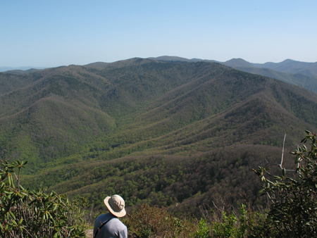
OVERVIEW: Join us for this exciting AOC backpacking adventure in the Shining Rock Wilderness and its lovely surrounding high country adjoining NC's Blue Ridge Parkway. The trees should already be showing off their fall colors in this gorgeous region of the Pisgah National Forest about 20 miles SW of Asheville that boasts several peaks over 6000 feet and incredible panoramic views from their summits.
Despite being consistently at some of the highest elevations east of the Rockies throughout our 3-day/2-night trek, it won't be overly strenuous. We begin at 5900' at our trailhead just off the Parkway and ascend to as high as 6214 feet, but never dip below 5000 feet (see trail profiles below). We'll plan to stop often to regroup, enjoy the scenery, and shoot photos.
We want to thank our friend Tony Ciccarello for his excellent work planning and writing up this trip and advising us about numerous sightseeing options. We know you love this place, Tony! Sorry you can't join us this time around.
Weather Note (10/1/09): We're in luck that the weather is shaping up nicely! The Nat'l Weather Svc forecasts no more than a 10% probability of precip for most of the weekend. A weak front is expected to pass through between Fri afternoon and early Sat bringing an increased prob. of precip, but no more than about 0.2 inch is expected and it should clear again by early Sat AM. Temps should be ideal for backpacking/camping and we expect only light winds less than 15 mph. (These 6000' peaks sometimes get very fogged in, and if that had been the forecast we might have considered rescheduling the trip.)
Day 1, Friday Oct 2: We'll depart at about 8:15 AM from our NE Metro Atlanta carpooling point (see below). This is a really pretty drive up through Clayton and into NC...very scenic through HIghlands and exciting as we climb higher and higher until we reach the Blue Ridge Parkway...then just another few miles to the trailhead. So the drive up is part of this event to to enjoy!...not just a way to get to the start. We will try to stop at a couple of nice overlooks to stretch our legs and take some pics.
Once we get to the main trailhead, we will either start out with a 2.9 mi roundtrip dayhike to the top of nearby Sam Knob (can be done with light daypacks) or just set out backpacking about 5 miles to Shining Rock Gap. This is over Black Balsam Knob (6214'), Tennent Mountain, Grassy Cove Top, and Flower Knob....these first two are mountain balds with panoramic views.
We will try to set up camp at Shining Rock Gap. This is a popular area... but if it is full, there are other campsites nearby we can use instead.
Day 2, Saturday Oct 3: Optional out and back dayhike to the summit of Cold Mountain (6030'). This is a "D4" fairly strenuous dayhike of about 8.5 miles. Those who don't want to do the hike can hang out around camp and relax. We will be doing the dayhike at a moderate but steady pace.
There is a full moon this night so maybe we'll do some sort of short night hike to make the most of it. Tony Ciccarello tells us he has been up there before on the mountain balds and didn't even need a headlamp with the moon so bright.
Day4, Sunday Oct 4: Get up, eat breakfast, then break camp (about 10:00 AM) and head back to parking. We may take the easy Ivestor Gap trail 4 mi back (down a dirt/gravel road) or if we are feeling energetic we can go back over Tennent and Black Balsam Knob. If we didn't do the Sam Knob dayhike at the start of the trip, we can do it as an optional dayhike to finish things up. Then we will drive through Brevard to get something to eat (after a quick stop at Looking Glass Falls right beside the road) and then head back to Atlanta. We should arrive back in the early evening.
This is another drop dead gorgeous area of western NC. Here is more info if you aren't familiar with it:
http://en.wikipedia.org/wiki/Art_Loeb_Trail
http://en.wikipedia.org/wiki/Black_Balsam_Knob
http://en.wikipedia.org/wiki/Cold_Mountain_(North_Carolina)
Elevation Profiles - (DON'T LET THESE SCARE YOU! The trails aren't nearly as steep as the profile graphs might indicate!!) Click on profile for larger version:
Parking to Shining Rock Gap Campsite with Backpacks
Total uphill climbing: ~1400 ft elev. gain over ~5 mile distance.

Shining Rock Gap to Cold Mountain out and back (dayhike)

Sam Knob out and back (dayhike)


|
|
Required Items to Bring:
- Backpack
- Lightweight Tent
- Warm Lightweight Sleeping Bag & Insulating Pad
- Headlamp or small Flashlight
- About 2 Liters of Water + Filter or other water treatment system
- Meals—You'll need the following:
- 2 Dinners (Fri & Sat)
- 2 Breakfasts (Sat & Sun)
- 2 Lunches (Sat & Sun)
- Freeze-dried meals (using a light camp stove for boiling water) + trail mix, jerky, etc. work well on trips like this.
- Sturdy Hiking Boots (comfortable & well-broken-in)
- Layered Clothing, spare dry Socks, etc. approp. for weather (Avoid cotton!)
- Cap & Light Rain Suit or Poncho
- Light Daypack or Fannie Pack for dayhikes
- A few "Mini-Toiletries, etc. | | Recommended Items to Bring:
Use our Event Checklists to make sure you have everything you need.
Trekking Poles
Camera | |
|
| How to Get There: |
| Event Directions: | | Directions will be summarized in a pre-trip welcome e-letter to all who are confirmed and reviewed at the Marriott carpool meeting point (8AM Fri). We intend to drive up together "caravan style" (via Clayton, GA, Highlands, NC, Cashiers, NC, Blue Ridge Pkwy, etc.) with several planned stops at view points, etc. en route. Our scenic route back to Atlanta Sunday afternoon will be different, with short excursions planned (e.g. Looking Glass Falls, Whitewater Falls, etc.) | |
| Carpool to Event Distance (round trip): | | 333Mile(s) |
| Carpool Departure Time: | |
8:00 am
|
| Carpool Location: | |
Log in for location
|
| Carpool Directions: | |
Log in for directions
|
| Carpool Cost: | |
Estimated cost per vehicle for this event is $133.20 using a reimbursement rate guideline of $0.400 per mile. The total amount should be divided by the number of people in the vehicle, including the driver. This is a guideline, not a rule, for drivers but the cost should not be higher unless there are extenuating circumstances.
|
|
| Notes: |
|
|
|
| Cost Includes: | | Free Event! But don't forget to chip in your fair share for gas & other vehicle expenses. |
Cancellation/Partial Attendance: Please review the AOC cancellation policy. |
 Print-Friendly Version


 Calendar of Events
 Event Places