 Print-Friendly Version Print-Friendly Version
|
AT Section - (new date) 3700 footers: Cowrock, Wolf Laurel, Levelland | |||||||
| The Basics: | |||||||
| Event Type: | Hike | ||||||
| Event Location: | North GA- Tesnatee Gap - 15 miles northwest of Cleveland, GA | ||||||
| Date(s) & Time: | Thu, Nov 5 2020 8:00 am >> Thu, Nov 5 2020 2:30 pm | ||||||
| Registration Opens: | Fri, Oct 23 2020 5:25 pm | ||||||
| Registration Cut Off: | Wed, Nov 4 2020 5:25 pm | ||||||
| Event Duration: | 6 Hours 30 Minutes | ||||||
| Difficulty Rating: | D5: Difficult | ||||||
| Distance: | 12 Miles | ||||||
| Pace: | Moderate | ||||||
| Trip Leader(s): | Gary 'L' Leigh B  Email Trip Leader(s) Email Trip Leader(s)
You must be logged in to get the Trip Leader contact information. | ||||||
| Member Cost: | None | ||||||
| Participant Info: | |||||||
| Who's Invited: | Members Only, 21 And Older Only | ||||||
| Maximum Group Size: | 10 | ||||||
| Minimum Group Size: | 4 | ||||||
| Number Registered So Far: | 7 / 0 (To see who's signed up, log in to the Member Area) | ||||||
| Are Dogs Permitted: | Yes | ||||||
| Itinerary: | |||||||
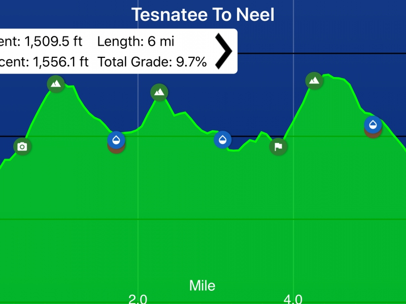
This section follows broad, rocky ridgetops offering excellent views. The longest climbs are on the north sides of Cowrock and Levelland Mountains. The section is within the Raven Cliffs Wilderness. There are no shelters. Itinerary: 0.0 mile Tesnatee Gap parking on GA 348 (elevation 3138 feet) no privy 1.0 mile Cowrock Mt. (elevation 3842) views of Yonah Mt., Brasstown Bald, and Town Creek gorge 1.8 mile Baggs Creek Gap (elevation 3591) 2.3 mile Wolf Laurel Top (elevation 3766) open rock face with excellent views 3.0 mile Rock Spring Top (elevation 3526) 3.8 mile Swaim Gap (elevation 3450) 4.3 mile Levelland Mt. (elevation 3942) open rocky area on crest 4.9 mile Bull Gap (elevation 3644) 6.0 mile Neel Gap (elevation 3125) Wasali-Yi Center is the only building the AT passes through Stats: Pace: 2.6-2.8 mph for the entire hike moving speed; up to 3.4 mph on flatter areas Moving time: 5 hours, 40 minutes (excluding 20 minutes for lunch/break) Mileage: 12 miles round trip Elevation gain: 3065 feet Total Grade: 9.7%
| |||||||
| |||||||
| How to Get There: | |||||||
| Event Directions: | Use google maps directions with the destination to enter being Tesnatee Gap: https://goo.gl/maps/AMizGZ9B8Q4DtDi1A
| ||||||
| Notes: | |||||||
|
* We encourage all members to follow our Etiquette Guidelines while participating in AOC events. | |||||||
| Cost Includes: | NA | ||||||
Cancellation/Partial Attendance: Please review the AOC cancellation policy. *Note: NA | |||||||
 Calendar of Events
 Event Places