 Print-Friendly Version Print-Friendly Version
|
AT Segment: 4400 foot Tray Mountain from Indian Grave Gap | |||||||
| The Basics: | |||||||
| Event Type: | Hike | ||||||
| Event Location: | Chattahoochee National Forest | ||||||
| Date(s) & Time: | Thu, Nov 12 2020 8:30 am >> Thu, Nov 12 2020 2:30 pm | ||||||
| Registration Opens: | Sun, Nov 8 2020 7:16 pm | ||||||
| Registration Cut Off: | Wed, Nov 11 2020 7:16 pm | ||||||
| Event Duration: | 6 Hours | ||||||
| Difficulty Rating: | D5: Difficult | ||||||
| Distance: | 13.2 Miles | ||||||
| Pace: | Moderate | ||||||
| Trip Leader(s): | Gary 'L' Leigh B  Email Trip Leader(s) Email Trip Leader(s)
You must be logged in to get the Trip Leader contact information. | ||||||
| Member Cost: | None | ||||||
| Participant Info: | |||||||
| Who's Invited: | Members Only, 21 And Older Only | ||||||
| Maximum Group Size: | 10 | ||||||
| Minimum Group Size: | 4 | ||||||
| Number Registered So Far: | 3 / 0 (To see who's signed up, log in to the Member Area) | ||||||
| Are Dogs Permitted: | Yes | ||||||
| Itinerary: | |||||||
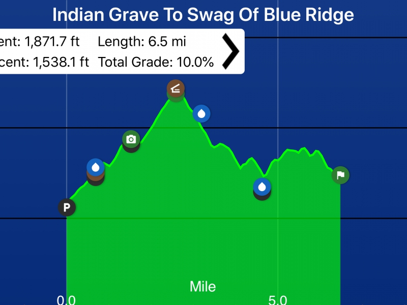
Weather: Mostly sunny, high near 68 degrees, 40% rain chance Elevation Gain: 3409.8 feet Total Grade: 10% Moving speed: up to 3.0mph; 2.5mph avg. This section contains some of the longest climbs and highest peaks on the AT in Georgia. It rarely descends below 3500 feet. This hike will cross the summit of Tray Mountain (4430 feet) and then follows the Swag of the Blue Ridge, a wide, low section. The climb to Tray starts at a low point for this section, Indian Grave Gap (3113 feet). The trail leads through the Tray Mountain Wilderness. Possible rest spots include Tray Mountain shelter, Steeltrap Gap campsite, and the Cheese Factory campsite. Highlights include Tray Mountain, with a splendid viewpoint, and the Swag of the Blue Ridge, a long ridgewalk. Tray Mountain is the 5th highest peak in GA. The last 3.7 mi of the drive is on a gravel road, so we need an SUV or high clearance vehicle. Hike mileposts: 0.0 Indian Grave Gap (3113) and 1317 foot ascent of Tray Mt. over 2.5 miles 1.0 Cheese Factory campsite 2.5 Tray Mt. (4430) with excellent views in all directions of the Georgia Mountains (Yonah, Currahee, Brasstown (highest peak in GA) , and Rabun Bald (2nd highest) 3.0 Tray Mt. Shelter with excellent views from the rocky ledges 3.5 unnamed gap (3760) 4.2 Wolfpen gap (3550) 4.8 Steeltrap gap (3500) after 930 foot descent from Tray 5.3 Young Lick Knob (3800) 6.6 Swag of the Blue Ridge (3400) one of the most remote areas of the AT in GA | |||||||
| |||||||
| How to Get There: | |||||||
| Event Directions: | Access is by a rough forest service road Google Maps for Indian Grave Gap:
https://goo.gl/maps/xnN5RwB6ey7jsB396 | ||||||
| Notes: | |||||||
|
* We encourage all members to follow our Etiquette Guidelines while participating in AOC events. | |||||||
| Cost Includes: | no parking fees | ||||||
Cancellation/Partial Attendance: Please review the AOC cancellation policy. | |||||||
 Calendar of Events
 Event Places