Panola Mountain Hidden Gems Hike, gathering at PATH Lyons Farm Trailhead north of Park
|
|
The Basics: |
| Event Type: |  | Hike | |
|
Event Location: | |
About 15 mi SE of downtown Atlanta, near I-20 Exit 68


| |
| Date(s) & Time: | | Thu, Jan 14 2021
11:00 am >> Thu, Jan 14 2021 3:00 pm
| |
| Registration Opens:
| |
Tue, Jan 12 2021 8:00 am
| |
| Registration Cut Off:
| |
Thu, Jan 14 2021 8:00 am
| |
| Event Duration: | | 4 Hours | |
| Difficulty Rating: | | D4: Moderate to Difficult | |
| Distance: | | 10 Miles | |
| Pace: | | Moderate | |
Trip Leader(s):
| | Charlie Cottingham
 Email Trip Leader(s) Email Trip Leader(s)
You must be logged in to get the Trip Leader contact information.
| |
| Member Cost: | | None |
|
| Participant Info: |
| Who's Invited: | |
Members Only, 21 And Older Only
| |
| Maximum Group Size: | | 10 |
| Minimum Group Size: | | 2 |
| Number Registered So Far: | |
9 / 0 (To see who's signed up, log in to the Member Area)
|
| Are Dogs Permitted: | |
No
|
|
| Itinerary: |
IN A NUTSHELL: Hope you can join us Thursday to explore the beautiful rugged terrain of Panola Mountain State Park - famous for its 300-million-year-old "better preserved little sister" of Stone Mountain. Our adventurous 4-hour trek will reveal lots of the "hidden gems" that make the Park such an ecological treasure. The weather forecast looks great! - Blue skies and warming quickly during the outing into the mid-50s.
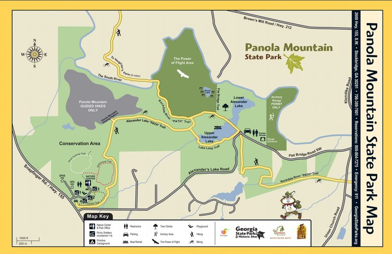
We'll park and gather a few minutes before 11:00 AM at the PATH Foundation's free roadside parking area & trailhead at the historic Lyons Farm - see my detailed Directions and GPS Info below. (On the above map our trailhead is about where the uppermost "hiker silhouette" is shown, near the South River.) After introductions we'll enter the Park southward on foot (at no charge) via a ~1-mile section of the paved Arabia Mtn PATH Trail and its wide footbridge over the South River.
This time we don't intend to include the mountain's protected summit, which is accessible only via a specially arranged prepaid & reserved hike guided by a Park ranger. But we will get to visit many of the Park's other massive granite outcrops & overlooks, + forests, meadows, lakes & streams, pausing occasionally to discuss the rare native flora & fauna, observe birds & wildlife and take photos. Let's each please bring a Picnic Lunch or midday snack which we can enjoy & share at one of our stops, as discussed in "Items to Bring" below.
After an almost complete loop of the Park via its amazing variety of trails and habitats we expect to be back at the cars by 3:00 PM.
MORE about the PARK'S TRAILS & FEATURES: Panola Mtn State Park offers a huge network of hiking & biking trails through its hundreds of acres of scenic terrain - plus camping, paddling, fishing, bouldering, tree-climbing, archery and a wonderful Nature Center for Park visitors. For more Panola Info click here: http://gastate parks.org/PanolaMountain ...and for an online Trail Map & Park brochure: http://explore.gastateparks.org/Files/GeorgiaParks/2020/panolamap2020-small.pdf
FASCINATING "MONADNOCK" GEOLOGY! Like its nearby "big sister," Stone Mountain, the exposed rocky outcrops at Panola Mountain are the remnants of a huge globule of molten rocky magma that bubbled up deep inside the earth's crust about 300 million years ago. Since then several miles of softer layers of earth and rock have eroded away above the hardening igneous globule, gradually revealing the massive granite "monadnock" and its surrounding outcrops and boulders - many of them appearing more than a mile from the main dome of the mountain. |
|
Required Items to Bring:
1. Wear comfortable weather- appropriate Clothing and Walking/ Athletic Shoes or Boots. If showers are forecast, carry a little lightweight Raingear or a compact Umbrella.
2. Hydrate in advance and carry a filled Water Bottle or two (or “Camelbak” hydration daypack etc).
3. Bring a lightweight Picnic Lunch or Snack + Beverage in your Daypack or Fanny Pack. We'll stop to enjoy & share these at a scenic spot along the way. | | Recommended Items to Bring:
Use our Event Checklists to make sure you have everything you need.
1. Camera and/or SmartPhone. There'll be lots of nice photo-ops.
2. Consider bringing Trekking Poles, esp. if you already have a pair and like to use them. They can be useful for balance and extra upper-body propulsion. A single Trekking Pole or a simple shoulder-high Hiking Stick can be almost as useful. | |
|
| How to Get There: |
| Event Directions: | | DIRECTIONS to the PATH Lyons Farm Trailhead (north of the Park) and its free Roadside Parking Area:
For a zoomable map or satellite view of this parking & gathering spot click the square blue & green "Event Location" icon near the top of this article.
GPS and MAPS.GOOGLE.com users: You can enter as your destination address either the following street address or its concise Lat/Lon coordinates:
- Street Address: 4431 Lyons Rd, Stonecrest, GA 30038
- Lat/ Lon: 33.6464, -84.1660 (being sure to include comma & minus sign.)
STEP-by-STEP DIRECTIONS from ATLANTA'S East Side:
1. From the I- 20/ I-285 Interchange on the east side of metro Atlanta proceed eastbound (toward Augusta) and immediately bear rightward onto Exit #68 ("Wesley Chapel Road").
2. Turn Right onto Wesley Chapel Rd (at the end of the long exit ramp), then continue eastward 0.3 mile, merging gradually leftward toward the 2nd traffic light at Snapfinger Rd.
3. Turn Left onto Snapfinger Rd and go 2.5 miles to the traffic light at GA-212 (Browns Mill Rd).
4. Turn Left onto GA-212 and go 2.5 miles to the traffic light at Evans Mill Rd/ Lyons Rd.
5. Turn Right onto Lyons Rd and go ~0.8 mile (bearing leftward around the first curve) to the PATH Arabia Trail junction on your left. There's a PATH sign and split-rail fence here where we'll gather. We'll parallel Park along the shaded shoulder of the main roadway just north of the PATH sign. The historic Lyons Farm's white home is at the end of Lyons Rd about 200 yards beyond this gathering spot, with a panoramic view of Panola Mountain above it. | |
|
| Notes: |
|
|
|
| Cost Includes: | | Free Event, with free Parking at the PATH Lyons Farm trailhead and free pedestrian entry into the Park. |
Cancellation/Partial Attendance: Please review the AOC cancellation policy. |
 Print-Friendly Version
 Calendar of Events
 Event Places