AtlantaOutdoorClub
sponsor
Print-Friendly Version
Add this event to your calendar (Outlook, iCalendar)
Add REGISTRATION REMINDER to your calendar


REGISTRATION REQUIRED: Once you've reviewed the event details, and decided you'd like to join us, you MUST sign up at the bottom of this page.


Summit GA's Highest Peaks: #10 - Eagle Mountain (4240')


The Basics:
Event Type:Hike
Event Location: Hiawassee, GA
Date(s) & Time:Sun, Oct 11 2009  8:15 am >> N/A  (Carpool Departure: 8:30 am   *log in for location*)
Registration Opens: Sun, Sep 20 2009 9:15 pm
Registration Cut Off: Fri, Oct 9 2009 8:00 pm
Event Duration:per itinerary
Difficulty Rating:D5: Difficult
Trip Leader(s):
Tony C
Scott Looper
Email Trip Leader(s)
You must be logged in to get the Trip Leader contact information.
Member Cost:None

Participant Info:
Who's Invited: Members Only, 21 And Older Only
Maximum Group Size:14
Minimum Group Size:4
Number Registered So Far: 9 / 0 (To see who's signed up, log in to the Member Area)
Are Dogs Permitted: No

Itinerary:

The North Georgia mountains may not be the Rockies (or the Himalayas), but they include many peaks that make for superb hiking and offer incredible views.   For this series, we are counting down the tallest mountains in GA.

For details on the other events in the series, visit the AOC forums...

Summit GA's Highest Peaks thread

#10 - Eagle Mountain

Join us as we kick off this series with a little known trail just outside of Hiawassee,  Eagle Mtn is 4240' above sea level with 600' of clean prominence.   It is on the western end of the sub chain that includes Hightower Bald near its eastern end.  

All of our hike will be along old logging roads...this means the trail is relatively wide but also not maintained.   The distance is about 8.5 miles round trip with 1900' of ascent on the way up but only 100' of descent...so as you can see from the elevation profile below, it is a fairly steady uphill climb.

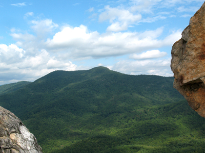
When we scouted out this hike, we did not expect any views from the top, but we were pleasantly surprised to find some rock outcroppings on the southwest side just below the summit.  This will be a great location for a long lunch break and provides sweet views of Brasstown Bald, Bell Knob, and parts of Lake Hiawassee far below.

Because the Eagle Mtn hike will not take more than about 4 hrs, we will also include Bell Knob in this event (trailhead is on the drive up).  This will both serve to give us a little warmup hike, but more importantly, we will get great views of Eagle...fun to see the sheer size of the mountain from that vantage point... and know we will be hiking all the way to the top of it very soon.

Unfortunately the top of Bell is not very naturalistic....the top is scarred from quartzite mining....and if that wasn't bad enough, there is graffiti littering most all of the exposed rockface.....however.....keep your gaze directed outwards and you will enjoy the views of Brasstown Bald to the NW, Eagle Mtn right next door to the E and Chatuge Lake/Hiawassee river to the W.   And it is still fun to climb on the rocks a bit.  We will also hike up a little side trail that offers views of Tray Mtn and Double Springs knob, another two of the top 10.

This should be a good fall foliage hike as well considering the leaves seem to be changing earlier this year so far. 

Summary:
- Trailhead to Eagle Mtn summit - 4.2 mi 1900' ascent, 100' descent
- Eagle Mtn summt to trailhead - 4.2 mi 100' ascent, 1900' descent
- Bell Knob hikes - ~2.0 mi, 900' ascent/descent

- Total distance: ~10.4 mi
- Total ascent/descent: ~2900 feet.
 
Eagle Mtn - Click on elevation profile for larger version:

PLEASE NOTE:
  • If rain is forecast, the hike will be rescheduled for a later date.
  • Because this a D5 event, if you have not very recently completed some tough AOC hikes, I will be contacting you to determine your level of fitness and experience. We are going to keep a moderate pace on the way up Eagle. 

  • Required Items to Bring:
  • emergency rain gear (even if chance of rain is minimal)
  • water
  • enough food to keep your energy level up
  • hiking boots or trail shoes
  • Recommended Items to Bring:
    Use our Event Checklists to make sure you have everything you need.
  • trekking poles
  • camera

  • How to Get There:
    Event Directions:

    Directions to trailhead will be given at carpool (or via email if "meeting at event").

    Carpool to Event Distance (round trip):190Mile(s)
    Carpool Departure Time: 8:30 am
    Carpool Location:   Log in for location
    Carpool Directions:   Log in for directions
    Carpool Cost: Estimated cost per vehicle for this event is $76.00 using a reimbursement rate guideline of $0.400 per mile. The total amount should be divided by the number of people in the vehicle, including the driver. This is a guideline, not a rule, for drivers but the cost should not be higher unless there are extenuating circumstances.

    Notes:
    * We encourage all members to follow our Etiquette Guidelines while participating in AOC events.

    Cost Includes:NA

    Cancellation/Partial Attendance:   Please review the AOC cancellation policy.
    *Note: NA