 Print-Friendly Version Print-Friendly Version
|
|
Advanced Backpacking from Tesnatee Gap to Unicoi Gap | |||||||
| The Basics: | |||||||
| Event Type: | Backpacking | ||||||
| Event Location: | Near Helen, GA | ||||||
| Date(s) & Time: | Sat, Feb 20 2010 12:00 pm >> N/A (Carpool Departure: 9:00 am *log in for location*) | ||||||
| Registration Opens: | Mon, Jan 25 2010 9:00 pm | ||||||
| Registration Cut Off: | Thu, Feb 18 2010 12:00 am | ||||||
| Event Duration: | 2 Days | ||||||
| Difficulty Rating: | D4: Moderate to Difficult | ||||||
| Trip Leader(s): | Jon Miner Email Trip Leader(s) Email Trip Leader(s)
You must be logged in to get the Trip Leader contact information. | ||||||
| Member Cost: | None | ||||||
| Participant Info: | |||||||
| Who's Invited: | Members Only, 21 And Older Only | ||||||
| Maximum Group Size: | 10 | ||||||
| Minimum Group Size: | 4 | ||||||
| Number Registered So Far: | 7 / 0 (To see who's signed up, log in to the Member Area) | ||||||
| Are Dogs Permitted: | No | ||||||
| Itinerary: | |||||||
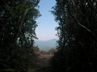
| *** This trip is intended for those in excellent shape. Be honest with yourself whether you have the physical ability and desire to do this event. Previous experience backpacking in mountain conditions is highly recommended and you should have been able to complete a less strenuous backpacking trip fairly comfortably. We will be keeping a good moderate pace as we hike thoughout the day and into camp. If you sign up and I do not know your hiking ability, I will contact you to find out if I believe you are a good candidate for this trip. I reserve the right to remove any member from this trip, who in my opinion, may not have the physical ability to keep up with the group. *** We'll be setting out on the AT heading north from Tesnatee Gap to Unicoi Gap staying the night at Low Gap Shelter. Overall mileage will be around 15 miles. We'll be getting an early start and drive up to Unicoi Gap where we will leave a car and then we'll shuttle the rest of the cars and people down to Tesnatee Gap. We'll start off at Tesnatee heading North, hiking 5.3 miles over rolling terrain to Low Gap Shelter where we will spend the night. The first day's mileage breaks down as follows: Tesnatee Gap to Wildcat Mountain: 0.7 miles, gaining ~400 ft Wildcat Mountain to Low Gap Shelter: 4.6 miles, descending ~600 ft and crossing over Poor Mountain Total mileage for the day: 5.3 miles Low Gap shelter only sleeps 7, so we will have to bring tents with us, especially since it may get very cold! Because the first day is only 5 miles, we'll can either take our time getting to the shelter or get there fast and relax until the sun goes down. The second day we'll pack up and make our way to Unicoi Gap slowly gaining elevation until we reach the top of Blue Mountain and then descending to Unicoi. We'll be covering 9.4 miles. Day two's mileage is as follows: Low Gap shelter to Blue Mountain: 8.0 miles ascending ~1000 ft Blue Mountain to Unicoi Gap: 1.4 miles descending ~1000 ft Total mileage for day 2: 9.4 miles | |||||||
| |||||||
| How to Get There: | |||||||
| Event Directions: | Head southeast on Indian Trail Rd/Indian Trail Lilburn Rd 0.1 mi 2. Turn left onto the ramp to Greenville 0.4 mi 3. Merge onto I-85 N 11.4 mi 4. Slight left at I-985 N (signs for Gainesville/I-985 N/Lanier Pkwy) 23.8 mi 5. Take exit 24 for US-129 N/State Hwy 369 W toward Gainesville/Cleveland 0.3 mi 6. Turn left at GA-11/GA-13/Jesse Jewell Pkwy NE/US-129 0.6 mi 7. Turn right at GA-11/Limestone Pkwy/US-129 Continue to follow GA-11 22.6 mi 8. Turn right at GA-75/Unicoi St 2.0 mi 9. Turn left to stay on GA-75/Unicoi St Continue to follow GA-75 We'll have GPS with us and we'll all travel together so we won't get lost. | ||||||
| Carpool to Event Distance (round trip): | 160Mile(s) | ||||||
| Carpool Departure Time: | 9:00 am | ||||||
| Carpool Location: | Log in for location | ||||||
| Carpool Directions: | Log in for directions | ||||||
| Carpool Cost: | Estimated cost per vehicle for this event is $64.00 using a reimbursement rate guideline of $0.400 per mile. The total amount should be divided by the number of people in the vehicle, including the driver. This is a guideline, not a rule, for drivers but the cost should not be higher unless there are extenuating circumstances. | ||||||
| Notes: | |||||||
|
- This trip is for advanced backpackers with recent experience of hiking 10 or more miles in the mountains. - We will be camping near the Low Gap Shelter, which has a spring and privy. * We encourage all members to follow our Etiquette Guidelines while participating in AOC events. | |||||||
Cancellation/Partial Attendance: Please review the AOC cancellation policy. | |||||||
 Calendar of Events
 Event Places