 Print-Friendly Version Print-Friendly Version
|
|
Joyce Kilmer/Citico Creek Wilderness | |||||||
| The Basics: | |||||||
| Event Type: | Backpacking | ||||||
| Event Location: |
Bob Stratton Bald/SlickRock Creek


| ||||||
| Date(s) & Time: | Thu, Jun 24 2021 6:45 am >> Sun, Jun 27 2021 6:00 pm (Carpool Departure: 6:45 am *log in for location*) | ||||||
| Registration Opens: | Tue, Jun 8 2021 8:00 pm | ||||||
| Registration Cut Off: | Mon, Jun 21 2021 8:00 pm | ||||||
| Event Duration: | 3 Days 11 Hours 15 Minutes | ||||||
| Difficulty Rating: | D6: Advanced | ||||||
| Distance: | 32 Miles | ||||||
| Pace: | Moderate | ||||||
| Trip Leader(s): | Michael J Email Trip Leader(s) Email Trip Leader(s)
You must be logged in to get the Trip Leader contact information. | ||||||
| Member Cost: | None | ||||||
| Participant Info: | |||||||
| Who's Invited: | Members Only, 21 And Older Only | ||||||
| Maximum Group Size: | 8 | ||||||
| Minimum Group Size: | 2 | ||||||
| Number Registered So Far: | 4 / 0 (To see who's signed up, log in to the Member Area) | ||||||
| Are Dogs Permitted: | No | ||||||
| Itinerary: | |||||||
We will start at the Beech Gap trailhead, spend the first night on top of Bob Stratton Bald. The 2nd and 3rd night we'll camp near Wildcat Falls along Slickrock Creek, saving the tough climb out on the 4th day. This hike is for very fit and experienced backpackers, because it's the wilderness, it's 3 nights, and it's rugged terrain in places. On day two we descend 3600'! And since this is a loop hike, we have the same elevation gain on the way back up! Wait, there's more! On the last day, we hike 12.4 miles, gaining 3600', but the first few miles is only a very gradual ascend. Think of it as a warm up. Then it gets very steep, especially in a few places, before popping out of the forest onto the bluffs approaching Naked Ground. If you're still interested at this point, here's the details... We'll hike 3.5 miles, and up almost 1k' elevation ascent to camp our first night on top of Bob Stratton Bald. This is a spectacular mountain vista high above the valleys with awesome views. The 2nd day we'll hike down into the Slickrock Valley, with a short detour to have lunch on top of Hangover. Total distance will be about 8 miles, but we'll descend about 3600'! Many yrs ago, I wrote the following description of this valley, for the Trail Critters backpacking group, long before joining the AOC. Thanks to Kristi for forwarding this to me. "Come join us in the valley of the giant toads and fat bats. We camp beside gentle rapids a short distance from Wildcat Falls. In a November trip I watched a small Black Bear walk across the top of the falls and disappear quietly into the forest. During the day, you can swim, hike, read, or do just about anything you want to do. Once we set up camp, we’ll stay there until it’s time to go back to the city. At night, for the more brave hearted, you can venture from the security of the campfire and look at the glowing worms or sit beside the giant croaking toads. Also, if you walk down to the top of the waterfalls and look up at the sky at twilight, you can watch the fat bats doing their best on bug control. Don’t worry, no vampire bats here!"
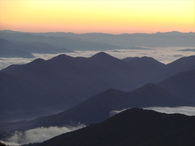
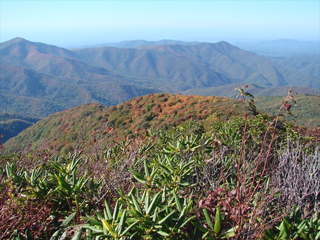
If the group decides to hike along Slickrock river on Saturday, water shoes will help the many river crossings. I plan on bringing a pair, because I love walking along Slickrock creek. There are typically two river crossings too deep to cross without getting your boots wet, before getting to camp on the 2nd day as well. The 4th day (Sunday) we'll hike up the Slickrock Creek trail gaining back all that elevation real quick on the north face of Naked Ground. The first 2.5 miles are relatively easy, but the next 3 miles go up almost 3k' and there were parts where it was so steep we dug in with our hands, feeling more like a climb than a hike. The views near the top and just north of Naked Ground are beautiful looking down over the valley below. Then a more gentle push to Stratton Bald, and then back down to the cars. The mileage on Sunday is only about 12.4 miles, but it's the elevation change that gets you. Since this will be a tough long hike, we plan on getting an early start Sunday morning. We can eat lunch at the top of Slickrock creek trail, near Naked Ground, or wait until Bob Stratton Bald if that works better based on our pace and energy level's. If you haven't done D6 backpacking trips with me, I will need a way to find out your fitness level and your experience. This will not be a race, from my point of view, but to avoid injury or lack of time spent near each of our base camps, it's mandatory, that you are experienced in mountain backpacking. Thanks for your cooperation in advance. Both of those pictures were taken from Hangover Knob on previous backpacking trips. If you would like to read an article I wrote several years ago, which is not exact, but it does describe the hike down Slickrock creek, and the hike up the face of Naked Ground, here you go: https://www.atlantaoutdoorclub.com/event/archivedetails.as p?eventid=3780 So, if you read that, you now know that there are yellow jackets. In June, they won't be as bad as they are in Sept. If you're allergic, bring an epi-pen, and let us know. There are ways to limit getting attacked, but none of them are guarantee's. It's an unfortunate side effect of being in that beautiful country... Michael Johnson
| |||||||
| |||||||
| How to Get There: | |||||||
| Event Directions: | Will be distributed at the Park and Ride | ||||||
| Carpool to Event Distance (round trip): | 282Mile(s) | ||||||
| Carpool Departure Time: | 6:45 am | ||||||
| Carpool Location: | Log in for location | ||||||
| Carpool Directions: | Log in for directions | ||||||
| Carpool Cost: | Estimated cost per vehicle for this event is $112.80 using a reimbursement rate guideline of $0.400 per mile. The total amount should be divided by the number of people in the vehicle, including the driver. This is a guideline, not a rule, for drivers but the cost should not be higher unless there are extenuating circumstances. | ||||||
| Notes: | |||||||
|
* We encourage all members to follow our Etiquette Guidelines while participating in AOC events. | |||||||
Cancellation/Partial Attendance: Please review the AOC cancellation policy. | |||||||
 Calendar of Events
 Event Places