 Print-Friendly Version Print-Friendly Version
|
|
Bikepacking :: Gravel Reaper v68 | |||||||
| The Basics: | |||||||
| STATUS: | Cancelled - Hide from Calendar | ||||||
| Event Type: | Mountain Biking | ||||||
| Event Location: |
Jake Mtn Lot


| ||||||
| Date(s) & Time: | Sat, Oct 4 2025 8:00 am >> Sun, Oct 5 2025 2:00 pm (Carpool Departure: 6:30 am *log in for location*) | ||||||
| Registration Opens: | Fri, Sep 26 2025 11:11 am | ||||||
| Registration Cut Off: | Thu, Oct 2 2025 11:11 am | ||||||
| Event Duration: | 1 Days 6 Hours | ||||||
| Difficulty Rating: | D6: Advanced | ||||||
| Distance: | 68 Miles | ||||||
| Pace: | Moderate | ||||||
| Trip Leader(s): | Horhay Email Trip Leader(s) Email Trip Leader(s)
You must be logged in to get the Trip Leader contact information. | ||||||
| Member Cost: | None | ||||||
| Participant Info: | |||||||
| Who's Invited: | Members Only, 21 And Older Only | ||||||
| Maximum Group Size: | 4 | ||||||
| Minimum Group Size: | 2 | ||||||
| Number Registered So Far: | 1 / 0 (To see who's signed up, log in to the Member Area) | ||||||
| Are Dogs Permitted: | No | ||||||
| Itinerary: | |||||||
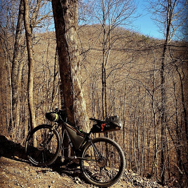
Almost FULL MOON Bikepacking in N. Ga!! - This is as real as it comes - this route combines the best of mountain biking, gravel riding & the best of UL backpacking all in one weekend! Itinerary: Day 1: The longest day in the saddle and we'll make stops as needed, we'll start off in a counter clockwise direction & call it a day at the campsites along the Toccoa River Swinging Bridge (as we jump off trail for a mile or so), but I definately want to stop at the Coopers Creek Store for a coke and some goodies b4 calling it a day! It's gonna be a solid 55 mile day tho! Monday is technically the FULL MOON, but we'll have lotsa night illumination, so there's that! Day 2: Starts with a 10 mile long climb! and ends with a blistering downhill almost all the way back to the parking lot! My RWGPS map is downloaded and ready for an all out assault of your skills, stamina, fitness and mental fortitude! Gravel Reaper - A bike ride in Lumpkin County, GA (ridewithgps.com) Saturday is "game day" for those that accept this bikepacking challenge. I'll probably be running my proper bikepacking rig that was set up for the TNGA so I'll have everything except the kitchen sink out there, but feel free to run whatever set up you think will help you be successful in completing the 68 mile loop. It's a hard, brutal loop and I plan on taking as many breaks as my legs, heart and mind require, so this is NO FKT effort. Planned stops are at Lake Winfield Scott (28 miles in), and at the Cooper's Creek Store (46.5 miles in). As I mentioned earlier, I will be stopping for a quick break wherever my legs tell me they need a rest! This is going to be a hard ride, there's lots of brutal climbing (the event headline photo at the top was from a trip I did out there last winter, you can see how steep some of the climbs are), and there's just as many bombing downhills. From redline heart rate climbs to white knuckle descents this event will test you, your gear and your will.
cut off the Friday start - so it's just an overnighter. Yeah C'mon! | |||||||
| |||||||
| How to Get There: | |||||||
| Event Directions: | GPS link above is right to the Jake Mountain parking lot of Nimblewell Rd. We roll from there at 8am SHARP | ||||||
| Carpool to Event Distance (round trip): | 111Mile(s) | ||||||
| Carpool Departure Time: | 6:30 am | ||||||
| Carpool Location: | Log in for location | ||||||
| Carpool Directions: | Log in for directions | ||||||
| Carpool Cost: | Estimated cost per vehicle for this event is $44.40 using a reimbursement rate guideline of $0.400 per mile. The total amount should be divided by the number of people in the vehicle, including the driver. This is a guideline, not a rule, for drivers but the cost should not be higher unless there are extenuating circumstances. | ||||||
| Notes: | |||||||
|
#ABFE * We encourage all members to follow our Etiquette Guidelines while participating in AOC events. | |||||||
Cancellation/Partial Attendance: Please review the AOC cancellation policy. | |||||||
 Calendar of Events
 Event Places

