 Print-Friendly Version Print-Friendly Version
|
|
Big Scaly Mountain Loop | |||||||
| The Basics: | |||||||
| Event Type: | Backpacking | ||||||
| Event Location: |
Big Scaly Mountain, NC


| ||||||
| Date(s) & Time: | Sat, Sep 25 2021 8:00 am >> Sun, Sep 26 2021 4:00 pm (Carpool Departure: 8:00 am *log in for location*) | ||||||
| Registration Opens: | Tue, Sep 21 2021 8:00 pm | ||||||
| Registration Cut Off: | Fri, Sep 24 2021 7:00 pm | ||||||
| Event Duration: | 1 Days 8 Hours | ||||||
| Difficulty Rating: | D5: Difficult | ||||||
| Distance: | 11 Miles | ||||||
| Pace: | Moderate | ||||||
| Trip Leader(s): | Todd M Kristi  Email Trip Leader(s) Email Trip Leader(s)
You must be logged in to get the Trip Leader contact information. | ||||||
| Member Cost: | None | ||||||
| Participant Info: | |||||||
| Who's Invited: | Members Only, 21 And Older Only | ||||||
| Maximum Group Size: | 8 | ||||||
| Minimum Group Size: | 2 | ||||||
| Number Registered So Far: | 8 / 0 (To see who's signed up, log in to the Member Area) | ||||||
| Are Dogs Permitted: | No | ||||||
| Itinerary: | |||||||
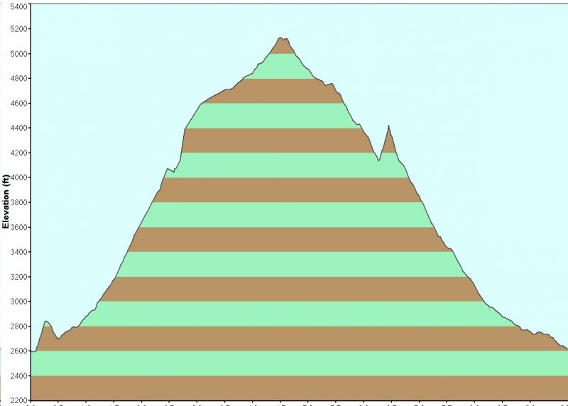
The weather should be ideal, so.. Let's Go Backpacking! Big Scaly is the mountain just below Standing Indian. This backpack is a loop of about 11 miles and has roughly 2,500 feet of elevation gain (and loss...see trail profile below). If you have not completed a D5 hike or backpack recently, expect to have some conversation with the trip leaders prior to the event.
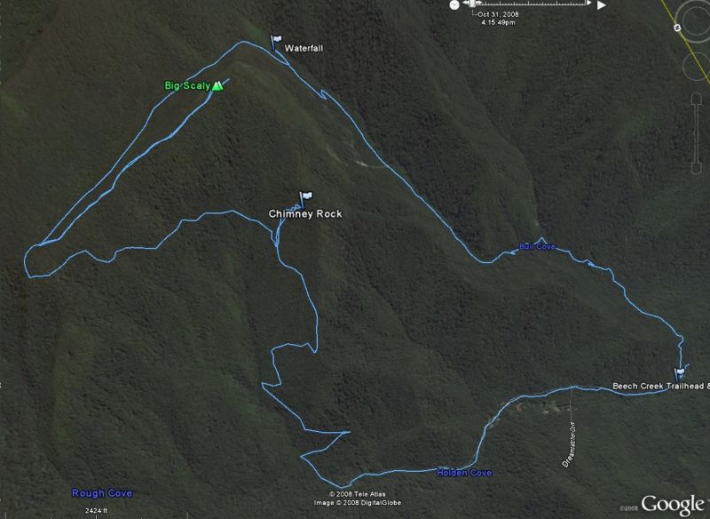
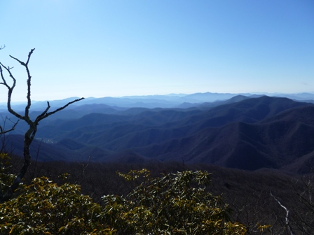
We will start by hiking up Chimney Rock trail. There is an optional quarter mile side trail to the right to view Chimney Rock if we have time. You can climb Chimney Rock and enjoy the unusual view and a bit of rock climbing exhilaration. There may be some overgrowth along part of the trail near the top. Once we reach the top past Case Knife Gap (5-6 miles in and 2000 ft in elevation gain), we will select a campsite along the high flat valley below Big Scaly Mountain. There is a nice small creek running through the area for a water source. After setting up camp we can take the +/-1 mile (round trip) trail to the summit of Big Scaly Mountain at 5,060 feet and enjoy fine long range views (see pic above). This is a western facing overlook so as an option we could gather wood for a fire, have an early dinner, and then hike to the summit for the sunset. Then we go down to Beech Creek trail head. We will walk about a mile down this road to get back to the cars (or we can shuttle a few cars up the road on Saturday). | |||||||
| |||||||
| How to Get There: | |||||||
| Event Directions: | Take I-85 N to I-985 N which turns into US 23/441 to Clayton GA. Pit stop at Ingles! (For bathrooms and "to go" only - we do not plan to sit down and eat.) Then go West on US 76 about eight miles. Turn right on Persimmon Rd, near the volunteer fire department and sign for Tallulah River Campgrounds. Continue about 4.2 miles to left at Tallulah River Rd. This road will turn to gravel after a mile or so and leads thru gorge to Tate City. Follow to NC state line. Parking will come up when it dead ends. | ||||||
| Carpool to Event Distance (round trip): | 220Mile(s) | ||||||
| Carpool Departure Time: | 8:00 am | ||||||
| Carpool Location: | Log in for location | ||||||
| Carpool Directions: | Log in for directions | ||||||
| Carpool Cost: | Estimated cost per vehicle for this event is $88.00 using a reimbursement rate guideline of $0.400 per mile. The total amount should be divided by the number of people in the vehicle, including the driver. This is a guideline, not a rule, for drivers but the cost should not be higher unless there are extenuating circumstances. | ||||||
| Notes: | |||||||
|
* We encourage all members to follow our Etiquette Guidelines while participating in AOC events. | |||||||
Cancellation/Partial Attendance: Please review the AOC cancellation policy. | |||||||
 Calendar of Events
 Event Places