 Print-Friendly Version Print-Friendly Version
|
Black, Ramrock, Gooch, and Justus Mountains: AT segment | |||||||
| The Basics: | |||||||
| Event Type: | Hike | ||||||
| Event Location: |
Suches, GA


| ||||||
| Date(s) & Time: | Tue, Feb 15 2022 9:00 am >> Tue, Feb 15 2022 3:00 pm (Carpool Departure: 7:45 am *log in for location*) | ||||||
| Registration Opens: | Thu, Feb 10 2022 1:43 pm | ||||||
| Registration Cut Off: | Sun, Feb 13 2022 1:00 pm | ||||||
| Event Duration: | 6 Hours | ||||||
| Difficulty Rating: | D5: Difficult | ||||||
| Distance: | 15 Miles | ||||||
| Pace: | Moderate | ||||||
| Trip Leader(s): | Gary 'L' Leigh B  Email Trip Leader(s) Email Trip Leader(s)
You must be logged in to get the Trip Leader contact information. | ||||||
| Member Cost: | None | ||||||
| Participant Info: | |||||||
| Who's Invited: | Members Only, 21 And Older Only | ||||||
| Maximum Group Size: | 12 | ||||||
| Minimum Group Size: | 4 | ||||||
| Number Registered So Far: | 11 / 0 (To see who's signed up, log in to the Member Area) | ||||||
| Are Dogs Permitted: | Yes | ||||||
| Itinerary: | |||||||
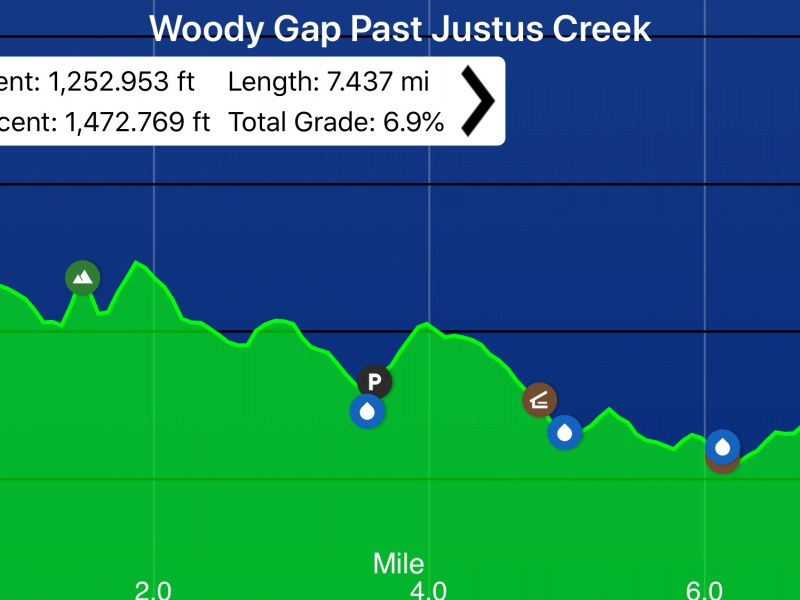
Let's do 4 easy (for Gary - not for most) mountains on the AT in one morning and also enjoy 3 streams including Blackwell and Justus creeks. Stopover if needed at the Gooch Mountain shelter at miles 5.3 and 9.7. This shelter has a picnic table. AT trail direction: south from Woody Gap trailhead parking (across the GA 60 road from the privy) Mileage: 15 Elevation Gain: 2700 feet Total Grade: 6.9% Moving speed: 2.8 mph Location: Chattahoochee National Forest; 15 miles west of Dahlonega D5 experience is required along with the ability to maintain a Pace in the Fast End of Moderate. If these qualifiations are not evident in your profile, we will contact you to request additional background on your qualification. We do this to be sure we have a group hike meeting the group's expectations. This section consists of long ridges that break gently to the north or west and more steeply to the south or east. The ridgetops offer fine views. Our elevations remain in a 600 foot range from Ramrock Mountain as the highest point to Justus Creek as the lowest point. Highlights include: mile 0 -1 - continues around the eastern slope of Black Mountain mile 1.5 - follow crest of Ramrock Mountain after 150 foot gain with views to the south mile 2.3 - large stand of poplar trees mile 5.6 - cross Blackwell Creek mile 6.2 - small stram crossing mile 6.8 - cross Justus Creek on rocks (lunch will probably be on the banks of the Creek on the return) mile 7.5 - turnaround point at old logging road | |||||||
| |||||||
| How to Get There: | |||||||
| Event Directions: | North on GA 400. Take a left onto SR 60/19 toward Dahlonega. At the fork of SR 60 and SR 19, go straight on SR 60. The trailhead is on the left at Woody Gap. All roads are paved. Click the link for Google Maps navigation to Woody Gap trailhead:
| ||||||
| Carpool to Event Distance (round trip): | 125Mile(s) | ||||||
| Carpool Departure Time: | 7:45 am | ||||||
| Carpool Location: | Log in for location | ||||||
| Carpool Directions: | Log in for directions | ||||||
| Carpool Cost: | Estimated cost per vehicle for this event is $50.00 using a reimbursement rate guideline of $0.400 per mile. The total amount should be divided by the number of people in the vehicle, including the driver. This is a guideline, not a rule, for drivers but the cost should not be higher unless there are extenuating circumstances. | ||||||
| Notes: | |||||||
|
* We encourage all members to follow our Etiquette Guidelines while participating in AOC events. | |||||||
Cancellation/Partial Attendance: Please review the AOC cancellation policy. | |||||||
 Calendar of Events
 Event Places