 Print-Friendly Version Print-Friendly Version
|
Duncan Ridge Trail: Toccoa River Swinging Bridge to Rhodes Mountain | |||||||
| The Basics: | |||||||
| Event Type: | Hike | ||||||
| Event Location: |
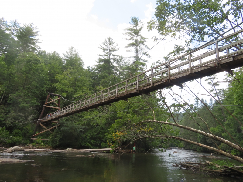
Toccoa River Bridge


| ||||||
| Date(s) & Time: | Tue, Mar 1 2022 8:30 am >> Tue, Mar 1 2022 4:30 pm (Carpool Departure: 6:30 am *log in for location*) | ||||||
| Registration Opens: | Wed, Feb 23 2022 1:02 pm | ||||||
| Registration Cut Off: | Mon, Feb 28 2022 5:02 pm | ||||||
| Event Duration: | 8 Hours | ||||||
| Difficulty Rating: | D6: Advanced | ||||||
| Distance: | 17 Miles | ||||||
| Pace: | Moderate | ||||||
| Trip Leader(s): | Gary 'L' Leigh B  Email Trip Leader(s) Email Trip Leader(s)
You must be logged in to get the Trip Leader contact information. | ||||||
| Member Cost: | None | ||||||
| Participant Info: | |||||||
| Who's Invited: | Members Only, 21 And Older Only | ||||||
| Maximum Group Size: | 10 | ||||||
| Minimum Group Size: | 3 | ||||||
| Number Registered So Far: | 9 / 0 (To see who's signed up, log in to the Member Area) | ||||||
| Are Dogs Permitted: | Yes | ||||||
| Itinerary: | |||||||
The Duncan Ridge Trail starts at Three Forks and winds its way to Blood Mt. It is a difficult, remote trail with outstanding payoffs and challenges. Join us in a series of hikes to explore the DRT from start to finish.
Part II - Toccoa River Swinging Bridge to Rhodes Mountain. This section of the Duncan Ridge Trail shares the trailbed with the Benton Mackaye Trail. We will head south towards the 270 foot swinging bridge that is high above the Toccoa River. After crossing the bridge, we will turn around, retrace our steps and begin the northern section of the trek. We will be climbing Wallalah Mountain, Licklog Mountain and finally, Rhodes Mountain. Somewhere along the way we will be stopping for lunch before retracing our steps back to the car. This section of trail is rugged and beautiful and is sure to make for an enjoyable day in the woods. This is a difficult hike with about 4500 feet of elevation gain. Recent D6/High D5 experience is required to join the fun. Your trip leaders reserve the right to move under qualified adventurers to the wait list. | |||||||
| |||||||
| How to Get There: | |||||||
| Event Directions: | We will be parking at the end of a 3 mile Forest Service Road off of Route 60, When you see the sign for 2 hikers it is time to turn at that sign onto the Forest Service Road which has a Toccoa Swinging Bridge sign. We meet at th dead end parking area to start the hike to the bridge. Here is the Google Maps link: https://goo.gl/maps/eDmCzQFg5vSPQSyX9
| ||||||
| Carpool to Event Distance (round trip): | 168Mile(s) | ||||||
| Carpool Departure Time: | 6:30 am | ||||||
| Carpool Location: | Log in for location | ||||||
| Carpool Directions: | Log in for directions | ||||||
| Carpool Cost: | Estimated cost per vehicle for this event is $67.20 using a reimbursement rate guideline of $0.400 per mile. The total amount should be divided by the number of people in the vehicle, including the driver. This is a guideline, not a rule, for drivers but the cost should not be higher unless there are extenuating circumstances. | ||||||
| Notes: | |||||||
|
* We encourage all members to follow our Etiquette Guidelines while participating in AOC events. | |||||||
Cancellation/Partial Attendance: Please review the AOC cancellation policy. | |||||||
 Calendar of Events
 Event Places