 Print-Friendly Version Print-Friendly Version
|
|
Woody Gap to Jarrard Gap and Back on the AT *Plan B, Still a D4 | |||||||
| The Basics: | |||||||
| Event Type: | Hike | ||||||
| Event Location: |
Near Suches, Georgia


| ||||||
| Date(s) & Time: | Sat, Mar 5 2022 10:30 am >> Sat, Mar 5 2022 4:30 pm | ||||||
| Registration Opens: | Tue, Mar 1 2022 8:03 pm | ||||||
| Registration Cut Off: | Fri, Mar 4 2022 6:00 pm | ||||||
| Event Duration: | 6 Hours | ||||||
| Difficulty Rating: | D4: Moderate to Difficult | ||||||
| Distance: | 11.6 Miles | ||||||
| Pace: | Moderate | ||||||
| Trip Leader(s): | Lisa Kristi  Email Trip Leader(s) Email Trip Leader(s)
You must be logged in to get the Trip Leader contact information. | ||||||
| Member Cost: | None | ||||||
| Participant Info: | |||||||
| Who's Invited: | Members Only, 21 And Older Only | ||||||
| Maximum Group Size: | 9 | ||||||
| Minimum Group Size: | 4 | ||||||
| Number Registered So Far: | 8 / 0 (To see who's signed up, log in to the Member Area) | ||||||
| Are Dogs Permitted: | No | ||||||
| Itinerary: | |||||||
*Edit: due to extenuating circumstances, we opted to start down at Lake Winfield Scott, hiked up along the Slaughter Creek Trail, on to the Appalachian Trail to the summit of Blood Mountain, back via the AT and then hopping onto the Jarrard Gap Trail at our would-be lunch spot, then back to the lake.
Let's enjoy this gorgeous spring weather on one of the most scenic sections of the Applalachian Trail, a moderately challenging 11.6 mile trek from Woody Gap to Jarrard Gap.
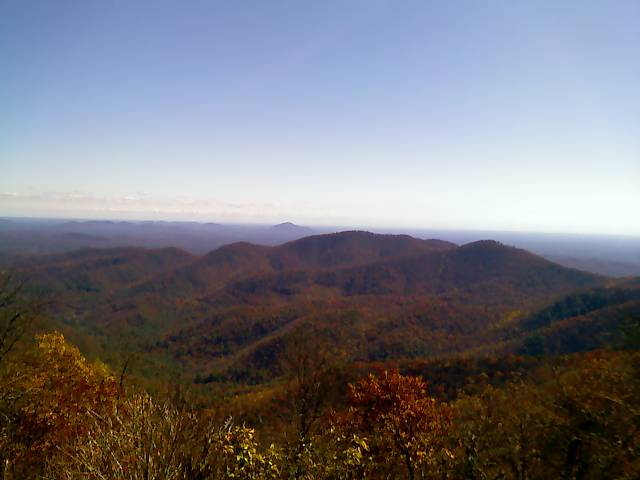
We will start at the easily accessible Woody Gap parking lot off GA 60 north of Dahlonega. We'll head north on the Appalachian Trail, beginning with some gentle climbs and descents through a hardwood forest. At a little over a mile, we'll climb a switchback to the top of Big Cedar Mountain, where we will enjoy sweeping vistas from an outcrop known as Preacher's Rock. From here, we'll pass multiple campsites and soon reach Miller Gap, where the Dockery Lake Trail joins the AT and where we should have an excellent view of the Blood Mountain Wilderness area. We will begin the hike no later than 10:30am. There are restrooms at the trailhead. This is not a beginner hike. It is a challenging D4 with plenty of ascents and descents. We will hike together as a group, so participants must be able to maintain the group pace. You may be contacted by the Trip Leader/removed from the event if you do not have sufficient recent D4-level experience.
| |||||||
| |||||||
| How to Get There: | |||||||
| Event Directions: | To Trailhead from Mansell Road & 400 North: > Take GA 400/US 19 north for approximately 53 miles to the intersection with GA 60. > Make a left on GA 60 (it's co-signed as US 19 for a while) and continue for a little over five miles to the trailhead. Watch the signage; GA 60 will make a right-hand turn at the bottom of the hill just before downtown Dahlonega. Also, when you get to the rock pile northwest of Dahlonega, continue straight on GA 60. The trailhead and a parking lot will be on the right; an additional parking lot is across the road. Parking is free. If you reach the town of Suches, you've gone too far. The published GPS coordinates for the trailhead are 34.677883, -83.999550.
| ||||||
| Notes: | |||||||
|
* We encourage all members to follow our Etiquette Guidelines while participating in AOC events. | |||||||
Cancellation/Partial Attendance: Please review the AOC cancellation policy. | |||||||
 Calendar of Events
 Event Places