 Print-Friendly Version Print-Friendly Version
|
|
Day Hike - Bald Mtn. in the Cohuttas | |||||||
| The Basics: | |||||||
| Event Type: | Hike | ||||||
| Event Location: | Cohuttas (Chestnut Lead Trail to Conasauga River and hike out on Tearbritches) | ||||||
| Date(s) & Time: | Sat, Mar 27 2010 7:30 am >> N/A (Carpool Departure: 7:45 am *log in for location*) | ||||||
| Registration Opens: | Tue, Feb 16 2010 9:00 pm | ||||||
| Registration Cut Off: | Fri, Mar 26 2010 5:00 pm | ||||||
| Event Duration: | 8.6 total hiking miles (includes 18 river crossings) | ||||||
| Difficulty Rating: | D5: Difficult | ||||||
| Trip Leader(s): | Paula Schubert Christopher Bolton  Email Trip Leader(s) Email Trip Leader(s)
You must be logged in to get the Trip Leader contact information. | ||||||
| Member Cost: | None | ||||||
| Participant Info: | |||||||
| Who's Invited: | Members Only, 21 And Older Only | ||||||
| Maximum Group Size: | 12 | ||||||
| Minimum Group Size: | 4 | ||||||
| Number Registered So Far: | 11 / 0 (To see who's signed up, log in to the Member Area) | ||||||
| Are Dogs Permitted: | No | ||||||
| Itinerary: | |||||||
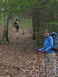
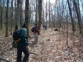
Join me for another adventure in the Cohutta Wilderness. This hike will require a car shuttle once we get to the trailhead, but it's a short 1 1/2 miles from each trailhead. First half of this hike is a moderate hike: We'll begin our day by hiking in on the Chestnut Lead Trail, which is an easy to moderate, 1.7 mile descent to the Conasauga River. We will cross the Conasauga River and continue hiking downstream (North) following the Conasauga River Trail. There will be 18 river crossings during this 3.5 mile stretch before we stop for a lunch break near Bray Field. The water will keep us cool and the crossings will be anywhere from mid-calf to knee deep depending on rainfall. Hiking poles or a hiking stick are required as it is for your own safety and enjoyment. After lunch and from Bray Field, we will pick up the Tearbritches trail. This trail is strenuous! It ascends very sharply in the first .2 of a mile and then gradually gains 2040 ft. in the next 2.7 miles before reaching the summit of Bald Mtn. at the 3 mile mark. It's a great workout because of the elevation gain, but I'm sorry to say there are no views from the top of the Bald. At the summit, we’ll be at approximately 4000 ft. in elevation before we will start our descent (.4 miles)to the Tearbritches Trail Head. We'll then shuttle a mile and a half back to the other cars. Staying hydrated is important. :) I'll be bringing my water filter with me, so if anyone needs to refill. Please Note:
| |||||||
| |||||||
| How to Get There: | |||||||
| Event Directions: | TO TRAILHEAD:
| ||||||
| Carpool to Event Distance (round trip): | 150Mile(s) | ||||||
| Carpool Departure Time: | 7:45 am | ||||||
| Carpool Location: | Log in for location | ||||||
| Carpool Directions: | Log in for directions | ||||||
| Carpool Cost: | Estimated cost per vehicle for this event is $60.00 using a reimbursement rate guideline of $0.400 per mile. The total amount should be divided by the number of people in the vehicle, including the driver. This is a guideline, not a rule, for drivers but the cost should not be higher unless there are extenuating circumstances. | ||||||
| Notes: | |||||||
|
Are Dogs Permitted? No, because of the numerous river crossings. (Email trip leaders for exceptions to the rule) Will this event occur rain or shine? No, not in severe weather. * We encourage all members to follow our Etiquette Guidelines while participating in AOC events. | |||||||
| Cost Includes: | Please bring cash for sharing gas expenses with carpool drivers. | ||||||
Cancellation/Partial Attendance: Please review the AOC cancellation policy. | |||||||
 Calendar of Events
 Event Places