 Print-Friendly Version Print-Friendly Version
|
|
Sweetwater Creek - Both Sides | ||||||||||||||
| The Basics: | ||||||||||||||
| Event Type: | Hike | |||||||||||||
| Event Location: |
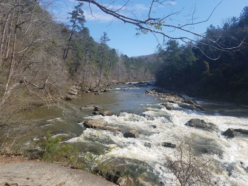
Sweetwater Creek State Park


| |||||||||||||
| Date(s) & Time: | Sun, Jan 29 2023 9:30 am >> Sun, Jan 29 2023 2:30 pm | |||||||||||||
| Registration Opens: | Tue, Jan 24 2023 7:01 pm | |||||||||||||
| Registration Cut Off: | Sun, Jan 29 2023 6:00 am | |||||||||||||
| Event Duration: | 5 Hours | |||||||||||||
| Difficulty Rating: | D4: Moderate to Difficult | |||||||||||||
| Distance: | 12 Miles | |||||||||||||
| Pace: | Moderate | |||||||||||||
| Trip Leader(s): | Joyce B. Email Trip Leader(s) Email Trip Leader(s)
You must be logged in to get the Trip Leader contact information. | |||||||||||||
| Member Cost: | None | |||||||||||||
| Participant Info: | ||||||||||||||
| Who's Invited: | Members Only, 21 And Older Only | |||||||||||||
| Maximum Group Size: | 12 | |||||||||||||
| Minimum Group Size: | 2 | |||||||||||||
| Number Registered So Far: | 9 / 0 (To see who's signed up, log in to the Member Area) | |||||||||||||
| Are Dogs Permitted: | No | |||||||||||||
| Itinerary: | ||||||||||||||
Join me for an intown D4 hiking 12 miles (about) of trails at Sweetwater Creek. We'll try to beat the crowds by hitting the Red trail first. We'll move on to the White trail with a detour on the Brown. After a break at the Visitor Center, we'll hike the Yellow and Orange trails. I'm skipping the Blue trail. Since they've started massive construction right at the edge of the park boundary, it's just too sad to witness. While this hike's pace is listed as "moderate", I keep a pace of 2.7-2.9 mph, so please be prepared to hike on the higher end of moderate. The Red and part of the White trails are rocky so some scrambling is involved. If you don't enjoy this type of hiking, you'll want to sit this out. Elevation gain will be around 1200-1400, so it's the miles that make this a D4. This is not a beginner hike. If I don't see D4s or some solid D3s in your history, I'll be contacting you. Sweetwater is a beautiful park with lots of history. If time allows after the hike, I encourage you to visit the excellent history and nature center.
| ||||||||||||||
| ||||||||||||||
| How to Get There: | ||||||||||||||
| Event Directions: |
| |||||||||||||
| Notes: | ||||||||||||||
|
$5 day pass or $50 annual pass. Both can be purchased on site or online. Day pass can be purchased at the kiosk in the parking area. You can also check out a Georgia State Parks pass at most public libraries. (But it's a good thing to support the parks and pay for a pass). * We encourage all members to follow our Etiquette Guidelines while participating in AOC events. | ||||||||||||||
Cancellation/Partial Attendance: Please review the AOC cancellation policy. | ||||||||||||||
 Calendar of Events
 Event Places