 Print-Friendly Version Print-Friendly Version
|
Duncan Ridge Trail - Toccoa River Swinging Bridge to Three Forks | |||||||
| The Basics: | |||||||
| Event Type: | Hike | ||||||
| Event Location: | Toccoa River Swinging Bridge | ||||||
| Date(s) & Time: | Fri, Apr 21 2023 8:30 am >> Fri, Apr 21 2023 3:30 pm (Carpool Departure: 6:30 am *log in for location*) | ||||||
| Registration Opens: | Thu, Apr 13 2023 7:00 pm | ||||||
| Registration Cut Off: | Thu, Apr 20 2023 5:00 pm | ||||||
| Event Duration: | 7 Hours | ||||||
| Difficulty Rating: | D6: Advanced | ||||||
| Distance: | 17 Miles | ||||||
| Pace: | Moderate | ||||||
| Trip Leader(s): | Leigh B Tim W  Email Trip Leader(s) Email Trip Leader(s)
You must be logged in to get the Trip Leader contact information. | ||||||
| Member Cost: | None | ||||||
| Participant Info: | |||||||
| Who's Invited: | Members Only, 21 And Older Only | ||||||
| Maximum Group Size: | 11 | ||||||
| Minimum Group Size: | 3 | ||||||
| Number Registered So Far: | 7 / 0 (To see who's signed up, log in to the Member Area) | ||||||
| Are Dogs Permitted: | Yes | ||||||
| Itinerary: | |||||||
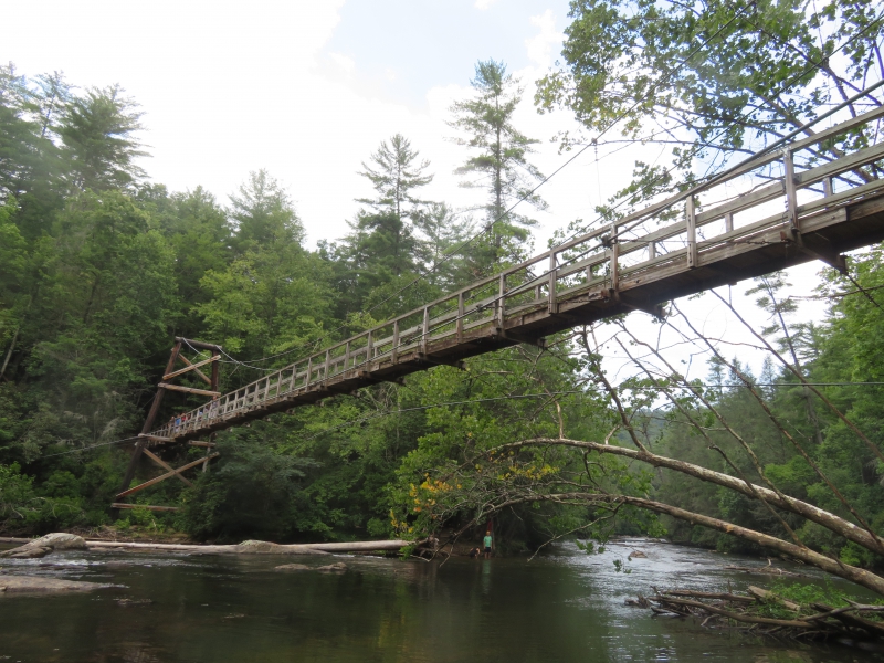
The Duncan Ridge Trail starts at Three Forks and winds its way to Blood Mt. It is a difficult trail and one which is awesome training for fitness or a challenging trip. This section is hard but always feels good upon completion. Toccoa River Swinging Bridge to Three Forks
At 270 feet, the Toccoa River Swinging Bridge is the longest swinging bridge east of the Mississippi. This strenuous hike will follow the DRT from the bridge all the way to the intersection of the AT. We will be climbing two mountains, Big John Dick and Little John Dick. A quick side trail will take us to Long Creek Falls and the opportunity for lunch. After a break, we will retrace our steps to complete our out and back adventure. We will be maintaining a pace on the
quick side of moderate, combined with over 17 miles and 4200 feet of ascent,
this hike is not for those without D6 experience. Please expect an e mail if your
profile does not reflect recent hard and consistent hiking with the club.
Thanks to Ron J for the original map. | |||||||
| |||||||
| How to Get There: | |||||||
| Event Directions: | We will be parking at the end of the service road heading to the swinging bridge. The service road is about 3 miles and it has been confirmed that it is clear of downed trees. | ||||||
| Carpool to Event Distance (round trip): | 0Mile(s) | ||||||
| Carpool Departure Time: | 6:30 am | ||||||
| Carpool Location: | Log in for location | ||||||
| Carpool Directions: | Log in for directions | ||||||
| Notes: | |||||||
|
* We encourage all members to follow our Etiquette Guidelines while participating in AOC events. | |||||||
Cancellation/Partial Attendance: Please review the AOC cancellation policy. | |||||||
 Calendar of Events
 Event Places