 Print-Friendly Version Print-Friendly Version
|
|
Cumberland Trail Laurel-Snow Segment | |||||||
| The Basics: | |||||||
| Event Type: | Hike | ||||||
| Event Location: |
Dayton, TN


| ||||||
| Date(s) & Time: | Wed, Apr 12 2023 9:30 am >> Wed, Apr 12 2023 3:30 pm (Carpool Departure: 7:30 am *log in for location*) | ||||||
| Registration Opens: | Thu, Mar 30 2023 7:00 pm | ||||||
| Registration Cut Off: | Wed, Apr 12 2023 6:29 am | ||||||
| Event Duration: | 6 Hours | ||||||
| Difficulty Rating: | D5: Difficult | ||||||
| Distance: | 13 Miles | ||||||
| Pace: | Moderate | ||||||
| Trip Leader(s): | RonnyJ (Call me Ron) Email Trip Leader(s) Email Trip Leader(s)
You must be logged in to get the Trip Leader contact information. | ||||||
| Member Cost: | None | ||||||
| Participant Info: | |||||||
| Who's Invited: | Members Only, 21 And Older Only | ||||||
| Maximum Group Size: | 10 | ||||||
| Minimum Group Size: | 3 | ||||||
| Number Registered So Far: | 9 / 0 (To see who's signed up, log in to the Member Area) | ||||||
| Are Dogs Permitted: | Yes | ||||||
| Itinerary: | |||||||
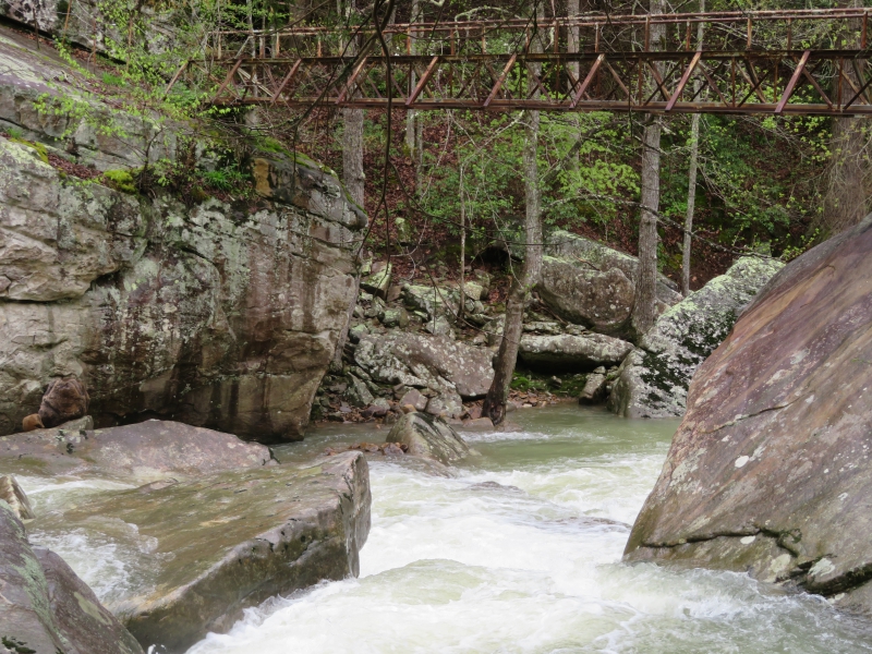
CT Laurel-Snow SegmentI had so much fun doing this trail I am going back for more! Join me as I continue to explore the southern portion of the Cumberland Trail. The Cumberland Trail is an ambitious hiking trail project currently under development. When completed, the CT will extend more than 300 miles from the Cumberland Gap in Kentucky to Signal Point, just outside of Chattanooga. Currently over 200 miles are open with the trail slated for completion in late 2019 (They didn't make it, the trail is still in work). Additionally, the CT is part of the Great Eastern Trail, which is under development and will extend from Alabama to New York when completed. Laurel- Snow This section is filled with difficult terrain, rock scrambles, waterfalls, gorges, awesome vistas and cool bridges. If you are looking for a hike on an iconic trail with tons of cool stuff to see, this is your hike! We will be stopping at all points of interest for picture taking and high hilarity. This is an out and back hike. If you have not been on the Cumberland Trail, you have been missing out! The trail is interesting, difficult and BEAUTIFUL! We will be starting at the trailhead just North of Dayton, Tn. Dayton is known for being the scene of the famous "Scopes Monkey Trial" in 1925. We will start the hike by going a short distance up Richland Creek until the intersection with Paine Creek. From here we will do a little off-trailing to head to Monkey Head Falls. After viewing the falls, we head back to the main trail. We will cross several bridges on our way to Snow Falls. There is a knee deep crossing (Morgan Creek) that we need to do on the way to this Fall. After Snow Falls we head towards Buzzard Point Overlook, the view there is breathtaking! After the overlook we will head to the base of Laurel Falls. Laurel Falls is a beautiful 80 footer! Now we head back to our cars to complete our T-shaped out and back adventure. This 13 mile hike features rugged terrain, rock scrambles and two creek crossings. You will need to bring water shoes. You must have recent D5 experience, be comfortable with a pace on the fast side of moderate and be prepared for difficult terrain to participate in this event. There will be plenty of opportunities to swim on this hike! | |||||||
| |||||||
| How to Get There: | |||||||
| Event Directions: | Click here for Trailhead Location Or enter "Laurel Snow State Natural Area" in your GPS app. | ||||||
| Carpool to Event Distance (round trip): | 250Mile(s) | ||||||
| Carpool Departure Time: | 7:30 am | ||||||
| Carpool Location: | Log in for location | ||||||
| Carpool Directions: | Log in for directions | ||||||
| Carpool Cost: | Estimated cost per vehicle for this event is $100.00 using a reimbursement rate guideline of $0.400 per mile. The total amount should be divided by the number of people in the vehicle, including the driver. This is a guideline, not a rule, for drivers but the cost should not be higher unless there are extenuating circumstances. | ||||||
| Notes: | |||||||
|
* We encourage all members to follow our Etiquette Guidelines while participating in AOC events. | |||||||
Cancellation/Partial Attendance: Please review the AOC cancellation policy. | |||||||
 Calendar of Events
 Event Places