 Print-Friendly Version Print-Friendly Version
|
|
Standing Indian, Mount Albert, Nantahala Basin Loop | |||||||
| The Basics: | |||||||
| Event Type: | Hike | ||||||
| Event Location: | Standing Indian Campground Backcountry Information Center. | ||||||
| Date(s) & Time: | Tue, Sep 12 2023 8:30 am >> Tue, Sep 12 2023 5:30 pm | ||||||
| Registration Opens: | Mon, Aug 21 2023 6:00 pm | ||||||
| Registration Cut Off: | Mon, Sep 4 2023 6:00 pm | ||||||
| Event Duration: | 9 Hours | ||||||
| Difficulty Rating: | D6: Advanced (Exploratory) | ||||||
| Distance: | 21.6 Miles | ||||||
| Pace: | Moderate | ||||||
| Trip Leader(s): | Leigh B Email Trip Leader(s) Email Trip Leader(s)
You must be logged in to get the Trip Leader contact information. | ||||||
| Member Cost: | None | ||||||
| Participant Info: | |||||||
| Who's Invited: | Members Only, 21 And Older Only | ||||||
| Maximum Group Size: | 12 | ||||||
| Minimum Group Size: | 3 | ||||||
| Number Registered So Far: | 5 / 0 (To see who's signed up, log in to the Member Area) | ||||||
| Are Dogs Permitted: | Yes | ||||||
|
Note: This is an "EXPLORATORY" trip. This means that there are parts of this trip, or perhaps the whole trip, that is new to your Trip Leader(s). However, they are confident that this will not be an issue. This note is here so that you can make an informed decision. When a Trip Leader isn't personally familiar with a trip, there is an increased chance of things not going as planned and you need to be prepared. The Trip Leader may have additional details in the itinerary. | |||||||
| Itinerary: | |||||||
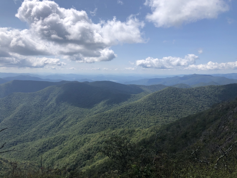
All trails described this hike very well so I will use the best parts of their description and modify a touch to detail the hike. This is a very popular loop trail that circles the headwaters of the Nantahala river. Standing Indian Basin is the horseshoe-shaped drainage formed by the Nantahala and Blue Ridge Mountains. This is the perfect loop trail: it includes 15 mi of the AT, has 2 summits with spectacular views and does not involve significantly difficult climbs. The walk involves a lot of ridgewalk and includes several prominent peaks over 5,000 feet in elevation—Albert Mountain, Big Butt, Little Bald, and Standing Indian Mountain which cap the rim of the drainage. What makes this area so attractive for hiking is the way the Appalachian Trail (AT) strangely forms about 270 degrees of a loop and easily connects with local trails. Parking is available at the Backcountry Information Center.(a few hundred yards past the camping turn offs. Look for a signboard and parking. We start this loop on the Long Branch Trail Start and proceed clockwise around the loop. I intend to drive up the afternoon before and stay in nearby Franklin at The Hampton Inn. I will have dinner in Franklin so if anyone wants to join me I can let you know the details. I am attaching the booking.com page. Feel free to find a buddy to share the price once the roster is up. This event has no carpool but once we get the roster signed up then one can be arranged.
| |||||||
| |||||||
| How to Get There: | |||||||
| Event Directions: | Link to trail head https://goo.gl/maps/AKoYQe4 bhcawLa1PA Standing Indian Campground physical address: 2037 Standing Indian Campground Rd Franklin, NC 28734 From Franklin, North Carolina, take U.S. Highway 64 west approximately 12 miles, passing through Winding Stair Gap. Near the bottom of the mountain from the gap, turn left on West Old Murphy Road (State Route 1448) and watch for a directional sign for the campground. Go 1.9 miles and turn right on Forest Road 67 at the Standing Indian Campground sign. This is a paved road. Go 1.7 miles and turn right into the campground. Keep straight on the road past the turns for camping and the Information Center isa large info board with some parking spots. Latitude 35° 4' 43.0000" N Longitude -83° 31' 54.9998" W | ||||||
| Notes: | |||||||
|
* We encourage all members to follow our Etiquette Guidelines while participating in AOC events. | |||||||
Cancellation/Partial Attendance: Please review the AOC cancellation policy. *Note: AOC Policy | |||||||
 Calendar of Events
 Event Places