 Print-Friendly Version Print-Friendly Version
|
|
Charlies Bunion Loop Backpacking | |||||||
| The Basics: | |||||||
| Event Type: | Backpacking | ||||||
| Event Location: | Smoky Mountains National Park near Cherokee, NC | ||||||
| Date(s) & Time: | Sat, May 1 2010 8:00 am >> N/A (Carpool Departure: 8:00 am *log in for location*) | ||||||
| Registration Opens: | Wed, Apr 14 2010 10:00 pm | ||||||
| Registration Cut Off: | Mon, Apr 26 2010 10:00 pm | ||||||
| Event Duration: | 2 days 1 night | ||||||
| Difficulty Rating: | D4: Moderate to Difficult | ||||||
| Trip Leader(s): | Geri Dominguez Denise Millon  Email Trip Leader(s) Email Trip Leader(s)
You must be logged in to get the Trip Leader contact information. | ||||||
| Member Cost: | None | ||||||
| Participant Info: | |||||||
| Who's Invited: | Members Only, 21 And Older Only | ||||||
| Maximum Group Size: | 8 | ||||||
| Minimum Group Size: | 0 | ||||||
| Number Registered So Far: | 7 / 0 (To see who's signed up, log in to the Member Area) | ||||||
| Are Dogs Permitted: | No | ||||||
| Itinerary: | |||||||
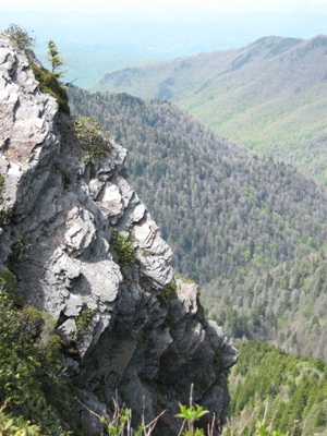
| Charlies Bunion Loop is composed of several trails (including the AT) in the Great Smoky Mountains National Park. This is a 13.6 mile lasso loop that delivers you to the high reaches of the Smoky Mountains, with the highest point being over 6000 feet. We will witness part of a jaw-dropping panorama that stretches from Mt. Leconte eastward to the jagged peaks of the Sawteeth Range. We will depart the carpool at 8:00AM and drive approx 3 1/2 hrs to the parking area at Newfound Gap. From there we traverse the AT, Sweat Heifer Trail, Grassy Branch Trail, Dry Sluice Gap Trail. We will stay the night in the Kephart Prong Shelter, a large stone hut tucked into a glade. There is a stream next to the shelter that will serve as our water source. The next morning, we will finish the loop and head back to the parking area. Day 1 mileage: 8.2 miles Day 2 mileage: 5.4 miles The drive back is about 3 hrs so we should get back late afternoon or early evening. If everyone wants we can stop on the way home for early lunch. This is a moderate to difficult trip, and you should be able to carry all your gear 13.6 miles over 2 days, with significant elevation gain. If you have not been on any prior AOC backpacking trips you will need to contact us and let us know your hiking experience to remain on the list for this trip. Note: there is an elevation gain of 3,000+ feet over the 13+ miles. Note: there is a food storage cable system at the shelter, so be sure to bring a plastic bag (or tent/sleeping bag sack) to store your food overnight. Another option is hanging your entire pack from the cables. In case you're curious about the name, I found this about its origin: Local outdoor writer Horace Kephart, hiking with his friend Charlie Conner, noticed, when Charlie complained of a bunion on his foot, took humorous advantage of the situation and equated Charlies bunion with the rock outcropping they had come accross to rest upon. | |||||||
| |||||||
| How to Get There: | |||||||
| Event Directions: | To Oconaluftee Visitor Center | ||||||
| Carpool to Event Distance (round trip): | 320Mile(s) | ||||||
| Carpool Departure Time: | 8:00 am | ||||||
| Carpool Location: | Log in for location | ||||||
| Carpool Directions: | Log in for directions | ||||||
| Carpool Cost: | Estimated cost per vehicle for this event is $128.00 using a reimbursement rate guideline of $0.400 per mile. The total amount should be divided by the number of people in the vehicle, including the driver. This is a guideline, not a rule, for drivers but the cost should not be higher unless there are extenuating circumstances. | ||||||
| Notes: | |||||||
|
* We encourage all members to follow our Etiquette Guidelines while participating in AOC events. | |||||||
Cancellation/Partial Attendance: Please review the AOC cancellation policy. | |||||||
 Calendar of Events
 Event Places