 Print-Friendly Version Print-Friendly Version
|
|
Finish the Pinhoti! (Rescheduled...Again!) | |||||||
| The Basics: | |||||||
| Event Type: | Hike | ||||||
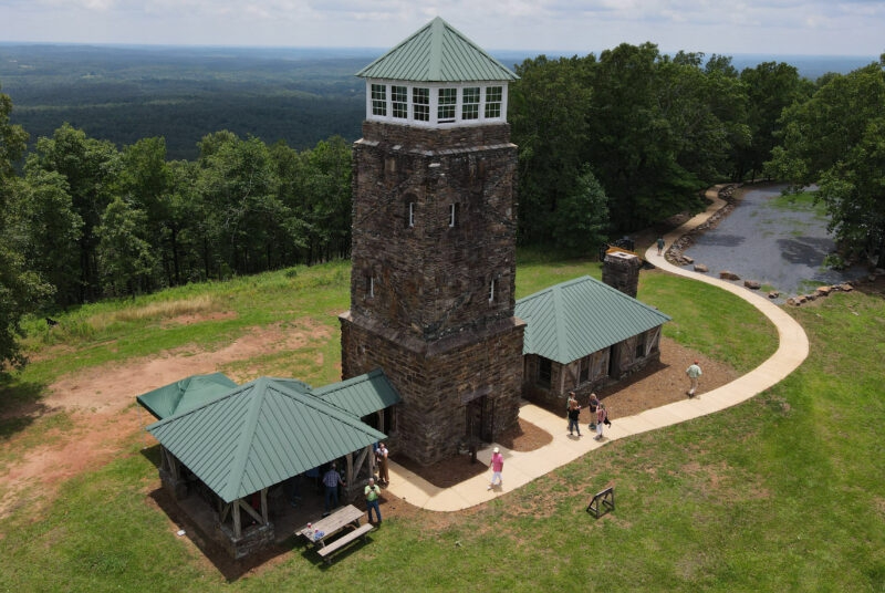
| Event Location: | Flagg Mountain, Alabama | ||||||
| Date(s) & Time: | Thu, Jan 18 2024 9:30 am >> Thu, Jan 18 2024 3:30 pm (Carpool Departure: 7:00 am *log in for location*) | ||||||
| Registration Opens: | Sat, Dec 16 2023 7:00 pm | ||||||
| Registration Cut Off: | Thu, Jan 18 2024 6:00 am | ||||||
| Event Duration: | 6 Hours | ||||||
| Difficulty Rating: | D5: Difficult (Exploratory) | ||||||
| Distance: | 13 Miles | ||||||
| Pace: | Moderate | ||||||
| Trip Leader(s): | RonnyJ (Call me Ron) Email Trip Leader(s) Email Trip Leader(s)
You must be logged in to get the Trip Leader contact information. | ||||||
| Member Cost: | None | ||||||
| Participant Info: | |||||||
| Who's Invited: | Members Only, 21 And Older Only | ||||||
| Maximum Group Size: | 10 | ||||||
| Minimum Group Size: | 3 | ||||||
| Number Registered So Far: | 6 / 0 (To see who's signed up, log in to the Member Area) | ||||||
| Are Dogs Permitted: | Yes | ||||||
|
Note: This is an "EXPLORATORY" trip. This means that there are parts of this trip, or perhaps the whole trip, that is new to your Trip Leader(s). However, they are confident that this will not be an issue. This note is here so that you can make an informed decision. When a Trip Leader isn't personally familiar with a trip, there is an increased chance of things not going as planned and you need to be prepared. The Trip Leader may have additional details in the itinerary. | |||||||
| Itinerary: | |||||||
Celebrate Good Times, Come ON! After 38 hikes and 532 miles, today brings us the last day of my quest to complete the Pinhoti Trail. We start today at the southern terminus of the trail, Flagg Mountain. Flagg Mountain is the southernmost mountain of the Appalachain chain, and some say, should be the start of the Appalachain Trail. The first 1.8 miles of this trek will take us to the top of Flagg with its stone fire tower. Topping out at over 1100 feet of elevation, Flagg is no Brasstown Bald, but a mountain it is so, hike it we must. After the summit we will hike past CCC built cabins and mostly rolling hills except one rather steep climb. Once we reach County Road 56, the trail and road merge, so we will turn around and retrace our steps. Once we resummit Flagg, we will take the shorter, paved, pedestrian trail down to our waiting cars. Somewhere along the way we will stop for lunch. We will be moving at a brisk pace, averaging about 2.9 mph with downhill and flat sections easily topping 3 mph. This is a long D5 event, recent D5 hiking is required to join the fun. | |||||||
| |||||||
| How to Get There: | |||||||
| Event Directions: | We will meet at the Pinhoti Trail Southern Terminus: | ||||||
| Carpool to Event Distance (round trip): | 300Mile(s) | ||||||
| Carpool Departure Time: | 7:00 am | ||||||
| Carpool Location: | Log in for location | ||||||
| Carpool Directions: | Log in for directions | ||||||
| Carpool Cost: | Estimated cost per vehicle for this event is $120.00 using a reimbursement rate guideline of $0.400 per mile. The total amount should be divided by the number of people in the vehicle, including the driver. This is a guideline, not a rule, for drivers but the cost should not be higher unless there are extenuating circumstances. | ||||||
| Notes: | |||||||
|
* We encourage all members to follow our Etiquette Guidelines while participating in AOC events. | |||||||
Cancellation/Partial Attendance: Please review the AOC cancellation policy. | |||||||
 Calendar of Events
 Event Places