|
This hike continues a series of D4 hikes through the fall and winter on the Georgia portion of the world famous Appalachian Trail, the world's longest continuously maintained footpath only trail. Every year, 5000 thru hikers embark on a journey to complete this 14-state trail within a 12 month period but only a fraction complete it. Others pursue the coveted 2000 miler designation by completing this 2198.4 mile trail over several years or decades. Here's a chance to dip your toes in that water. America's first National Scenic Trail, this trail receives over one million visitors annually.
Each of the hikes we do will be at least 8 miles long and gain at least 1500 feet of elevation. These are out and back hikes which means we will be doing 4 miles each way with most of the elevation gain on the front half of the hike. This hike plan is much more gentle than most of the club's AT hikes which are usually D5 or D6 and occasionally a D7. The southern AT has log bridges and/or stepping stones so no wet fords are expected. For a trail in national forests and wilderness management areas, the trail is considerably well-maintained.
We will start in the northermost high country of the state for an early start to leaf watching and head south in future weeks to follow the foliage and then move into winter further south for clear open ridgeline views when the leaves have gone.
Qualifications for these hikes include recent AOC experience hiking D3s or above. You will need to have had a few hikes at the D3 level with the AOC to be on this hike and have shown that you are able to keep pace with the group. These planned series of hikes assume a pace of 2.5mph and 30 minutes of break time including lunch. If you do not appear to meet the qualifcations, you will be moved from the Roster to the Wait List and have an opportunity to reach out to me to discuss.
Hike 1: "Blue Ridge Gap to the state border and beyond" to a view of Hiawassee and Standing Indian Mt. Elevation gain of 1800 feet out and 300 feet back. Summit elevation of 4500 feet. Completed October 6.
Hike 2: "Georgia Rollercoaster on the Appalachian Trail" section with short, steep, knob climbs. Elevation gain of 1800 feet out and 900 feet back. Summit elevation of 3500 feet. Completed October 10.
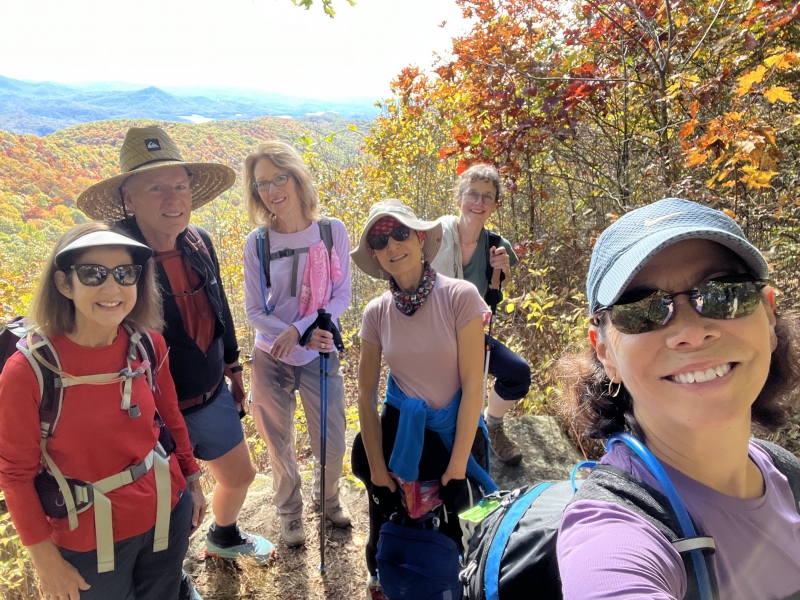
Hike 3: "Kelly Knob of Double Spring Mountain on the Appalachian Trail" which is one of the highest points on the Georgia AT. Elevation gain of 2000 feet out and 500 feet back. Summit elevation of 4100 feet. Completed October 17.
Hike 4: "Twin 4000 ft. summits of Tray Mt. and Rocky Mt. (north slope) on the Appalachian trail" with views from the rock outcroppings. Elevation gain of 2100 feet out and 100 feet back. Summit elevation of 4400 feet. Completed October 25.
Hike 5: "Twin 4000 ft. summits of Rocky Mt (south slope) and Blue Mt. on the Appalachian Trail" with an elevation gain over 1000 feet for the Rocky Mt. rock outcropping and over 1100 feet for the Blue Mt. shelter. Summit elevations 4000 feet. Completed Nov. 2.
Hike 6: "Wildcat Ridge, Cowrock, and Wolf Laurel Mtns. on the Appalachian Trail" with rock outcropping views from summits of 3800 feet. Elevation gain of 1200 northbound and 1000 southbound. Completed November 16.
Hike 7: "Sheep Top Rock on the Appalachian Trail" with a view from 3500 feet. Elevation gain of 800 feet northbound and 1200 feet southbound. Completed Nov. 30.
Hike 8: "Blood Mountain and Wasali-Yi on the Appalachian Trail" for the highest point at 4442 feet on the Georgia AT and the most visited vista of the first 199 miles of the AT. Elevation gain of 1400 feet southbound and 800 feet northbound. Completed Dec. 7.
Hike 9: "Preachers Rock and Ramrock Mtn. on the Appalachian Trail" with fine views to the southeast. Summit of 3500 feet. Elevation gain of 1200 northbound and 600 southbound. Completed Dec. 14.
Hike 10: "Devil's Kitchen and Some Creeks on the Appalachian Trail" and stepping stones. Elevation gain of 750 feet in both directions and elevations below 3000 feet as we head into winter. Completed Dec. 28.
Hike 11: "Sassaras Mt. and the 5 sister hills on the Appalachian Trail" for the last vista southbound before the Springer Mt.visita. Elevation gain of 800 feet southbound and 1000 feet norhtbound. Summit is over 3000 feet. Completed January 5.
Hike 12: "Three Forks, Long Creek Falls, and Hickory Flats on the Appalachian Trail". Elevation gain of 1000 feet northbound and 500 feet southbound. Scheduled for March 29.
|
 Print-Friendly Version


 Email Trip Leader(s)
 Calendar of Events
 Event Places