 Print-Friendly Version Print-Friendly Version
|
|
Chattooga Wild & Scenic River Section 3 or 3.5 | ||||||||||||||||||||||||||||||||||||||||||||||||||||||||||||||||||||||||||||||||||||||||||||||||||||||||||||||||||||||||||||||||
| The Basics: | ||||||||||||||||||||||||||||||||||||||||||||||||||||||||||||||||||||||||||||||||||||||||||||||||||||||||||||||||||||||||||||||||
| Event Type: | Whitewater | |||||||||||||||||||||||||||||||||||||||||||||||||||||||||||||||||||||||||||||||||||||||||||||||||||||||||||||||||||||||||||||||
| Event Location: | Chattooga River Hwy 76 Parking Area | |||||||||||||||||||||||||||||||||||||||||||||||||||||||||||||||||||||||||||||||||||||||||||||||||||||||||||||||||||||||||||||||
| Date(s) & Time: | Sun, May 23 2010 10:00 am >> N/A (Carpool Departure: 8:15 am *log in for location*) | |||||||||||||||||||||||||||||||||||||||||||||||||||||||||||||||||||||||||||||||||||||||||||||||||||||||||||||||||||||||||||||||
| Registration Opens: | Mon, May 17 2010 8:00 pm | |||||||||||||||||||||||||||||||||||||||||||||||||||||||||||||||||||||||||||||||||||||||||||||||||||||||||||||||||||||||||||||||
| Registration Cut Off: | Sat, May 22 2010 10:00 pm | |||||||||||||||||||||||||||||||||||||||||||||||||||||||||||||||||||||||||||||||||||||||||||||||||||||||||||||||||||||||||||||||
| Event Duration: | 9 hrs. | |||||||||||||||||||||||||||||||||||||||||||||||||||||||||||||||||||||||||||||||||||||||||||||||||||||||||||||||||||||||||||||||
| Difficulty Rating: | D4: Moderate to Difficult | |||||||||||||||||||||||||||||||||||||||||||||||||||||||||||||||||||||||||||||||||||||||||||||||||||||||||||||||||||||||||||||||
| Trip Leader(s): | Dirk Email Trip Leader(s) Email Trip Leader(s)
You must be logged in to get the Trip Leader contact information. | |||||||||||||||||||||||||||||||||||||||||||||||||||||||||||||||||||||||||||||||||||||||||||||||||||||||||||||||||||||||||||||||
| Member Cost: | None | |||||||||||||||||||||||||||||||||||||||||||||||||||||||||||||||||||||||||||||||||||||||||||||||||||||||||||||||||||||||||||||||
| Participant Info: | ||||||||||||||||||||||||||||||||||||||||||||||||||||||||||||||||||||||||||||||||||||||||||||||||||||||||||||||||||||||||||||||||
| Who's Invited: | Members Only, 21 And Older Only | |||||||||||||||||||||||||||||||||||||||||||||||||||||||||||||||||||||||||||||||||||||||||||||||||||||||||||||||||||||||||||||||
| Maximum Group Size: | 10 | |||||||||||||||||||||||||||||||||||||||||||||||||||||||||||||||||||||||||||||||||||||||||||||||||||||||||||||||||||||||||||||||
| Minimum Group Size: | 2 | |||||||||||||||||||||||||||||||||||||||||||||||||||||||||||||||||||||||||||||||||||||||||||||||||||||||||||||||||||||||||||||||
| Number Registered So Far: | 2 / 0 (To see who's signed up, log in to the Member Area) | |||||||||||||||||||||||||||||||||||||||||||||||||||||||||||||||||||||||||||||||||||||||||||||||||||||||||||||||||||||||||||||||
| Are Dogs Permitted: | No | |||||||||||||||||||||||||||||||||||||||||||||||||||||||||||||||||||||||||||||||||||||||||||||||||||||||||||||||||||||||||||||||
| Itinerary: | ||||||||||||||||||||||||||||||||||||||||||||||||||||||||||||||||||||||||||||||||||||||||||||||||||||||||||||||||||||||||||||||||
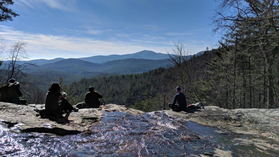
 Picture from upper Dick's creek overlooking the chattooga! Note! This is a hard boater trip, not a rafting one! Section III Section III runs from Earl's Ford to the Highway 76 Bridge, 14 miles. It has an excellent mix of rapids, mostly class II and class III, however many of them require scouting for the Chattooga novice. Some of those recommended for scouting include: Dick's Creek (aka First Ledge) the line is about 20' off shore, river right; Second Ledge, the line is about 10' off shore, river left; and Painted Rock, the move is river left to river right. The Narrows is also another foreboding space on the river. While it is difficult to scout (it is canyon-like with steep, rock walls where the river narrows) the general rule is to eddy hop and stay right at the bottom. While the left bottom drop does not look dangerous, it is. The largest rapid on Section III is also almost the last, Bull Sluice, a mandatory scout. This class IV-V rapid, dependent on water level, will be the greatest moment in a Section III trip, if run. However, for those who have not yet developed the whitewater skills to run it, it can easily be portaged on the right (west) side. For section 3.5 will put on at Thrift's Ferry about 3 miles from Hwy 76 & paddle down to Woodall Shoals about 3 miles past the bridge. Both the Bull & Woodall can be portaged with not to much trouble to make this a class 3 run. River level: Section 3 above 1.8 Section 3.5 below 1.8 as of this time it's running 2.15 Personal Preparedness and Responsibility: Be a competent swimmer Wear a life jacket. Wear a solid, correctly-fitted helmet Whitewater rivers contain many hazards which are not always easily recognized: High Water, Cold, Strainers, Dams, weirs, ledges, reversals, holes, and hydraulics are, but a few hazards that we come across. Be practiced in self rescue, individual paddlers are ultimately responsible for their own safety, and must assume sole responsibility for there decisions You should have good water reading skills from your boat, as we go through some of the longer rapids. | ||||||||||||||||||||||||||||||||||||||||||||||||||||||||||||||||||||||||||||||||||||||||||||||||||||||||||||||||||||||||||||||||
| ||||||||||||||||||||||||||||||||||||||||||||||||||||||||||||||||||||||||||||||||||||||||||||||||||||||||||||||||||||||||||||||||
| How to Get There: | ||||||||||||||||||||||||||||||||||||||||||||||||||||||||||||||||||||||||||||||||||||||||||||||||||||||||||||||||||||||||||||||||
| Event Directions: |
| |||||||||||||||||||||||||||||||||||||||||||||||||||||||||||||||||||||||||||||||||||||||||||||||||||||||||||||||||||||||||||||||
| Carpool to Event Distance (round trip): | 190Mile(s) | |||||||||||||||||||||||||||||||||||||||||||||||||||||||||||||||||||||||||||||||||||||||||||||||||||||||||||||||||||||||||||||||
| Carpool Departure Time: | 8:15 am | |||||||||||||||||||||||||||||||||||||||||||||||||||||||||||||||||||||||||||||||||||||||||||||||||||||||||||||||||||||||||||||||
| Carpool Location: | Log in for location | |||||||||||||||||||||||||||||||||||||||||||||||||||||||||||||||||||||||||||||||||||||||||||||||||||||||||||||||||||||||||||||||
| Carpool Directions: | Log in for directions | |||||||||||||||||||||||||||||||||||||||||||||||||||||||||||||||||||||||||||||||||||||||||||||||||||||||||||||||||||||||||||||||
| Carpool Cost: | Estimated cost per vehicle for this event is $76.00 using a reimbursement rate guideline of $0.400 per mile. The total amount should be divided by the number of people in the vehicle, including the driver. This is a guideline, not a rule, for drivers but the cost should not be higher unless there are extenuating circumstances. | |||||||||||||||||||||||||||||||||||||||||||||||||||||||||||||||||||||||||||||||||||||||||||||||||||||||||||||||||||||||||||||||
| Notes: | ||||||||||||||||||||||||||||||||||||||||||||||||||||||||||||||||||||||||||||||||||||||||||||||||||||||||||||||||||||||||||||||||
|
* We encourage all members to follow our Etiquette Guidelines while participating in AOC events. | ||||||||||||||||||||||||||||||||||||||||||||||||||||||||||||||||||||||||||||||||||||||||||||||||||||||||||||||||||||||||||||||||
Cancellation/Partial Attendance: Please review the AOC cancellation policy. *Note: Please call if you any questions about your Skill level | ||||||||||||||||||||||||||||||||||||||||||||||||||||||||||||||||||||||||||||||||||||||||||||||||||||||||||||||||||||||||||||||||
 Calendar of Events
 Event Places