 Print-Friendly Version Print-Friendly Version
|
|
Rabun Bald and Flat Top Mountain | |||||
| The Basics: | |||||
| Event Type: | Hike | ||||
| Event Location: |
Near Sarahs Creek Campground in Clayton, Georgia


| ||||
| Date(s) & Time: | Fri, May 3 2024 9:00 am >> Fri, May 3 2024 3:00 pm | ||||
| Registration Opens: | Mon, Apr 8 2024 2:02 pm | ||||
| Registration Cut Off: | Mon, Apr 29 2024 2:00 pm | ||||
| Event Duration: | About 6 Hours | ||||
| Difficulty Rating: | D5: Difficult (Exploratory) | ||||
| Distance: | 10 Miles | ||||
| Pace: | Moderate | ||||
| Trip Leader(s): | Chuck M Mahsheed  Email Trip Leader(s) Email Trip Leader(s)
You must be logged in to get the Trip Leader contact information. | ||||
| Member Cost: | None | ||||
| Participant Info: | |||||
| Who's Invited: | Members Only, 21 And Older Only | ||||
| Maximum Group Size: | 10 | ||||
| Minimum Group Size: | 2 | ||||
| Number Registered So Far: | 10 / 0 (To see who's signed up, log in to the Member Area) | ||||
| Are Dogs Permitted: | No | ||||
|
Note: This is an "EXPLORATORY" trip. This means that there are parts of this trip, or perhaps the whole trip, that is new to your Trip Leader(s). However, they are confident that this will not be an issue. This note is here so that you can make an informed decision. When a Trip Leader isn't personally familiar with a trip, there is an increased chance of things not going as planned and you need to be prepared. The Trip Leader may have additional details in the itinerary. | |||||
| Itinerary: | |||||
Join us in a hike on the Bartram Trail to Rabun Bald. This part of the Bartram Trail is very secluded. On a recent hike there I saw only one other hiker. We will start off climbing Double Knob then Wilson Knob and and a gap before Flat Top. There we will take a short side trail to some of the best views anywhere. Then we will climb Flat Top, pausing at a switchback that provides clear views across into South Carolina and down to Double Top below. After levelling off across Flat Top we descend to Saltrock Gap where we begin the long climb to Rabun Bald, the second-highest peak in Georgia. We will stop at the stone tower to have lunch and enjoy 360 degree views into Tennessee, North Carolina, South Carolina, and Georgia. On our way back down the mountain we will follow a short side trail to Flint Gap before returning to the Bartram Trail and descending to our cars. We will hike just over 10 miles and climb just over 2,500 feet. The hike is marked as exploratory only because I did not hike to Flint Gap. I added it to increase the mileage and climbing slightly to make the hike a D5. We plan to break for lunch somewhere along the trail, and to average between 2 and 2.6 mph. This hike is a strenuous hike that is not for beginners. You must have recent D5 AOC hikes or provide the trip leaders with comparable evidence that you can meet the challenge of this hike. If you do not, you will be moved to the waitlist while the trip leaders assess your experience. If you have comparable experience outside of AOC, provide it to the trip leaders (for example, you have recently completed a marathon). Expect a call from one of the trip leaders if you don't have recent D5 events. | |||||
| |||||
| How to Get There: | |||||
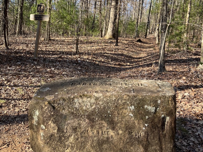
| Event Directions: | First of all, do not rely on GPS to get to this hike! You can follow GPS to Clayton, but if you rely on it after that you likely will miss the hike. Second, you will need a relatively high-clearance vehicle. I was easily able to navigate it in a Subaru Outback, and think most cars with at least 7" clearance likely will do fine. But, third, the speed limit on the gravel roads is 10 mph, and if you go faster you may not miss big rocks and ruts. From US 441/GA 23 North, just after you pass US 76 turn right on Warwoman Road. Follow Warwoman Road for 9 miles, then as you go downhill down a right turn, turn left on Saras Creek Road. Follow Saras Creek Road for 2 miles. It begins as a paved road, but after about half a mile it becomes a gravel road. You will cross Saras Creek on a small bridge, then take an immediate left onto Forest Road 155. The sign had been damaged and was unreadable when I was there recently. Follow FR 155 for 9 miles. It is a LONG 9 miles, especially if you follow my advice and don't exceed the 10 mph speed limit. But it's part of the adventure of this hike! At about 9 miles you will see a rectangular stone that marks the trail (see the photo above). There is parking for 2 or 3 cars on the left (don't park in the adjacent trail or campsite). If the gravel road turns to dirt and mud you have passed the trail. Stop immediately and return to the gravel! | ||||
| Notes: | |||||
|
Here is the route we will take: * We encourage all members to follow our Etiquette Guidelines while participating in AOC events. | |||||
Cancellation/Partial Attendance: Please review the AOC cancellation policy. | |||||
 Calendar of Events
 Event Places