 Print-Friendly Version Print-Friendly Version
|
|
Apple Festival Weekend on Conasauga Creek | |||||
| The Basics: | |||||
| Event Type: | Camping | ||||
| Event Location: |
Mountaintown near Ellijay


| ||||
| Date(s) & Time: | Fri, Oct 17 2025 5:00 pm >> Sun, Oct 19 2025 9:00 pm | ||||
| Registration Opens: | Wed, Apr 9 2025 7:45 am | ||||
| Registration Cut Off: | Thu, Oct 16 2025 7:00 pm | ||||
| Event Duration: | 2 Days 4 Hours | ||||
| Difficulty Rating: | D1: Easy | ||||
| Pace: | Leisurely | ||||
| Trip Leader(s): | Mark Email Trip Leader(s) Email Trip Leader(s)
You must be logged in to get the Trip Leader contact information. | ||||
| Member Cost: | $12.00/Person (See Detailed Cost Info Below) | ||||
| Participant Info: | |||||
| Who's Invited: | Members Only, 21 And Older Only | ||||
| Maximum Group Size: | 65 | ||||
| Minimum Group Size: | 4 | ||||
| Number Registered So Far: | 32 / 0 (To see who's signed up, log in to the Member Area) | ||||
| Are Dogs Permitted: | Yes | ||||
| Itinerary: | |||||
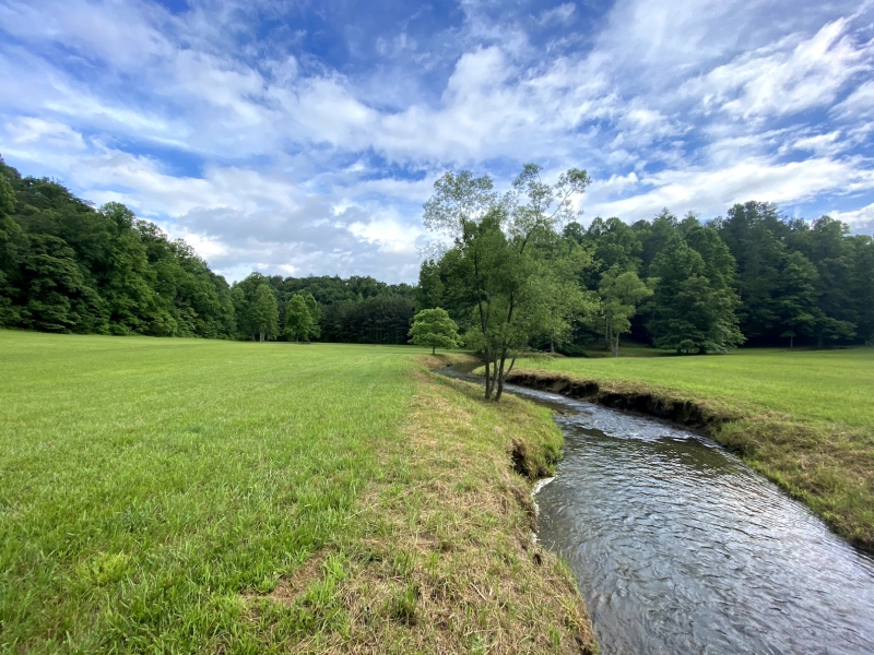
Join us for a weekend of camping where the beautiful Conasauga Creek winds through green pastures near the Cohutta Wilderness. Separate hiking events will be planned for Friday, Saturday, and Sunday. Those who don't hike may relax around the picnic shelter or explore the Apple Festival and other activities in nearby Ellijay. Come and go as you please. Participate in the entire weekend, spend a single night, or drop in to visit. The hiking events and itineraries have not yet been set, but several nearby hikes ranging from D1 to D5 are under consideration. These include hikes in Rich Mountain Wilderness, Fort Mountain, Emery Creek Trail, routes in the Cohutta Wilderness, and Bear Creek Trail (D1, D2). Trip leaders should contact Mark Bowden if interested in planning and leading a hike. Amenities: With acres of green fields set along Conasauga Creek, there is plenty of room to set up tents or small campers. The location features a large picnic shelter with lighting and electricity. There is a privy about 200 feet from the camping area. Farther away, there is also access to the basement of the host's home, where campers are welcome to use the bathroom and shower. Click this link for shared Google photos of the event site. https://photos.app.goo.gl/2EkD3zGrk14eErb69 | |||||
| |||||
| How to Get There: | |||||
| Event Directions: | Starting from I-575 at Hwy 92 in Woodstock Follow I-575 N and GA-5 N/GA-515 N/State Rte 515 N to 1st Ave/Soule Bridge in East Ellijay (48.3 miles) Turn Left on 1st Avenue and cross bridge. Turn left on River Street / Hwy 52 West and go 0.9 miles to traffic circle. Take 2nd exit of traffic circle on Hwy 2 / Hwy 52 and go 8 miles to Mountain Town Road (Look for Mountaintown Baptist Church Sign on left) Turn Left on Turn Left of Mountaintown Road and proceed short distance to Mountaintown Baptist Church. Turn Right on unpaved Maple Rest Road, just before Mountaintown Baptist Church. Turn left on Canaan Road and drive up the hill. Granny's house with concrete paved driveway and stone entrance sign "The Promised Land" is on top of the hill on the left. Continue straight on Canaan Road past Granny's House, descending steeply on newly graded section of road. At the bottom of the hill, turn left into the pasture. Do not drive across the narrow concrete bridge at the bottom of the hill. Drive to the far end of the pasture where you will see the picnic shelter. The loading and unloading area will be near the picnic shelter. Cars should then proceed to the parking area. We will keep vehicles separate from campers. First arrivals may park at the designated area beyond the picnic shelter and to the left. Overflow parking will be near Canaan Road at the entrance to the field. Google Directions: https://maps.app.goo.gl/i5DiELe8dynrt6a69 Google directions use Mountaintown Road (about a mile before the directions given above. This is followed by a right onto Maple Rest Lane, then left onto Canaan Road. | ||||
| Notes: | |||||
|
If you plan on bringing a camper, please text Mark Bowden at 404-718-9839. We will need to discuss road conditions to determine whether your camper is suitable for entry and egress. For safety reasons, we will keep vehicles away from the tenting area. Parking will be near the entrance of the field. Drive to the picnic shelter area for loading and unloading. For safety reasons, we will keep vehicles away from the tenting area. Please complete loading and unloading before dark. We want to keep all vehicles away from camping and eating areas after dark. Setup Areas: Areas will be marked with signs and surveyors' tape. The immediate area around the Picnic Shelter down to the creek, including the fire ring will be reserved for gathering activites, dining, and food preparation. Campers or those sleeping in their vehicle should set up at the end of the field before entering the wooded area surrounding the picnic shelter. Tenting is in the open area beyond the picnic shelter. Smaller tents one and two-person-sized tents may be set up in the trees between the Picnic Shelter and the camper area. Hammocks may be strung in any trees that won't obstruct pedestrian and vehicle traffic. There are a number of spaced-out trees on both sides of the picnic shelter. Important information for paid events in which payment is managed through the AOC: - Payment must be received by the payment due date and prior to participation in the event. - Some paid events require a minimum number of registered participants. If that number is not met, the event will be canceled and refunds will be issued to those who have already paid. - Third-party vendors often require damage deposits. Each registrant agrees to be liable for and required to reimburse the Atlanta Outdoor Club for any withheld deposits due to the actions of or damages caused by that registrant. - No partial payments. All registrants must pay the posted Member Cost regardless of any agreement you may have with any party involved in the event. - Read the event description carefully for additional information, and contact the trip leader(s) with any questions. * We encourage all members to follow our Etiquette Guidelines while participating in AOC events. | |||||
| Cost & Payment: | |||||
| Member Cost: | $12.00/Person | ||||
| Cost Includes: | $10 to cover the cost of rental of 2 Porta Toilets to supplement bathroom facilities. $2 for AOC paid event fee where paid event is less than $20 | ||||
| Payment Cut Off: | Payment must be received by the AOC on Thu, Oct 16 2025. | ||||
| Make a Payment: | Click here for the details. PLEASE PAY AFTER YOU HAVE SIGNED UP BELOW. | ||||
Cancellation/Partial Attendance: Please review the AOC cancellation policy. | |||||
 Calendar of Events
 Event Places