 Print-Friendly Version Print-Friendly Version
|
|
Blood Mountain via Slaughter Creek | |||||||
| The Basics: | |||||||
| Event Type: | Hike | ||||||
| Event Location: |
Lake Winfield Scott


| ||||||
| Date(s) & Time: | Wed, May 21 2025 10:00 am >> Wed, May 21 2025 3:15 pm (Carpool Departure: 7:45 am *log in for location*) | ||||||
| Registration Opens: | Wed, May 14 2025 8:00 pm | ||||||
| Registration Cut Off: | Tue, May 20 2025 8:00 pm | ||||||
| Event Duration: | 5 Hours 15 Minutes | ||||||
| Difficulty Rating: | D4: Moderate to Difficult | ||||||
| Distance: | 8 Miles | ||||||
| Pace: | Moderate | ||||||
| Trip Leader(s): | Joyce B. Wayne  Email Trip Leader(s) Email Trip Leader(s)
You must be logged in to get the Trip Leader contact information. | ||||||
| Member Cost: | None | ||||||
| Participant Info: | |||||||
| Who's Invited: | Members Only, 21 And Older Only | ||||||
| Maximum Group Size: | 10 | ||||||
| Minimum Group Size: | 4 | ||||||
| Number Registered So Far: | 10 / 0 (To see who's signed up, log in to the Member Area) | ||||||
| Are Dogs Permitted: | No | ||||||
| Itinerary: | |||||||
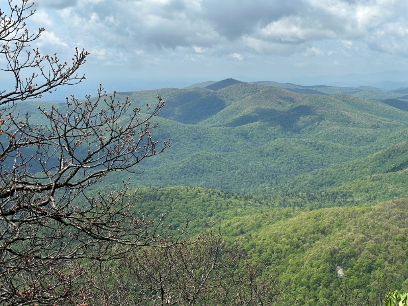
Join us for a moderate paced hike to the iconic Blood Mountain peak, 4500 feet, the highest on the Appalachian Trail in Georgia. Expect 2.3-2.5 mph. Elevation gain of 1,900'. Pack your lunch to enjoy atop Picnic Rock, with a surprising view of downtown Atlanta 70 miles away. I will bring binoculars if you want a closer look. At the peak there is an interesting stone shelter, one of the rare deluxe two-room models, built by the CCC in 1934. Up top there is also a porta potty. We are going on a weekday hoping for minimal crowds. We're hiking up the "backside " from Lake Winfield Scott where there is ample parking if you choose to drive although a carpool is also being arranged. If you do drive remember to bring your National Park Pass or cash to pay daily access fee. We will go up and back on the Slaughter Creek Trail, about 4 miles each way. Slaughter Creek is much more scenic than the Jarrard Gap Loop option, IMHO. On the way we'll talk about the origins of the eerie place names, and who Winfield Scott was. We'll pass photo opps for mayapples currently in bloom, as well as foam flowers and wild Irises, and cross several streams, or is it one stream several times? You decide. | |||||||
| |||||||
| How to Get There: | |||||||
| Event Directions: | From Indian Trail Park and Ride: take I-85N to I-985, then take GA Hwy 60 toward Dahlonega 42 miles to Suches, GA, turn rt on GA 180 and follow signs to Lake Winfield Scott. On left, before the lake, is trailhead parking. No cell service after you leave Suches. From North Atlanta: take 400 north, that becomes US 19. That will join up with GA 60 below Dahlonega. Then follow the GA 60 directions above. | ||||||
| Carpool to Event Distance (round trip): | 155Mile(s) | ||||||
| Carpool Departure Time: | 7:45 am | ||||||
| Carpool Location: | Log in for location | ||||||
| Carpool Directions: | Log in for directions | ||||||
| Carpool Cost: | Estimated cost per vehicle for this event is $62.00 using a reimbursement rate guideline of $0.400 per mile. The total amount should be divided by the number of people in the vehicle, including the driver. This is a guideline, not a rule, for drivers but the cost should not be higher unless there are extenuating circumstances. | ||||||
| Notes: | |||||||
|
* We encourage all members to follow our Etiquette Guidelines while participating in AOC events. | |||||||
Cancellation/Partial Attendance: Please review the AOC cancellation policy. | |||||||
 Calendar of Events
 Event Places