 Print-Friendly Version Print-Friendly Version
|
|
From Cochran Shoals/Interstate North to Sope Creek | |||||||
| The Basics: | |||||||
| Event Type: | Hike | ||||||
| Event Location: |
Cochran Shoals Trailhead - Interstate North - NOT Columns Drive Entrance


| ||||||
| Date(s) & Time: | Tue, May 20 2025 9:00 am >> Tue, May 20 2025 12:30 pm | ||||||
| Registration Opens: | Wed, May 14 2025 6:00 pm | ||||||
| Registration Cut Off: | Tue, May 20 2025 8:00 am | ||||||
| Event Duration: | 3 Hours 30 Minutes | ||||||
| Difficulty Rating: | D2: Easy to Moderate (Exploratory) | ||||||
| Distance: | 8.7 Miles | ||||||
| Pace: | Moderate | ||||||
| Trip Leader(s): | Gerrilyn Email Trip Leader(s) Email Trip Leader(s)
You must be logged in to get the Trip Leader contact information. | ||||||
| Member Cost: | None | ||||||
| Participant Info: | |||||||
| Who's Invited: | Members Only, 21 And Older Only | ||||||
| Maximum Group Size: | 12 | ||||||
| Minimum Group Size: | 3 | ||||||
| Number Registered So Far: | 6 / 0 (To see who's signed up, log in to the Member Area) | ||||||
| Are Dogs Permitted: | Yes | ||||||
|
Note: This is an "EXPLORATORY" trip. This means that there are parts of this trip, or perhaps the whole trip, that is new to your Trip Leader(s). However, they are confident that this will not be an issue. This note is here so that you can make an informed decision. When a Trip Leader isn't personally familiar with a trip, there is an increased chance of things not going as planned and you need to be prepared. The Trip Leader may have additional details in the itinerary. | |||||||
| Itinerary: | |||||||
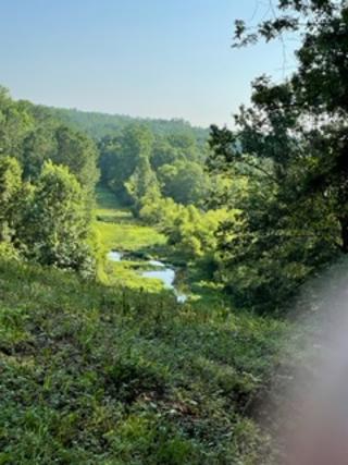
Please join me on a beautiful hike that connects two different units of the CRNRA. We will hike from Cochran Shoals to Sope Creek and back. This hike will be a moderate pace with stops as needed. This hike is on the high end of D2. It has enough mileage for a D3 but not enough elevation gain. Because of the distance covered this is not a hike for beginners. Please arrive a few minutes early for introductions. We will stop along the way for a group photo. In total we will cover about 8.7 miles and about 630 feet of elevation. The time given for the duration of the hike and the distance covered are approximate. For part of the hike we will be on trails that allow mountain bikers. But the we will be going in the opposite direction of the bikers so we will see them coming. We will be fine if we stay to the right. Wear bright colors for more safety. There are some rooty, rocky and muddy areas. There are also areas with poison ivy on the sides of the trail so you may want to wear long pants. Hiking poles would be helpful. A CRNRA pass on your car is required. One day fee is $5.00 Or you can buy an annual pass for $40.00, If you do not have a pass you can purchase one online at nps.gov/chat/planyourvisit/fees.htm. You can also buy a pass using a QR code sign in the parking lot, There are bathrooms at the trailhead. | |||||||
| |||||||
| How to Get There: | |||||||
| Event Directions: | The official address is 1956 Eugene Gunby Road. That address works on Google Maps and Waze. If you are driving south on Powers Ferry in East Cobb make a left turn at Interstate North Parkway before going under 285. Then make a left turn in about a half mile just before the river into the parking lot. This is NOT the entrance at the end of Columns Drive which also is called the Cochran Shoals Trail. This is NOT the parking lot for Powers Island which is on the other side of the river. We will start at the Cochran Shoals trailhead off of Interstate North just north of I-285.
coordinates 33.90233, -84.44428 | ||||||
| Notes: | |||||||
|
There are bathrooms at the trailhead. CRNRA Parking pass required. * We encourage all members to follow our Etiquette Guidelines while participating in AOC events. | |||||||
Cancellation/Partial Attendance: Please review the AOC cancellation policy. | |||||||
 Calendar of Events
 Event Places