 Print-Friendly Version Print-Friendly Version
|
|
Bartram Trail to Rabun Bald | |||||||
| The Basics: | |||||||
| Event Type: | Hike | ||||||
| Event Location: |
Bartram Trail at Hale Ridge Road,, near Clayton, GA


| ||||||
| Date(s) & Time: | Tue, Sep 16 2025 9:00 am >> Tue, Sep 16 2025 2:00 pm (Carpool Departure: 7:00 am *log in for location*) | ||||||
| Registration Opens: | Thu, Sep 4 2025 7:00 am | ||||||
| Registration Cut Off: | Sun, Sep 14 2025 6:00 pm | ||||||
| Event Duration: | 5 Hours | ||||||
| Difficulty Rating: | D4: Moderate to Difficult | ||||||
| Distance: | 8 Miles | ||||||
| Pace: | Moderate | ||||||
| Trip Leader(s): | Chuck M Email Trip Leader(s) Email Trip Leader(s)
You must be logged in to get the Trip Leader contact information. | ||||||
| Member Cost: | None | ||||||
| Participant Info: | |||||||
| Who's Invited: | Members Only, 21 And Older Only | ||||||
| Maximum Group Size: | 10 | ||||||
| Minimum Group Size: | 3 | ||||||
| Number Registered So Far: | 8 / 0 (To see who's signed up, log in to the Member Area) | ||||||
| Are Dogs Permitted: | No | ||||||
| Itinerary: | |||||||
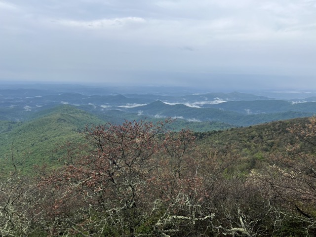
Come join me on a "less rigorous" hike to Rabun Bald, one of my favorite destinations in Georgia. I usually list this as a D5, but am doing a shorter version to give people a chance to experience the fantastic views from Rabun Bald, the second highest point in Georgia. While this route is less difficult that my usual routes, it is still very hard. We will climb about 2,260 feet over 8 miles, some of it very steep. But the views are spectacular, well worth the climb! We will begin where the Bartram Trail crosses Hale Ridge Road, about 30 minutes from the Clayton Ingles. From there we will hike south on the Bartram Trail to Rabun Bald. At Rabun Bald we will ascend the stone tower to the wooden deck with fabulous views into Georgia, South Carolina, North Carolina, Tennesee, and maybe even Alabama. We will have a snack/lunch break at Rabun Bald before returning to the trailhead. The Bartram Trail is a beautiful, well maintained trail that is far less travelled than our beloved AT. So we are likely to enjoy some solitude on this hike. Here is a map of the hike: | |||||||
| |||||||
| How to Get There: | |||||||
| Event Directions: | Parking at the trailhead is limited, so we will squeeze into the fewest cars possible. Because the trailhead has such limited parking, do not go directly to the trailhead! You must either join the carpool at Indian Trail Park and Ride or meet us at the Ingles in Clayton. From the Carpool we will drive to the Ingles in Clayton, where we can use the restrooms and pick up lunch if desired. If you type "Ingles Clayton" into your GPS (Google or Apple Maps) it will take you to the right place. Here is a link for Google Maps: https://goo.gl/maps/foL9trA5N VQJxApt5 Park on the right side of the parking lot, and take advantage of the clean restrooms in Ingles (there are no facilities on this hike). You might also consider buying something for lunch. Here we will transfer into two cars. Meeting at the trailhead is not allowed due to the limited parking. Please arrive at the Clayton Ingles by 8:40 so we can depart for the trailhead at 9. | ||||||
| Carpool to Event Distance (round trip): | 194Mile(s) | ||||||
| Carpool Departure Time: | 7:00 am | ||||||
| Carpool Location: | Log in for location | ||||||
| Carpool Directions: | Log in for directions | ||||||
| Carpool Cost: | Estimated cost per vehicle for this event is $77.60 using a reimbursement rate guideline of $0.400 per mile. The total amount should be divided by the number of people in the vehicle, including the driver. This is a guideline, not a rule, for drivers but the cost should not be higher unless there are extenuating circumstances. | ||||||
| Notes: | |||||||
|
We will travel together to the trailhead. It takes about 30 minutes to get there from Ingles. The GPS coordinates for the trailhead are 34.99564° N, 83.28187° W. NOTE: Meeting at the trailhead is not allowed due to the very limited parking available. * We encourage all members to follow our Etiquette Guidelines while participating in AOC events. | |||||||
Cancellation/Partial Attendance: Please review the AOC cancellation policy. | |||||||
 Calendar of Events
 Event Places