 Print-Friendly Version Print-Friendly Version
|
|
Cumberland Trail - North Chickamauga Creek | |||||||
| The Basics: | |||||||
| Event Type: | Hike | ||||||
| Event Location: |
Soddy Daisy, Tn


| ||||||
| Date(s) & Time: | Sun, Oct 5 2025 8:30 am >> Sun, Oct 5 2025 4:00 pm (Carpool Departure: 7:00 am *log in for location*) | ||||||
| Registration Opens: | Sun, Sep 21 2025 6:00 pm | ||||||
| Registration Cut Off: | Sat, Oct 4 2025 6:00 pm | ||||||
| Event Duration: | 7 Hours 30 Minutes | ||||||
| Difficulty Rating: | D5: Difficult | ||||||
| Distance: | 12 Miles | ||||||
| Pace: | Moderate | ||||||
| Trip Leader(s): | Leigh B Email Trip Leader(s) Email Trip Leader(s)
You must be logged in to get the Trip Leader contact information. | ||||||
| Member Cost: | None | ||||||
| Participant Info: | |||||||
| Who's Invited: | Members Only, 21 And Older Only | ||||||
| Maximum Group Size: | 10 | ||||||
| Minimum Group Size: | 3 | ||||||
| Number Registered So Far: | 3 / 0 (To see who's signed up, log in to the Member Area) | ||||||
| Are Dogs Permitted: | Yes | ||||||
| Itinerary: | |||||||
Credit to Ron J for original write up and map
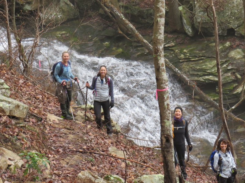
North Chickamauga Creek
This section is filled with difficult terrain, waterfalls, gorges, rapids, creek crossings and awesome vistas.
If you are looking for a hike on an iconic trail with tons of cool stuff to see, this is your hike! We will be stopping at all points of interest for picture taking and high hilarity. This is an out and back hike.
We will be starting at Montlake Trailhead and head north. We will head to the Boston Branch Overlook followed by a steep descent to the Stenenson Branch Falls. After the falls we will hike along the bottom of the Cooper Creek Gorge where we can see waterfalls, plunge pools and steep cliffs. We ascend out of the gorge and shortly reach the Panther Branch Overlook. Here we will stop for lunch and enjoy the best views of the day. After lunch we will retrace our steps to complete our out and back adventure. We will be fording one creek with water levels expected to be ankle-waist deep, you should bring water shoes for the crossing or be prepared to hike with wet feet.
This is a 12 mile hike with 2500 feet of ascent. Some of the terrain is steep and difficult, the hardest ascent of the hike occurs at the 10 mile point. Don't be fooled by the fairly pedestrian numbers for this hike. It is REALLY difficult. This hike feels like a D6 due to the extremely steep and rocky terrain.
You must have recent D5 experience, be comfortable with a pace of 2.5 to 2.7 mph. and be prepared for difficult terrain to participate in this event. Weekend D5 rosters can bring different levels of ability. As a TL, I insist on keeping the group together so please only sign up if you are willing to keep pace. (even if you are usually faster)
There are no bathrooms at the trailhead.
| |||||||
| |||||||
| How to Get There: | |||||||
| Event Directions: | We will meet at the trailhead at 8:30 EASTERN!
| ||||||
| Carpool to Event Distance (round trip): | 214Mile(s) | ||||||
| Carpool Departure Time: | 7:00 am | ||||||
| Carpool Location: | Log in for location | ||||||
| Carpool Directions: | Log in for directions | ||||||
| Carpool Cost: | Estimated cost per vehicle for this event is $85.60 using a reimbursement rate guideline of $0.400 per mile. The total amount should be divided by the number of people in the vehicle, including the driver. This is a guideline, not a rule, for drivers but the cost should not be higher unless there are extenuating circumstances. | ||||||
| Notes: | |||||||
|
* We encourage all members to follow our Etiquette Guidelines while participating in AOC events. | |||||||
Cancellation/Partial Attendance: Please review the AOC cancellation policy. | |||||||
 Calendar of Events
 Event Places