 Print-Friendly Version Print-Friendly Version
|
|
Double D2s in Forsyth / Gwinnett - Laurel Ridge Trail at Buford Dam | |||||||
| The Basics: | |||||||
| Event Type: | Hike | ||||||
| Event Location: |
Buford


| ||||||
| Date(s) & Time: | Sat, Nov 29 2025 9:00 am >> Sat, Nov 29 2025 11:00 am | ||||||
| Registration Opens: | Sun, Nov 23 2025 8:00 am | ||||||
| Registration Cut Off: | Fri, Nov 28 2025 8:00 pm | ||||||
| Event Duration: | 2 Hours | ||||||
| Difficulty Rating: | D2: Easy to Moderate | ||||||
| Distance: | 4.2 Miles | ||||||
| Pace: | Moderate | ||||||
| Trip Leader(s): | Jerry K Stacey Johnson  Email Trip Leader(s) Email Trip Leader(s)
You must be logged in to get the Trip Leader contact information. | ||||||
| Member Cost: | None | ||||||
| Participant Info: | |||||||
| Who's Invited: | Members Only, 21 And Older Only | ||||||
| Maximum Group Size: | 12 | ||||||
| Minimum Group Size: | 3 | ||||||
| Number Registered So Far: | 8 / 0 (To see who's signed up, log in to the Member Area) | ||||||
| Are Dogs Permitted: | No | ||||||
| Itinerary: | |||||||
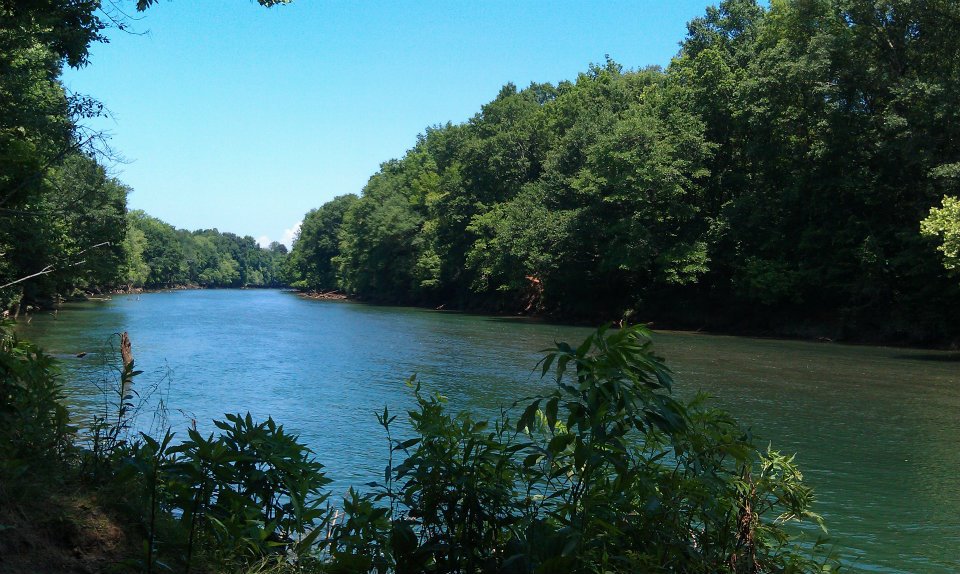
Join us as we explore the Laurel Ridge Trail. The trail follows parts of both the Chattahoochee and Lake Lanier. It is a very scenic hike that includes wooded areas as well as water views. We will be moving at a moderate pace throughout, there is a good chance we will finish before the posted time, but we are open to stopping along the way for taking in the views. This is not a fast paced or fitness hike. We will meet in the parking lot at the Lower Overlook park bathrooms and begin hiking at 9:00 am. We will take the trail from the parking lot and kike toward The Chattahoochee to start. We will be stopping briefly at scenic areas to enjoy the view depending on the wishes of the group. Dogs are not permitted per Lake Lanier /A rmy Corp Authority. Directly following the hike we will go to Haw Creek Park and hike the multiuse trail there. Please see second event post for details. Dogs are allowed at Haw Creek. | |||||||
| |||||||
| How to Get There: | |||||||
| Event Directions: | From I85, head north and take the I 985 exit. Continue a little under 4 miles on I 985 until Exit 4. At the top of the ramp take a left onto SR 20. Proceed about 5.5 miles on SR 20 and take a right onto Suwanee Dam Road, which dead ends after 2.2 miles when it reaches Buford Dam Road. Take a left onto Buford Dam Road, and proceed 1 mile. The Lower Overlook parking will be on your right. If you reach Buford Dam you have gone too far. From 400 - exit 14, go east to Samples Rd. Turn left on Samples and follow to Buford Dam rd. Turn right onto Buford Dam and continue east. immediately after crossing the dam look for Lower Overllok parking on your left. | ||||||
| Notes: | |||||||
|
This hike will be the 1st for the day. We will be Hiking Haw Creek after this hike and having lunch after Haw Creek. Please join us for both! * We encourage all members to follow our Etiquette Guidelines while participating in AOC events. | |||||||
Cancellation/Partial Attendance: Please review the AOC cancellation policy. | |||||||
 Calendar of Events
 Event Places