
 Print-Friendly Version Print-Friendly Version
|
|
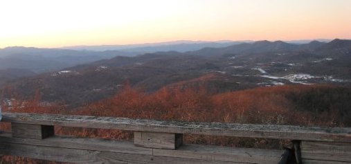
Sunset on Rabun Bald | |||||||||
| The Basics: | |||||||||
| Event Type: | Hike | ||||||||
| Event Location: | Chattahoochee National Forest | ||||||||
| Date(s) & Time: | Sat, Dec 4 2010 6:45 am >> N/A (Carpool Departure: 7:00 am *log in for location*) | ||||||||
| Registration Opens: | Mon, Nov 1 2010 9:30 pm | ||||||||
| Registration Cut Off: | Wed, Dec 1 2010 9:30 pm | ||||||||
| Event Duration: | Per Itinerary | ||||||||
| Difficulty Rating: | D5: Difficult | ||||||||
| Trip Leader(s): | Tanja B Email Trip Leader(s) Email Trip Leader(s)
You must be logged in to get the Trip Leader contact information. | ||||||||
| Member Cost: | None | ||||||||
| Participant Info: | |||||||||
| Who's Invited: | Members Only, 21 And Older Only | ||||||||
| Maximum Group Size: | 15 | ||||||||
| Minimum Group Size: | 4 | ||||||||
| Number Registered So Far: | 11 / 0 (To see who's signed up, log in to the Member Area) | ||||||||
| Are Dogs Permitted: | No | ||||||||
| Itinerary: | |||||||||
| Standing 4696' above sea level with 1016 feet of clean prominence, Rabun Bald is the 2nd tallest in GA. The open, wooden observation platform at the top provides one of the best views in the state. On a clear day you can see Tray mtn, Mt Yonah, Big Scaly Mtn, Standing Indian and many other GA/NC/SC peaks. We will start at Warwoman Dell picnic area where we'll jump on the Bartram Trail. We'll hike by Becky Branch Falls and the larger more impressive Martins Creek Falls. Then it is some rolling terrain as we slowly gain in elevation over the 14 miles to the summit of Rabun Bald. The gaps are not that deep. There is an excellent overlook near Flat Top Mtn and then of course the views from the top of Rabun Bald, where we'll take a long break. Sunset is at 5:22pm. To get to the summit by sunset we'll have to average at least 2.5 mph on the leading 14-mile climb. If we time it right and the weather cooperates, we will hang around the observation deck until the sun has set. From the top of Rabun Bald it's another 4 miles downhill to the cars. It will be dark before we get to the cars, so be sure to bring a flashlight or headlamp. As it is late in the year, it may be a bit chilly at the top. If this is the case, the trip leader might have a stove in her backpack to heat some water for tea or the like if we reach the observation platform early enough to wait a while for the sun to set. Warwoman picnic area to Hale Ridge Road via Bartram Trail Distance: 18 miles Total ascent: 4300' NOTE: This is a *long*, difficult hike and a long day with all the driving. This is NOT a beginner hike and I will be contacting people whose abilities I do not know. Those who are interested will have dinner in Clayton, but even without a dinner stop don't expect to be back at the carpool before about 9:45pm.  | |||||||||
| How to Get There: | |||||||||
| Event Directions: | Directions to trailhead will be given at carpool (or via email if "meeting at event"). | ||||||||
| Carpool to Event Distance (round trip): | 214Mile(s) | ||||||||
| Carpool Departure Time: | 7:00 am | ||||||||
| Carpool Location: | Log in for location | ||||||||
| Carpool Directions: | Log in for directions | ||||||||
| Carpool Cost: | Estimated cost per vehicle for this event is $85.60 using a reimbursement rate guideline of $0.400 per mile. The total amount should be divided by the number of people in the vehicle, including the driver. This is a guideline, not a rule, for drivers but the cost should not be higher unless there are extenuating circumstances. | ||||||||
| Notes: | |||||||||
* We encourage all members to follow our Etiquette Guidelines while participating in AOC events. | |||||||||
Cancellation/Partial Attendance: Please review the AOC cancellation policy. | |||||||||
 Calendar of Events
 Event Places