 Print-Friendly Version Print-Friendly Version
|
Jones Bridge CRNRA | |||||||
| The Basics: | |||||||
| Event Type: | Hike | ||||||
| Event Location: |
Jones Bridge Trail


| ||||||
| Date(s) & Time: | Tue, Jan 20 2026 10:00 am >> Tue, Jan 20 2026 12:30 pm | ||||||
| Registration Opens: | Thu, Jan 15 2026 4:00 pm | ||||||
| Registration Cut Off: | Tue, Jan 20 2026 7:00 am | ||||||
| Event Duration: | 2 Hours 30 Minutes | ||||||
| Difficulty Rating: | D2: Easy to Moderate | ||||||
| Distance: | 5.8 Miles | ||||||
| Pace: | Leisurely | ||||||
| Trip Leader(s): | Drew W Email Trip Leader(s) Email Trip Leader(s)
You must be logged in to get the Trip Leader contact information. | ||||||
| Member Cost: | None | ||||||
| Participant Info: | |||||||
| Who's Invited: | Members Only, 21 And Older Only | ||||||
| Maximum Group Size: | 15 | ||||||
| Minimum Group Size: | 4 | ||||||
| Number Registered So Far: | 13 / 0 (To see who's signed up, log in to the Member Area) | ||||||
| Are Dogs Permitted: | No | ||||||
| Itinerary: | |||||||
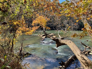
Jones Bridge is one of the easier hikes in the CRNRA. The trails along the river are flat with several great views of the river, fishermen. The inland trails are well maintained and mostly free of roots. There are some moderate hills, the steepest of which is about 150 ft. The total elevation of this hike is about 260 feet. There are bathrooms at the trail head. Please arrive by 10:50 for introductions. You will needs CRNA parking pass but I think you can buy a parking pass at the kiosk. The hike will start promptly at 10:00. CRNRA daily pass is $5. Annual pass is $40. Parking passes can be purchased online at https: //www.nps.gov/c hat/planyourvisit/fees.htm. Daily passes can be purchased on site. No cash accepted. | |||||||
| |||||||
| How to Get There: | |||||||
| Event Directions: | Traveling west on Holcomb Bridge Rd, turn right onto Barnwell Rd. Traveling east on Holcomb Bridge Rd, turn left onto Barnwell Rd. Drive past the Environmental Education Center. Turn right into the park at the National Park Service sign for Jones Bridge CRNRA. Traveling west on Old Alabama Rd, turn left onto Jones Bridge Rd. Traveling east on Old Alabama Rd, turn right onto Jones Bridge Rd. Jones Bridge will turn into Barnwell at the right angle curve. Turn left into the park at the National Park Service sign for Jones Bridge CRNRA. When you enter the park, drive to the parking lot at the end of the road. I don't believe there is an actual street address, so follow the directions carefully, or use the GPS coordinates below. GPS Coordinates: 34.00093610490775, -84.23941734966813 | ||||||
| Notes: | |||||||
|
*** Do not leave any valuables in your car. There have been reports of vandalism. *** Please allow for extra time if you plan to purchase a parking pass on site or use the restroom before the hike * We encourage all members to follow our Etiquette Guidelines while participating in AOC events. | |||||||
Cancellation/Partial Attendance: Please review the AOC cancellation policy. | |||||||
 Calendar of Events
 Event Places