 Print-Friendly Version Print-Friendly Version
|
|
Views Galore to Rabun Bald | |||||||
| The Basics: | |||||||
| Event Type: | Hike | ||||||
| Event Location: |
Ingles in Clayton, GA


| ||||||
| Date(s) & Time: | Sat, May 16 2026 8:30 am >> Sat, May 16 2026 3:30 pm (Carpool Departure: 7:00 am *log in for location*) | ||||||
| Registration Opens: | Fri, May 1 2026 6:00 am | ||||||
| Registration Cut Off: | Thu, May 14 2026 9:00 pm | ||||||
| Event Duration: | 7 Hours | ||||||
| Difficulty Rating: | D5: Difficult | ||||||
| Distance: | 14 Miles | ||||||
| Pace: | Moderate | ||||||
| Trip Leader(s): | Dan Gilroy Greg Pharo  Email Trip Leader(s) Email Trip Leader(s)
You must be logged in to get the Trip Leader contact information. | ||||||
| Member Cost: | None | ||||||
| Participant Info: | |||||||
| Who's Invited: | Members Only, 21 And Older Only | ||||||
| Maximum Group Size: | 10 | ||||||
| Minimum Group Size: | 3 | ||||||
| Number Registered So Far: | 9 / 0 (To see who's signed up, log in to the Member Area) | ||||||
| Are Dogs Permitted: | No | ||||||
| Itinerary: | |||||||
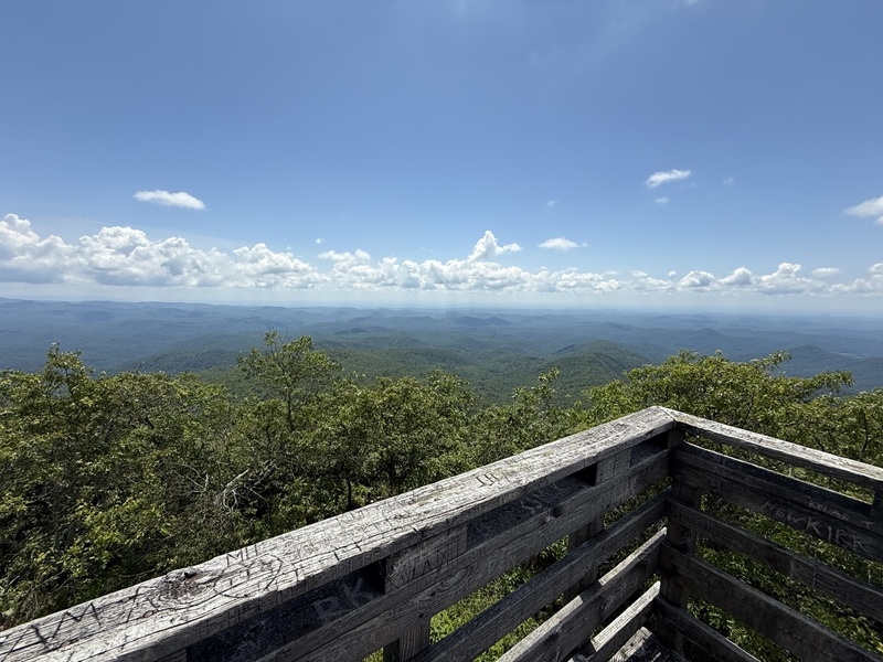
This is a perfect time of year for a hike to the second highest point in Georgia. Rabun Bald offers great views from the observation tower making the strenuous hike well worth the effort. We will be hiking from Darnell Creek to the Bartram trail and then continue our climb to Rabun Bald with several great viewing areas along the way. When we reach the bald, we will stop for lunch at the observation tower. After lunch and spending some time taking in the view of several states, we will make our way back to the cars using the standard route. This is an out and back hike that plans out on All Trails as 14 miles and just over 3,000 feet of elevation gain. All Trails is not always accurate and other leaders have listed this as 15 miles so be prepared. Given the rigor we will take a slower pace around 2.6 MPH. This is however a D5 hike and we want to make sure everyone has fun, so prior D5 experience is going to be required. If your experience is outside the club, I will move you to the waitlist and so you can provide links for your comparable hikes. There will be water crossings on this hike. Depending on the current rain and conditions this could be up to shin deep so bring your water shoes and poles if you want to use them. Parking at the trailhead is EXTREMELY limited. For those who are not in the carpool we will be meeting in Clayton at the Ingles and pile into two cars for the last couple of miles. The start time listed for this hike is the time we will meet at Ingles. We will load into two cars and head to the trailhead for a 9:00 start.
| |||||||
| |||||||
| How to Get There: | |||||||
| Event Directions: | We will meet at the Ingles in Clayton. If you type "Ingles Clayton" into your GPS (Google or Apple Maps) it will take you to the right place. Here is a link for Google Maps: https://maps.app.goo.gl/co5bHNYDioZqydmU8 Park on the right side of the parking lot, and take advantage of the clean restrooms in Ingles (there are no facilities on this hike). You might also consider buying something for lunch. Here we will transfer into two cars. Meeting at the trailhead is not allowed due to the limited parking. Please arrive at the Clayton Ingles by 8:40 so we can head to the trailhead around 9. | ||||||
| Carpool to Event Distance (round trip): | 178Mile(s) | ||||||
| Carpool Departure Time: | 7:00 am | ||||||
| Carpool Location: | Log in for location | ||||||
| Carpool Directions: | Log in for directions | ||||||
| Carpool Cost: | Estimated cost per vehicle for this event is $71.20 using a reimbursement rate guideline of $0.400 per mile. The total amount should be divided by the number of people in the vehicle, including the driver. This is a guideline, not a rule, for drivers but the cost should not be higher unless there are extenuating circumstances. | ||||||
| Notes: | |||||||
|
* We encourage all members to follow our Etiquette Guidelines while participating in AOC events. | |||||||
Cancellation/Partial Attendance: Please review the AOC cancellation policy. | |||||||
 Calendar of Events
 Event Places