 Print-Friendly Version Print-Friendly Version
|
|
The Georgia Loop-sorry, need to change the date! | |||||||
| The Basics: | |||||||
| STATUS: | Cancelled - Show on Calendar (until date passes) | ||||||
| Event Type: | Backpacking | ||||||
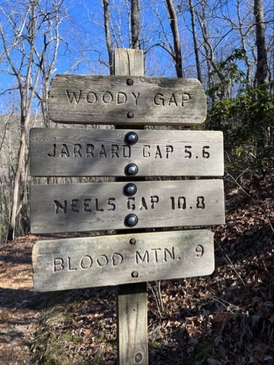
| Event Location: |
Woody Gap


| ||||||
| Date(s) & Time: | Thu, Apr 30 2026 8:00 am >> Sun, May 3 2026 5:00 pm | ||||||
| Registration Opens: | Wed, Apr 22 2026 7:00 am | ||||||
| Registration Cut Off: | Wed, Apr 29 2026 4:00 pm | ||||||
| Event Duration: | 3 Nights, 4 Days | ||||||
| Difficulty Rating: | D6: Advanced (Exploratory) | ||||||
| Distance: | 57 Miles | ||||||
| Pace: | Moderate | ||||||
| Trip Leader(s): | Chuck M Email Trip Leader(s) Email Trip Leader(s)
You must be logged in to get the Trip Leader contact information. | ||||||
| Member Cost: | None | ||||||
| Participant Info: | |||||||
| Who's Invited: | Members Only, 21 And Older Only | ||||||
| Maximum Group Size: | 1 | ||||||
| Minimum Group Size: | 5 | ||||||
| Number Registered So Far: | 1 / 0 (To see who's signed up, log in to the Member Area) | ||||||
| Are Dogs Permitted: | No | ||||||
|
Note: This is an "EXPLORATORY" trip. This means that there are parts of this trip, or perhaps the whole trip, that is new to your Trip Leader(s). However, they are confident that this will not be an issue. This note is here so that you can make an informed decision. When a Trip Leader isn't personally familiar with a trip, there is an increased chance of things not going as planned and you need to be prepared. The Trip Leader may have additional details in the itinerary. | |||||||
| Itinerary: | |||||||
The Georgia Loop is a well-known backpacking trip that is reputed to be the hardest one in Georgia. We will complete around 60 miles over four days of hiking, each day covering around 15 miles and climbing about 3,500 feet, with one day's climb over 4,000 feet. We will start at Woody Gap. The route uses the AT, the Duncan Ridge Trail, and the Benton McKaye Trail. While I think I've hiked everywhere we will hike, I list it as exploratory because I haven't done the loop all at one time. So the time noted above could be wrong. Because this is a difficult D6 backpacking trip, you will need to get on the waitlist first so I can verify that you have recent AOC activity that qualifies you for this trip. I will consider recent non-AOC experience if you send me a link to a recording (AllTrails, Strava, etc.). After adding people to the event I will try to facilitate a carpool. Day 1: Starting at Woody Gap we'll hike north on the AT for 8 rolling miles to the Duncan Ridge Trail (DRT) junction. The DRT is a rugged trail with some steep climbs and few switchbacks. We will turn onto the DRT and hike to Whiteoak Stomp Gap, where we will camp. Day 2: We will continue on the DRT most of the day before it joins the Benton McKaye trail. After about a half mile we will camp near Licklog Mouintain. Day 3: We'll spend most to the morning descending down the DRT/BMT to the Toccoa river for lunch. Then it's a long climb up Little and Big John Dick Mountains before a short descent down to Long Creek Falls where great campsites await along the creek. Day 4: From Long Creek camp it's a short walk to the AT. Turning north onto the AT the trail will be rolling with a tough climp up Sassafras Mtn, down to Justice Creek and Gooch Gap, then back up to Woody Gap finishing our adventure. Each day we will need to get an early start so we can complete the distance before we run out of daylight. You might want to consider spending the night before near the trailhead to make the first day easier. | |||||||
| |||||||
| How to Get There: | |||||||
| Event Directions: | Use these links to find the trailhead: Apple Maps: https://maps.apple/p/bb3de_xx_xLxq.z Google Maps: https://maps.app.goo.gl/BEbAfAxBXk7t2kcx7?g_st=ic | ||||||
| Notes: | |||||||
|
* We encourage all members to follow our Etiquette Guidelines while participating in AOC events. | |||||||
Cancellation/Partial Attendance: Please review the AOC cancellation policy. | |||||||
 Calendar of Events
 Event Places