Bushwhack Sweetwater! Part I: West Side of Sweetwater Creek
|
|
The Basics: |
| Event Type: |  | Explorer | |
|
Event Location: | |
Parking lot of Thornton Rd Walmart near I-20 Exit #44, W of Atlanta
| |
| Date(s) & Time: | | Fri, Feb 25 2011
9:30 am >> N/A (Carpool Departure: 9:30 am *log in for location*)
| |
| Registration Opens:
| |
Sat, Feb 19 2011 9:30 pm
| |
| Registration Cut Off:
| |
Thu, Feb 24 2011 9:30 pm
| |
| Event Duration: | | 5 to 6 Hours | |
| Difficulty Rating: | | D6: Advanced | |
Trip Leader(s):
| | Ryan Graham
Charlie Cottingham
Richard
 Email Trip Leader(s) Email Trip Leader(s)
You must be logged in to get the Trip Leader contact information.
| |
| Member Cost: | | None |
|
| Participant Info: |
| Who's Invited: | |
Members Only, 21 And Older Only
| |
| Maximum Group Size: | | 8 |
| Minimum Group Size: | | 3 |
| Number Registered So Far: | |
8 / 0 (To see who's signed up, log in to the Member Area)
|
| Are Dogs Permitted: | |
No
|
|
| Itinerary: |
Most of us know Sweetwater as it is described on the State Park's web site:
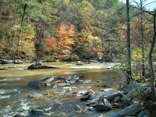
"Sweetwater Creek is a peaceful tract of wilderness only minutes from bustling downtown Atlanta. The most popular trail in the Park follows the free-flowing stream to the ruins of the New Manchester Manufacturing Company, a textile mill burned during the Civil War. Beyond the mill, this red-blazed trail climbs rocky bluffs to provide views of the beautiful mile-long stretch of white-water rapids below."
But not this time! For a major change of pace on this "explore" hike we'll venture into the seldom-traveled rugged back country of Sweetwater—much of it far from the heavily traveled Park trails. In this "Part I" adventure we'll focus on the west side of Sweetwater Creek and the territory between the "Red, White & Blue Trails" and the Chattahoochee River—generally south of the well-known portion of the Park.
The terrain adjoining Sweetwater Creek has about a 200-foot maximum elevation variation, and the hills are steep in some areas. Our uphill climbs will be rewarded by occasional nice views and photo-ops from atop the summits. Points of interest along the way will include a "hidden lake," a 6-foot waterfall, and an area of stunning natural disaster from the September 2009 floods.
This Hike will be paced chiefly by time, not miles, but please come willing to be flexible on both and eager to immerse yourself in the experience. Since we'll be "bushwhacking" along much of the route and also crossing a few shallow streams, we expect that our usual rate of progress will be slow to moderate. The hike is planned to last about 5 hours, plus or minus an hour or so—and our total distance covered may be as much as 9 to 12 miles. We'll assess how everyone is doing along the way, and will be happy to adjust our hike distance accordingly.
We'll access our trailhead from the South side of the Park via a small and relatively unknown gravel road. Due the small amount of parking space at that obscure trailhead, we require that everyone meet initially at the Thornton Road Walmart at 9:30 AM (detailed directions below) and carpool together to the trailhead, ideally in no more than 3 vehicles. Please come willing to drive or ride and be sure to pack plenty of water and snacks.
This event will be rain or shine, so please come well prepared! If rain is expected please bring appropriate gear and clothing -- and if we do get dirty, let's be careful not to soil volunteered carpool vehicles.
Thanks to our friend and co-leader Ryan Graham who conceived this unusual AOC event and now is "giving it birth." Ryan lives on this south side of Sweetwater and knows it well. Look for Ryan's "Part II" adventure in the near future! —Charlie and Richard |
|
Required Items to Bring:
Comfortable Hiking Boots or Athletic Shoes with good tread suitable for the often rocky and rough terrain. Consider wearing waterproof boots, as there will be a few shallow stream crossings.
Layered Clothing (and Raingear if necessary) appropriate for the temps and weather
Water - We suggest at least Two Quarts or more depending on expected temps that day in bottles or "Camelbak-style" hydration system. | | Recommended Items to Bring:
Use our Event Checklists to make sure you have everything you need.
• Compass if you have one.
• Light Backpack or Fannypack with Camera, a light Picnic Lunch, and enough space to stow unneeded clothing layers,
• Trekking Poles, if you have a pair and like to use them, or a Hiking Stick.
| |
|
| How to Get There: |
| Event Directions: | | As discussed above, due to trailhead parking space limitations, we'd like everyone to meet near the entrance of the parking lot of the Thornton Road Walmart Supercenter and carpool together in just 2 or 3 vehicles to the trailhead.
DIRECTIONS FROM I-20/ I-75 INTERCHANGE in DOWNTOWN ATLANTA to our WALMART PARKING LOT GATHERING PLACE :
1) Take I-20 West about 15 miles and exit at "Thornton Road" (Exit #44 —a regular right-side exit ramp).
2) Turn Left (southward) onto Thornton Road, go about 0.4 mile (crossing over I-20) and look toward your left for the main entrance into the Walmart Supercenter. (To access the that entrance you will need to first drive about 0.1 mile further southward on Thornton Road and make the first available U-turn at Blairs Bridge Rd—then turn RIGHT off Thornton Rd into that main parking lot entrance.)
3) Just after you enter the Walmart parking lot at that main entrance turn immediately Left and look for us in those spaces beside the entrance and next to Thornton Road.
4) We'll gather there just inside the Walmart entrance before carpooling to the nearby trailhead. Vehicles that are not used for the carpool can be left in that low-use portion of the Walmart lot until after our hike. | |
| Carpool to Event Distance (round trip): | | 10Mile(s) |
| Carpool Departure Time: | |
9:30 am
|
| Carpool Location: | |
Log in for location
|
| Carpool Directions: | |
Log in for directions
|
| Carpool Cost: | |
Estimated cost per vehicle for this event is $4.00 using a reimbursement rate guideline of $0.400 per mile. The total amount should be divided by the number of people in the vehicle, including the driver. This is a guideline, not a rule, for drivers but the cost should not be higher unless there are extenuating circumstances.
|
|
| Notes: |
|
|
|
| Cost Includes: | | Free Event! |
Cancellation/Partial Attendance: Please review the AOC cancellation policy. |
 Print-Friendly Version
 Calendar of Events
 Event Places