 Print-Friendly Version Print-Friendly Version
|
|
NC Mountains: Chunky Gal Trail to Tusquitee Bald | |||||||
| The Basics: | |||||||
| Event Type: | Explorer | ||||||
| Event Location: | Hayesville, NC | ||||||
| Date(s) & Time: | Wed, Feb 23 2011 7:00 am >> N/A (Carpool Departure: 7:15 am *log in for location*) | ||||||
| Registration Opens: | Mon, Feb 21 2011 10:00 am | ||||||
| Registration Cut Off: | Tue, Feb 22 2011 10:00 pm | ||||||
| Event Duration: | per itinerary | ||||||
| Difficulty Rating: | D5: Difficult | ||||||
| Trip Leader(s): | Tony C Email Trip Leader(s) Email Trip Leader(s)
You must be logged in to get the Trip Leader contact information. | ||||||
| Member Cost: | None | ||||||
| Participant Info: | |||||||
| Who's Invited: | Members Only, 21 And Older Only | ||||||
| Maximum Group Size: | 8 | ||||||
| Minimum Group Size: | 2 | ||||||
| Number Registered So Far: | 3 / 0 (To see who's signed up, log in to the Member Area) | ||||||
| Are Dogs Permitted: | No | ||||||
| Itinerary: | |||||||
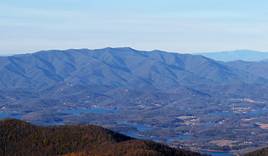
| I've long admired the Tusquitee Mtns from Brasstown Bald, Tray Mtn, Bell Knob, etc...they are the range just across the NC border past Hiawassee. They look very impressive and always wanted to get up there, so lets give it a shot.
We will start at the trailhead near the Bob Allison campground, at 3025' and jump on the Chunky Gal up to Tusquitee Bald. (The Chunky Gal trail starts near Deep Gap, close to Standing Indian mtn and ends up near Tusquitee Bald, so we will just be hiking one short section of it). The hike up is just 3.4 mi, so that means it gains about 700' per mile..so should be a fairly steady climb. Once we reach Tusquitee Bald, we will admire the views (if there are any) and there will be some other peaks nearby Balds that we may check out as well.: Weatherman, Potrock and Matlock. Again, I don't know how "bald" they really are and what kind of views we'll get up there. But they are all are within a mile or two away along the Fires Creek Rim Trail so we should be able to visit at least a couple of them. It's tough to estimate total distance but I would say just be sure you can do 10-15 miles and over 3000' of total ascent...solid D5 numbers there. So it should be a challenging hike but also a rewarding and satisfying one. | |||||||
| |||||||
| How to Get There: | |||||||
| Event Directions: | given via email if meeting at event | ||||||
| Carpool to Event Distance (round trip): | 210Mile(s) | ||||||
| Carpool Departure Time: | 7:15 am | ||||||
| Carpool Location: | Log in for location | ||||||
| Carpool Directions: | Log in for directions | ||||||
| Carpool Cost: | Estimated cost per vehicle for this event is $84.00 using a reimbursement rate guideline of $0.400 per mile. The total amount should be divided by the number of people in the vehicle, including the driver. This is a guideline, not a rule, for drivers but the cost should not be higher unless there are extenuating circumstances. | ||||||
| Notes: | |||||||
|
PLEASE NOTE: If you have not very recently completed some AOC D5 hikes, we will be contacting you to determine if this is the right hike for you. * We encourage all members to follow our Etiquette Guidelines while participating in AOC events. | |||||||
Cancellation/Partial Attendance: Please review the AOC cancellation policy. | |||||||
 Calendar of Events
 Event Places