 Print-Friendly Version Print-Friendly Version
|
|
Arkaquah & Raven Cliff -- Flowers, vistas, and falls | |||||||
| The Basics: | |||||||
| Event Type: | Hike | ||||||
| Event Location: |
Chattahoochee National Forest


| ||||||
| Date(s) & Time: | Sat, May 21 2011 6:15 am >> Sat, May 21 2011 8:06 pm (Carpool Departure: 6:30 am *log in for location*) | ||||||
| Registration Opens: | Mon, Apr 4 2011 9:00 pm | ||||||
| Registration Cut Off: | Thu, May 19 2011 11:00 pm | ||||||
| Event Duration: | 13 Hours 51 Minutes | ||||||
| Difficulty Rating: | D5: Difficult | ||||||
| Pace: | Fast | ||||||
| Trip Leader(s): | Tanja B Amy  Email Trip Leader(s) Email Trip Leader(s)
You must be logged in to get the Trip Leader contact information. | ||||||
| Member Cost: | None | ||||||
| Participant Info: | |||||||
| Who's Invited: | Members Only, 21 And Older Only | ||||||
| Maximum Group Size: | 16 | ||||||
| Minimum Group Size: | 4 | ||||||
| Number Registered So Far: | 15 / 0 (To see who's signed up, log in to the Member Area) | ||||||
| Are Dogs Permitted: | Yes | ||||||
| Itinerary: | |||||||
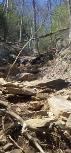
| This is an early-bird day-long enjoyment of North Georgia that is not for
the timid. This is a long, difficult 17-mile day, combining what is arguably
Georgia's toughest trail and a much easier (but not short) trail in the hot
afternoon. For the sake of your fellow AOC participants, please do not
sign up unless you are in good enough physical condition to complete
the hike. We'll leave the carpool location with the rising sun and get onto the trail ~8:30 so the weather is still relatively cool and refreshing for that formidable early wake-up climb. The Arkaquah trail is a beautiful long ridge walk up to Brasstown Bald, the highest peak in Georgia. The trail is approximately 12 miles round trip. It starts at Trackrock Gap (2280 ft) and immediately climbs 1500 ft to Roost Ride in the first 1.7 miles. Following the ridge eastwards, we slowly climb the remaining 4.4 miles to Brasstown Bald (mile 6.1; 4738 ft). There are several vistas and quite likely a variety of flowers blooming along the trail. We'll eat an early lunch on top of Brasstown Bald while enjoying the view, then head back the way we came. It will still be fairly early afternoon when we get back down, with plenty of daylight left (sunset is ~8:30). We wouldn't want to waste that, would we? Arkaquah has the vistas and the flowers, but it's missing impressive waterfalls ... and it just so happens that Raven Cliff Falls is not terribly far off our return trip course. A quick 30-minute drive takes us to the Raven Cliff Falls trailhead, which we would nominally reach ~3pm. The trail to the falls is a moderate hike along a shaded creek which would add 5 miles and 700ft elevation gain to our day (plus 500' for climbing to the top of the falls themselves), but above all we get to spend some time hanging along the creek, cooling our feet, and listening to a roaring waterfall before the late hour turns our heads homewards. TBD: We'll likely stop in Cleveland on the way home to grab a bite. Distance: 17 miles Elevation Gain: 4500 ft Please Note: | |||||||
| |||||||
| How to Get There: | |||||||
| Event Directions: | Directions to Track Rock Gap (Arkaquah Trailhead) Take GA- 400 (US-19) North. Continue on US-19, through its twists and turns, through Dahlonega and past Vogel State Park. 2.4 miles after Vogel State Park, turn right onto GA-180. Follow GA-180 for 2.4 miles, then turn LEFT onto Town Creek School Rd. After another 2.2 miles, turn RIGHT onto Trackrock Church Rd. 3.2 miles later, turn RIGHT again onto Trackrock Gap Rd. The trailhead is a small gravel parking lot a mile down the road on your left. | ||||||
| Carpool to Event Distance (round trip): | 164Mile(s) | ||||||
| Carpool Departure Time: | 6:30 am | ||||||
| Carpool Location: | Log in for location | ||||||
| Carpool Directions: | Log in for directions | ||||||
| Carpool Cost: | Estimated cost per vehicle for this event is $65.60 using a reimbursement rate guideline of $0.400 per mile. The total amount should be divided by the number of people in the vehicle, including the driver. This is a guideline, not a rule, for drivers but the cost should not be higher unless there are extenuating circumstances. | ||||||
| Notes: | |||||||
|
* We encourage all members to follow our Etiquette Guidelines while participating in AOC events. | |||||||
Cancellation/Partial Attendance: Please review the AOC cancellation policy. | |||||||
 Calendar of Events
 Event Places