 Print-Friendly Version Print-Friendly Version
|
|
Black Rock Mountain State Park - 3 Trails | |||||||
| The Basics: | |||||||
| Event Type: | Hike | ||||||
| Event Location: |
NE corner of GA via I-985 & US-441


| ||||||
| Date(s) & Time: | Sun, May 22 2011 8:00 am >> Sun, May 22 2011 6:00 pm (Carpool Departure: 8:00 am *log in for location*) | ||||||
| Registration Opens: | Wed, Apr 20 2011 10:00 pm | ||||||
| Registration Cut Off: | Fri, May 20 2011 4:00 pm | ||||||
| Event Duration: | 10 Hours | ||||||
| Difficulty Rating: | D5: Difficult | ||||||
| Pace: | Moderate | ||||||
| Trip Leader(s): | Marcus Email Trip Leader(s) Email Trip Leader(s)
You must be logged in to get the Trip Leader contact information. | ||||||
| Member Cost: | None | ||||||
| Participant Info: | |||||||
| Who's Invited: | Members Only, 21 And Older Only | ||||||
| Maximum Group Size: | 12 | ||||||
| Minimum Group Size: | 2 | ||||||
| Number Registered So Far: | 10 / 0 (To see who's signed up, log in to the Member Area) | ||||||
| Are Dogs Permitted: | No | ||||||
| Itinerary: | |||||||
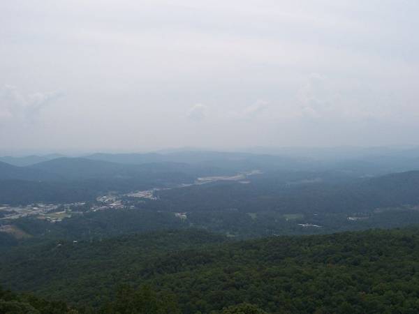
| NOTE: I've chosen to change the date of this event to May 22nd because of likely traffic congestion in the Mountain City area on the originally posted date, May 15th. The huge annual "Warrior Dash" adventure race will be held near the State Park on the 15th. This hike was led by Clay White earlier this year, but unfortunately it was raining that day, so let's try it again and hope for better weather. Thanks to Clay for his initial write-up which I've edited to include some other information. Located in the Blue Ridge Mountains just north of Clayton, GA, Black Rock Mountain is Georgia's highest State Park, with much of its rugged terrain at 3000' above sea level or higher. On clear days hikers enjoy 80-mile vistas, including three states! Several overlooks offer beautiful views of the Southern Appalachian mountains and the valleys below. In other places the trails encircle lakes and meander along cascading streams with occasional small waterfalls. Our plan is to take a moderately fast pace and to hike all four three trails in the Park, totaling about 11 miles, in this order:
2) Tennessee Rock Trail: This is a 2.2-mile loop, described as easy, but with great views. 3) James E. Edmonds Backcountry Trail: This is a moderate to strenuous 7.2-mile loop, which includes a walk beside the meandering Taylor Creek and a fabulous view of the Little Tennessee Valley from a rocky outcrop atop Lookoff Mountain. The outcrop's granite surfaces can be surprisingly slippery, so beware!—the cliff drops several hundred feet straight down. 4) Black Rock Lake Trail: An easy 0.85-mile loop around a scenic 17-acre lake. This will be a small detour off the James E. Edmonds trail. Free Downloadable Trail Map! Use the following link for the State Park's beautiful color topo map that clearly shows all of the trails. (Free copies of these nice maps are available now in most of the GA State Park Visitor Centers upon request, so don't forget to stop by and ask for one!) | |||||||
| |||||||
| How to Get There: | |||||||
| Event Directions: | We prefer that all hikers meet at the Carpool (directions below) where precise Directions to the Trailhead will be given out and discussed. For those who wish to use GPS navigation (or Google.com/maps for mapping your approach) the State Park address is: 3085 Black Rock Mountain Parkway Mountain City , GA 30562 The approximate GPS coordinates at the Park entrance are: N 34.917240, W 083.403730 | ||||||
| Carpool to Event Distance (round trip): | 182Mile(s) | ||||||
| Carpool Departure Time: | 8:00 am | ||||||
| Carpool Location: | Log in for location | ||||||
| Carpool Directions: | Log in for directions | ||||||
| Carpool Cost: | Estimated cost per vehicle for this event is $72.80 using a reimbursement rate guideline of $0.400 per mile. The total amount should be divided by the number of people in the vehicle, including the driver. This is a guideline, not a rule, for drivers but the cost should not be higher unless there are extenuating circumstances. | ||||||
| Notes: | |||||||
|
- I'll be out of town from 05/06 to 05/14, probably without an easy access to phone or internet. I'll manage the wait lists and answer your e-mails when I get back. * We encourage all members to follow our Etiquette Guidelines while participating in AOC events. | |||||||
| Cost Includes: | No charge of course for the hike, but please bring Cash for your share of the $5 State Park Parking Fee (unless you display a valid GA-DNR annual pass) and for your fair share of carpooling expenses. | ||||||
Cancellation/Partial Attendance: Please review the AOC cancellation policy. *Note: A little rain won't kill us, but I may postpone or cancel events that I lead if the weather is foul enough (on a case-by-case basis). | |||||||
 Calendar of Events
 Event Places