 Print-Friendly Version Print-Friendly Version
|
|
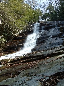
Day Hike to Panther Creek Falls (in the Cohutta Wilderness) | |||||||
| The Basics: | |||||||
| Event Type: | Hike | ||||||
| Event Location: | Cohutta Wilderness | ||||||
| Date(s) & Time: | Sun, May 22 2011 7:30 am >> Sun, May 22 2011 6:00 pm (Carpool Departure: 7:30 am *log in for location*) | ||||||
| Registration Opens: | Mon, Apr 18 2011 9:00 pm | ||||||
| Registration Cut Off: | Fri, May 20 2011 6:00 pm | ||||||
| Event Duration: | 10 Hours 30 Minutes | ||||||
| Difficulty Rating: | D4: Moderate to Difficult | ||||||
| Pace: | Moderate | ||||||
| Trip Leader(s): | Paula Schubert Christopher Bolton  Email Trip Leader(s) Email Trip Leader(s)
You must be logged in to get the Trip Leader contact information. | ||||||
| Member Cost: | None | ||||||
| Participant Info: | |||||||
| Who's Invited: | Members Only, 21 And Older Only | ||||||
| Maximum Group Size: | 12 | ||||||
| Minimum Group Size: | 4 | ||||||
| Number Registered So Far: | 10 / 0 (To see who's signed up, log in to the Member Area) | ||||||
| Are Dogs Permitted: | No | ||||||
| Itinerary: | |||||||
Come join us for a dayhike in the the beautiful Cohutta Wilderness. Our hike will begin at the southern end of the East Cowpen trail otherwise known as Three Forks Mountain (3500 Ft). At 2.3 miles, we’ll take the Panther Creek trail, which is a 3.4 mile interior trail in the Cohutta Wilderness. This trail has some very rugged, downhill rocky sections more towards the falls, which is better described as a boulder field. Once to Panther Creek falls, we'll break for lunch, take time to explore and take pictures. Our journey will continue downward past the falls and follow Panther Creek downstream, which ends at the Conasauga River. We'll ford the Conasauga River and head upstream where we cross the river 18 more times. This eventually leads us away from the river only to be meandering through a wandering maze of rivulets, which are the headwaters to the Conasauga River. The last .2 miles ascends very sharply out to Betty’s Gap where a couple of our vehicles will be waiting for us. This hike requires an approx. 3 mile car shuttle approx., so we'll need 2 confirmed drivers in addition to the trip leader who will be driving. We'll be keeping a moderate pace (a minimum of 2.5 mph). Hiking mileage: approx. 10.6 mile day hike Hiking poles will be required for river crossings. You need to have previous D4 hiking experience for this hike. River crossings can add another layer of difficulty, so you must be in good physial shape. | |||||||
| |||||||
| How to Get There: | |||||||
| Event Directions: | Will be given out at carpool. | ||||||
| Carpool to Event Distance (round trip): | 180Mile(s) | ||||||
| Carpool Departure Time: | 7:30 am | ||||||
| Carpool Location: | Log in for location | ||||||
| Carpool Directions: | Log in for directions | ||||||
| Carpool Cost: | Estimated cost per vehicle for this event is $72.00 using a reimbursement rate guideline of $0.400 per mile. The total amount should be divided by the number of people in the vehicle, including the driver. This is a guideline, not a rule, for drivers but the cost should not be higher unless there are extenuating circumstances. | ||||||
| Notes: | |||||||
|
Are Dogs Permitted? No, because of river crossings. Will this event occur rain or shine? No, not in severe weather. * We encourage all members to follow our Etiquette Guidelines while participating in AOC events. | |||||||
| Cost Includes: | Please remember to bring cash to share gas expense with carpool drivers. | ||||||
Cancellation/Partial Attendance: Please review the AOC cancellation policy. | |||||||
 Calendar of Events
 Event Places