 Print-Friendly Version Print-Friendly Version
|
Lake Lanier Hike and Swim | |||||||
| The Basics: | |||||||
| Event Type: | Hike | ||||||
| Event Location: |
Buford, GA


| ||||||
| Date(s) & Time: | Sat, Aug 6 2011 9:00 am >> Sat, Aug 6 2011 1:30 pm | ||||||
| Registration Opens: | Wed, Aug 3 2011 8:51 am | ||||||
| Registration Cut Off: | Fri, Aug 5 2011 8:00 pm | ||||||
| Event Duration: | Per Itinerary | ||||||
| Difficulty Rating: | D2: Easy to Moderate | ||||||
| Distance: | 6 Miles | ||||||
| Pace: | Moderate | ||||||
| Trip Leader(s): | Tony C Email Trip Leader(s) Email Trip Leader(s)
You must be logged in to get the Trip Leader contact information. | ||||||
| Member Cost: | None | ||||||
| Participant Info: | |||||||
| Who's Invited: | Members Only, 21 And Older Only | ||||||
| Maximum Group Size: | 16 | ||||||
| Minimum Group Size: | 4 | ||||||
| Number Registered So Far: | 16 / 0 (To see who's signed up, log in to the Member Area) | ||||||
| Are Dogs Permitted: | No | ||||||
| Itinerary: | |||||||
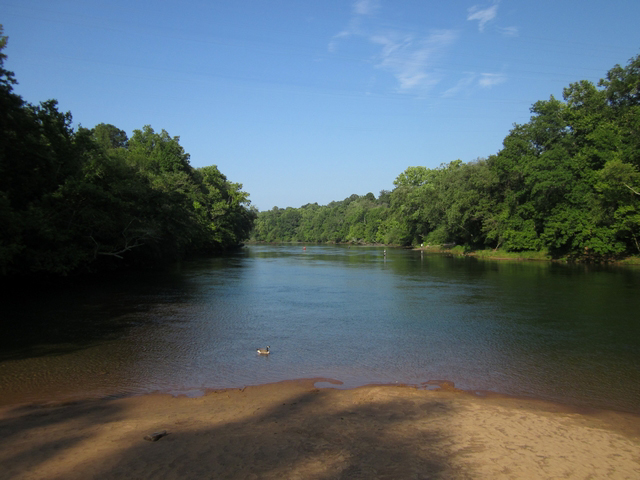
| Ok I am borrowing this idea from Trip Leader extraordinaire Richard Zalik. He has led this one a couple of times and it's a great little hike to do in the hot weather. We will start out on the 4mi Laurel Ridge Trail. We will leave the trail and take a side trip down to the bottom of Buford Dam. and over to the Chatt NRA Bowman's Island area. We will walk down there for a little while...not very far, but just the start the trail to add some extra variety to the hike. Then we will turn around and retrace our steps back to where we left the Laurel Ridge trail and continue on it. At about 4 1/2 mi, we will come to the little beach. area on Lake Lanier. We will take a long break there and we can wade into the water and swim. I was there a few days ago and it is very comfortable..cool and refreshing...not cold at all. There is a restroom there too for you to change in and out of your swimsuit if you would like to. Then we will get back on the trail for the last mile or so back to the cars. We should be finished by about 1:30 pm at the latest and probably a good bit earlier than that. There is a moderate amount of elevation change on this one..probably about 500-600 feet along the entire route, so it is a tougher D2. You could maybe call it an easy D3, but we won't be going at a fast pace, so keeping it a D2 this time. | |||||||
| |||||||
| How to Get There: | |||||||
| Event Directions: | From I85, head north and take the I 985 exit. Continue a little under 4 miles on I 985 until Exit 4. At the top of the ramp take a left onto SR 20. Proceed about 5.5 miles on SR 20 and take a right onto Suwanee Dam Road, which dead ends after 2.2 miles when it reaches Buford Dam Road. Take a left onto Buford Dam Road, and proceed 1 mile. The Lower Overlook parking will be on your right. If you reach Buford Dam you have gone too far. | ||||||
| Notes: | |||||||
|
* We encourage all members to follow our Etiquette Guidelines while participating in AOC events. | |||||||
Cancellation/Partial Attendance: Please review the AOC cancellation policy. | |||||||
 Calendar of Events
 Event Places