 Print-Friendly Version Print-Friendly Version
|
Panther Creek Trail / Falls (Hike / Swim) | |||||||
| The Basics: | |||||||
| Event Type: | Hike | ||||||
| Event Location: |
Turnerville, GA


| ||||||
| Date(s) & Time: | Sat, Sep 10 2011 10:00 am >> Sat, Sep 10 2011 3:30 pm (Carpool Departure: 8:45 am *log in for location*) | ||||||
| Registration Opens: | Fri, Sep 2 2011 9:10 am | ||||||
| Registration Cut Off: | Thu, Sep 8 2011 9:30 pm | ||||||
| Event Duration: | 5 Hours 30 Minutes | ||||||
| Difficulty Rating: | D5: Difficult | ||||||
| Distance: | 12 Miles | ||||||
| Pace: | Moderate | ||||||
| Trip Leader(s): | Mark Sam L  Email Trip Leader(s) Email Trip Leader(s)
You must be logged in to get the Trip Leader contact information. | ||||||
| Member Cost: | None | ||||||
| Participant Info: | |||||||
| Who's Invited: | Members Only, 21 And Older Only | ||||||
| Maximum Group Size: | 14 | ||||||
| Minimum Group Size: | 4 | ||||||
| Number Registered So Far: | 16 / 0 (To see who's signed up, log in to the Member Area) | ||||||
| Are Dogs Permitted: | No | ||||||
| Itinerary: | |||||||
| Summary:
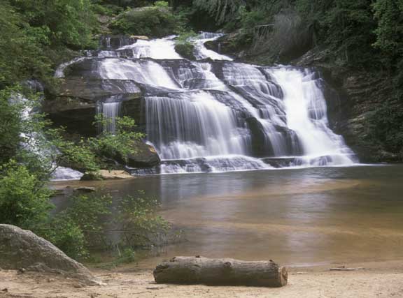
This 11-mile round-trip hike starts at Panther Creek Recreation Area just north of Turnerville, Georgia on US 441. From the recreation area, the blue blazed trail progresses east to the magnificent Panther Creek Falls. The steeply sloping path descends to the bottom of the falls, and then continues a few more miles to Davidson Creek. We will then retrace our path approximately 6 miles back to the trailhead. Details: From the parking area we pass a number of shoals along the creek and after approximately 3.5 miles we will arrive at Panther Creek Falls where we will take a break long enough to enjoy lunch. After our lunch break we will continue along the trail down to the trail's end at Davidson Creek. This part of the trail below the falls has some very steep, rocky climbs, with the possibility of some fallen trees which we may have to go around or climb over. However, this part of the trail is supposed to be very interesting and the forest service has given it a special designation of "Panther Creek Botanical Area," as it supports unique flora and fauna. This area of the forest also contains larger, more mature, forest species of Oak, Tuliptree, Basswood, and American Beech. On the return journey we will again stop at the Panther Creek falls and take a break for a dip in the pool at the base of the falls. This hike is rated a D5 for distance and some potentially difficult steep rocky climbs and fallen trees, so hikers should be in sufficient physical shape. There is a very steep ascent of approximately 650' between Davidson Creek and the bottom of the falls. In this one mile section, it will be roughly the equivalent of a Stone Mountain ascent. It is anticipated that we will cover at least 2000' of total ascent on this trail, and we may do a few brief side trails for additional viewing opportunities, which could potentially add another mile to the hike. As such, it is strongly recommended that you have recent D4 or D5 hiking experience. Since we will be swimming in the pool below the falls, you may want to wear a bathing suit under your hiking clothes, or bring one in your backpack. Disclosure: Your TL's, who enjoy exploring new places as much as you do, have not hiked this trail. By all accounts this trail is well marked, we have studied the guide books / maps, and will have these materials in hand as well as a GPS with a previous track log. Nevertheless, please have a sense of adventure and be in sufficient physical condition to hike a little extra mileage if we should miss a turn somewhere. There is a $3 fee to park at the Panther Creek Recreation Area. Drinking fountains and a restroom are supposedly located at the recreation area near the trail head. | |||||||
| |||||||
| How to Get There: | |||||||
| Event Directions: | Travel north on I-85 and then exit left on I-985 north. Continue traveling north on I-985 which will become route US 23. Continue north on US 23 and just just past Turnerville, turn left on Travis Smith Rd. Travel approximately 0.1 mile to the intersection of US 441 Historical. Turn right on US 441 Historical and travel approximately 0.8 miles to the Panther Creek Recreation area parking lot on your left. | ||||||
| Carpool to Event Distance (round trip): | 150Mile(s) | ||||||
| Carpool Departure Time: | 8:45 am | ||||||
| Carpool Location: | Log in for location | ||||||
| Carpool Directions: | Log in for directions | ||||||
| Carpool Cost: | Estimated cost per vehicle for this event is $60.00 using a reimbursement rate guideline of $0.400 per mile. The total amount should be divided by the number of people in the vehicle, including the driver. This is a guideline, not a rule, for drivers but the cost should not be higher unless there are extenuating circumstances. | ||||||
| Notes: | |||||||
|
* We encourage all members to follow our Etiquette Guidelines while participating in AOC events. | |||||||
Cancellation/Partial Attendance: Please review the AOC cancellation policy. | |||||||
 Calendar of Events
 Event Places