 Print-Friendly Version Print-Friendly Version
|
|
Rich Mountain Wilderness Cartecay River Swim | |||||||
| The Basics: | |||||||
| Event Type: | Hike | ||||||
| Event Location: |
Rich Mountain Wilderness Area/Cartecay River


| ||||||
| Date(s) & Time: | Sun, Sep 4 2011 9:00 am >> Sun, Sep 4 2011 5:00 pm (Carpool Departure: 9:15 am *log in for location*) | ||||||
| Registration Opens: | Mon, Aug 29 2011 4:49 am | ||||||
| Registration Cut Off: | Sun, Sep 4 2011 9:00 am | ||||||
| Event Duration: | 8 Hours | ||||||
| Difficulty Rating: | D4: Moderate to Difficult | ||||||
| Distance: | 7 Miles | ||||||
| Pace: | Fast | ||||||
| Trip Leader(s): | Grant Brown Email Trip Leader(s) Email Trip Leader(s)
You must be logged in to get the Trip Leader contact information. | ||||||
| Member Cost: | None | ||||||
| Participant Info: | |||||||
| Who's Invited: | Members Only, 21 And Older Only | ||||||
| Maximum Group Size: | 20 | ||||||
| Minimum Group Size: | 3 | ||||||
| Number Registered So Far: | 19 / 0 (To see who's signed up, log in to the Member Area) | ||||||
| Are Dogs Permitted: | Yes | ||||||
| Itinerary: | |||||||
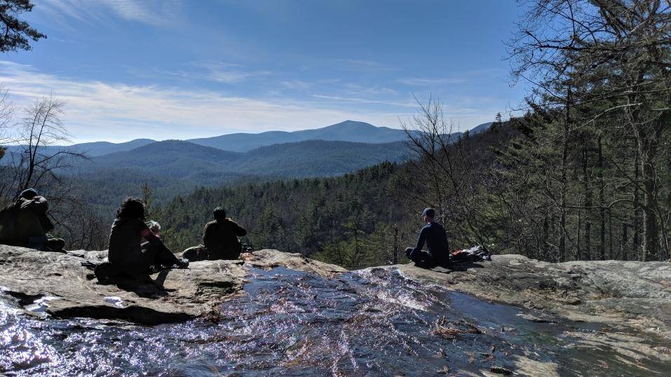
This beautiful spot in North Georgia is just about an hours drive from Atlanta. I hope you can make it for this fun, but fast hike.
We did this back in June and had a blast. See photos and video. This is a loop trail that starts outside of East Ellijay in the Rich Mountain Wilderness Cartecay River Tract, and winds down to the water. We will be hiking around some of the loops and hills for about five miles or so leading down to the river spot where we will hang out on the rocks for a picnic lunch, some sun, and a swim. It is fun to take off down the river feet first and do some body surfing. There is also an excellent jumping rock. Once we've had enough - probably around 2 and 1/2 hours total - we'll head back a different way than we came at first and will get in another fast paced two miles back to the cars.
The hiking pace will be fairly brisk at around 3.5 mph.
Total hike and lunch time is approximately 4.5 hours.
Total drive time is approximately 2.5 hours. Starbucks on the left on the way back : )
Best guess is that we'll be back at Chastain between 4 and 5.
Here is a trail map with written driving directions. | |||||||
| |||||||
| How to Get There: | |||||||
| Event Directions: |
Directions to the triaihead. However, please note at the end, keep driving straight for about 100 yards on a gravel road that is not on Google maps. | ||||||
| Carpool to Event Distance (round trip): | 118Mile(s) | ||||||
| Carpool Departure Time: | 9:15 am | ||||||
| Carpool Location: | Log in for location | ||||||
| Carpool Directions: | Log in for directions | ||||||
| Carpool Cost: | Estimated cost per vehicle for this event is $47.20 using a reimbursement rate guideline of $0.400 per mile. The total amount should be divided by the number of people in the vehicle, including the driver. This is a guideline, not a rule, for drivers but the cost should not be higher unless there are extenuating circumstances. | ||||||
| Notes: | |||||||
|
* We encourage all members to follow our Etiquette Guidelines while participating in AOC events. | |||||||
Cancellation/Partial Attendance: Please review the AOC cancellation policy. | |||||||
 Calendar of Events
 Event Places