 Print-Friendly Version Print-Friendly Version
|
|
Cohutta Wilderness backpacking - Rice Camp Trail | |||||||
| The Basics: | |||||||
| Event Type: | Backpacking | ||||||
| Event Location: | Rice Camp Trail trail head | ||||||
| Date(s) & Time: | Sat, Nov 5 2011 7:30 am >> Sun, Nov 6 2011 5:30 pm (Carpool Departure: 7:30 am *log in for location*) | ||||||
| Registration Opens: | Mon, Oct 17 2011 8:30 pm | ||||||
| Registration Cut Off: | Fri, Nov 4 2011 12:00 pm | ||||||
| Event Duration: | 1 Days 11 Hours | ||||||
| Difficulty Rating: | D4: Moderate to Difficult | ||||||
| Distance: | 10 Miles | ||||||
| Pace: | Moderate | ||||||
| Trip Leader(s): | Kristi Email Trip Leader(s) Email Trip Leader(s)
You must be logged in to get the Trip Leader contact information. | ||||||
| Member Cost: | None | ||||||
| Participant Info: | |||||||
| Who's Invited: | Members Only, 21 And Older Only | ||||||
| Maximum Group Size: | 8 | ||||||
| Minimum Group Size: | 3 | ||||||
| Number Registered So Far: | 8 / 0 (To see who's signed up, log in to the Member Area) | ||||||
| Are Dogs Permitted: | No | ||||||
| Itinerary: | |||||||
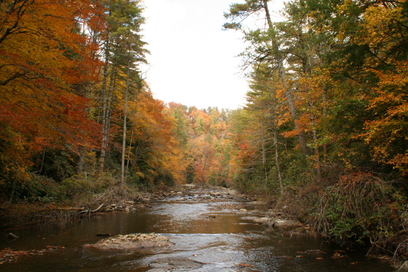
Several years ago, I went to this location on the first weekend in November and the autumn colors were at their peak; the photo was taken then. I'm hoping for the same. It's a great place to photograph colorful trees bordering a wild mountain river and enjoy with others a wilderness experience -- all without hiking very far. It is appropriate for those fairly new to backpacking as the mileage and terrain are moderate. This is a small campsite, hence the maximum group number is low.
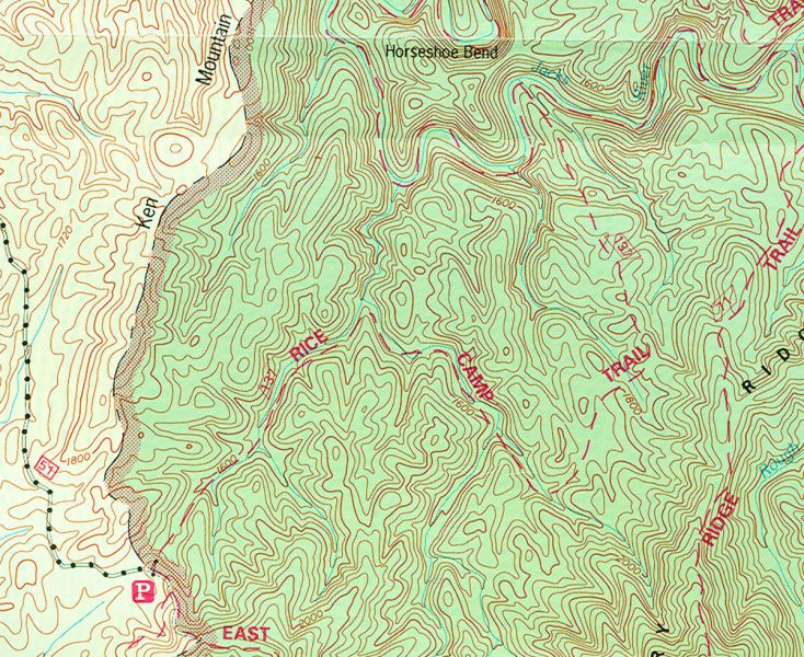
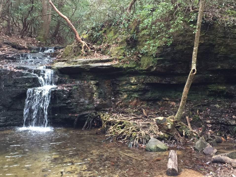
Rice Camp Trail follows the clear, cold, often sliding water of small streams for the first half of its length. Almost from its beginning at 1,740 feet, the wide and always wet trail parallels a tributary of Rice Camp Branch. After crossing this headwater rivulet for the third time at mile 1.1, the trail trades streams and follows Rice Camp Branch. After nine Rice Camp Branch crossings and 1.9 miles of nearly level terrain, the path turns left away from the stream and ascends moderate and more gradual upgrades on an old roadbed until it opens into a white oak flat, once the site of a logging camp and sawmill. At mile 2.7 the trail makes a short, sharp drop to a muddy rivulet. Look for the smooth, light-gray bark of the last few large beech trees still standing beside the small stream. These crossings typically have low levels of water, not requiring a change from your regular hiking boots. The remainder of Rice Camp traverses a succession of low, dry ridges through a predominantly oak- pine forest. The resulting ups and downs are easy or moderate. The land beside the trail often slopes away gradually on small spur ridges or falls away suddenly into moist ravines on either side of the ridge top, where there are some very steep but short sections. The wilderness path descends through a belt of rosebay rhododendron and eastern hemlock to 1,350 feet, where it ends at the orange-blazed Jacks River Trail above a normally shallow tributary. Exploratory option: (dependant on water crossing and time availability after gathering wood, eating lunch and setting up camp). Jacks River Falls is one ford and 1.2 miles to the right, east and upstream, on a very scenic portion of the Jacks River Trail. Bring some river shoes for this crossing; it will likely be knee high. If the day is sunny and in the mid 50's or above, we should be fine making this crossing. The next morning, by 10:30am, we'll hike the 3.9 miles back the way we came. I estimate that we'll be back at the Park-n-Ride in Kennesaw no later than 5pm, give or take. Be forewarned, if you rush back to the parking lot, there will be a strong hiker sweeping behind the slowest hiker, and there will be time designated for the sweeper to stretch before driving home. That said, please only attempt this trip if you're in good physical condition, and can backpack in the mountains at a 2mph pace. If you want to race, or feel that pump, that's fine, but don't go past forks without waiting, and don't expect the sweep to push the slower hikers beyond their capacity. If you feel the need, do some push-ups or hand stands and you'll be fine. And if you don't know yoga, I highly recommend it. Over the years, there has been many bear sightings in the Cohutta's, so be prepared to protect your food with a way to hang it bagged in a tree. Note -- Thank you Michael Johnson for some of the details that I have used from a previous trip description.
| |||||||
| |||||||
| How to Get There: | |||||||
| Event Directions: | From the GA 52-US 411 intersection in
Chatsworth, travel US 411 North approximately 13.4 miles, past Eton toward Tennga, to the community
of Cisco. In Cisco, turn right onto the paved road immediately before the Cisco Baptist Church, also on the right. Once part
of GA 2, this road is now known as Old GA 2. This road is also FS 16.
Continue on FS 16 (the pavement ends; stay to the right at the fork; pass
Hopewell Church; cross the Conasauga River) for approximately 7.9
miles, then turn right onto FS 51. Proceed about 4.8 miles} making two fords. The fords may require a utility vehicle in wet weather. You will find the Rice Camp trailhead, bulletin board, and parking area on the left. As you approach, Rice Camp Trail is to the left and East Cowpen Trail is straight ahead into the wilderness.
| ||||||
| Carpool to Event Distance (round trip): | 180Mile(s) | ||||||
| Carpool Departure Time: | 7:30 am | ||||||
| Carpool Location: | Log in for location | ||||||
| Carpool Directions: | Log in for directions | ||||||
| Carpool Cost: | Estimated cost per vehicle for this event is $72.00 using a reimbursement rate guideline of $0.400 per mile. The total amount should be divided by the number of people in the vehicle, including the driver. This is a guideline, not a rule, for drivers but the cost should not be higher unless there are extenuating circumstances. | ||||||
| Notes: | |||||||
|
If the weather forecast prediction is for 60% chance of rain or higher for the entire weekend, this trip will likely be cancelled. However I've backpacked the Cohuttas with high chances of rain, and had sunny days. * We encourage all members to follow our Etiquette Guidelines while participating in AOC events. | |||||||
Cancellation/Partial Attendance: Please review the AOC cancellation policy. | |||||||
 Calendar of Events
 Event Places