 Print-Friendly Version Print-Friendly Version
|
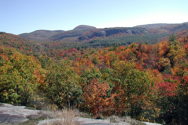
Panthertown Valley | |||||||
| The Basics: | |||||||
| Event Type: | Backpacking | ||||||
| Event Location: |
near Cashiers, NC


| ||||||
| Date(s) & Time: | Sat, Oct 22 2011 11:00 am >> Sun, Oct 23 2011 7:00 pm (Carpool Departure: 8:00 am *log in for location*) | ||||||
| Registration Opens: | Mon, Oct 10 2011 8:00 pm | ||||||
| Registration Cut Off: | Fri, Oct 21 2011 9:00 pm | ||||||
| Event Duration: | 1 Days 8 Hours | ||||||
| Difficulty Rating: | D4: Moderate to Difficult | ||||||
| Distance: | 15 Miles | ||||||
| Pace: | Moderate | ||||||
| Trip Leader(s): | Ralph Howard Ann  Email Trip Leader(s) Email Trip Leader(s)
You must be logged in to get the Trip Leader contact information. | ||||||
| Member Cost: | None | ||||||
| Participant Info: | |||||||
| Who's Invited: | Members Only, 21 And Older Only | ||||||
| Maximum Group Size: | 8 | ||||||
| Minimum Group Size: | 3 | ||||||
| Number Registered So Far: | 7 / 0 (To see who's signed up, log in to the Member Area) | ||||||
| Are Dogs Permitted: | No | ||||||
| Itinerary: | |||||||
|
Come join us for the weekend and enjoy the fall colors at one of our favorite destinations - Panthertown Valley, a/k/a/ Yosemite of the East. This is a beautiful area with plenty of streams, waterfalls and surrounding mountains with great vistas. The place is more "civilized" now that there are trail markers, but you can still count on some adventures off the beaten paths. The backpacking portion of the trip is relatively easy, about 1.5 miles gently downhill to our campsite near Tuckasegge river just past Sandbar Pool. We'll set up camp and get a quick bite to eat, then head out day hiking for the rest of the day, returning to camp for dinner, beverages, and fellowship around a campfire. Sunday we will do a little day hiking before we break camp and backpack out to our cars for the return home. Those who have been to Panthertown Valley with me before know that I like to seek out as many waterfalls as possible, often taking "user created trails" that involve some bushwhacking. Because of the fall colors this trip will focus more on the mountain vistas, but I will include some waterfalls. My plan for Saturday's day hike is to hike to the top of Cold Mountain since Ann has not been there before, which is about an about 8 mile round trip with a 1000' elevation gain. We'll stop and enjoy Warden's Falls and perhaps Jawbone Falls on the way to finding the Little Green Creek trail which will take us up the mountain. The trail is hard to find but I have found it before so I don't think we will have any trouble. This is not an official maintained trail, so be sure to wear long pants and expect to do moderate scrambling/bushwhacking. Sunday we will take a short hike to Schoolhouse Falls and up Little Green Mountain before heading back to break camp. Depending on the weather and how the group is feeling we can drop packs part way out for a quick side trip to Granny Burrell Falls, or drop our packs in our cars and take the 2 mile round trip up Blackrock Mountain from the parking area. | |||||||
| |||||||
| How to Get There: | |||||||
| Event Directions: | North on I-85 to exit 1 in SC, then north on Hwy 11 about 20 miles to Walhalla. Then north on Hwy 28 to Hwy 17 north to Cashiers. At the stoplight in Cashiers, take US 64 east for 2 miles to Cedar Creek Road (SR 1120) and take a left. Proceed on Cedar Creek Road for 2.3 miles to Breedlove Road (SR 1121) and turn right. Proceed onto Breedlove Road for 3.5 miles to the Forest Service gate and the Salt Rock Gap trailhead. | ||||||
| Carpool to Event Distance (round trip): | 260Mile(s) | ||||||
| Carpool Departure Time: | 8:00 am | ||||||
| Carpool Location: | Log in for location | ||||||
| Carpool Directions: | Log in for directions | ||||||
| Carpool Cost: | Estimated cost per vehicle for this event is $104.00 using a reimbursement rate guideline of $0.400 per mile. The total amount should be divided by the number of people in the vehicle, including the driver. This is a guideline, not a rule, for drivers but the cost should not be higher unless there are extenuating circumstances. | ||||||
| Notes: | |||||||
|
* We encourage all members to follow our Etiquette Guidelines while participating in AOC events. | |||||||
Cancellation/Partial Attendance: Please review the AOC cancellation policy. | |||||||
 Calendar of Events
 Event Places