 Print-Friendly Version Print-Friendly Version
|
|
Big Scaly Mountain Waterfall Loop | |||||||
| The Basics: | |||||||
| Event Type: | Hike | ||||||
| Event Location: | Big Scaly Mountain, NC | ||||||
| Date(s) & Time: | Sat, Dec 17 2011 10:00 am >> Sat, Dec 17 2011 4:00 pm (Carpool Departure: 7:45 am *log in for location*) | ||||||
| Registration Opens: | Wed, Dec 7 2011 10:00 pm | ||||||
| Registration Cut Off: | Fri, Dec 16 2011 10:00 pm | ||||||
| Event Duration: | 11 hours, including driving time, 13 if you go to dinner | ||||||
| Difficulty Rating: | D5: Difficult | ||||||
| Distance: | 11 Miles | ||||||
| Pace: | Moderate | ||||||
| Trip Leader(s): | Sam L John Weatherman  Email Trip Leader(s) Email Trip Leader(s)
You must be logged in to get the Trip Leader contact information. | ||||||
| Member Cost: | None | ||||||
| Participant Info: | |||||||
| Who's Invited: | Members Only, 21 And Older Only | ||||||
| Maximum Group Size: | 16 | ||||||
| Minimum Group Size: | 2 | ||||||
| Number Registered So Far: | 13 / 0 (To see who's signed up, log in to the Member Area) | ||||||
| Are Dogs Permitted: | Yes | ||||||
| Itinerary: | |||||||
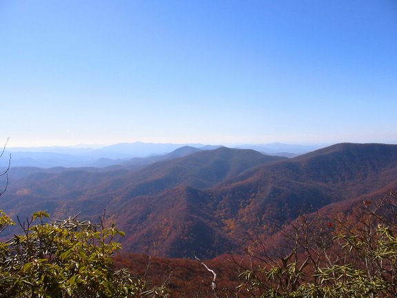
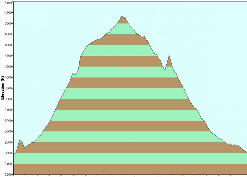
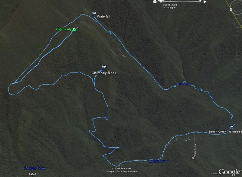
| Big Scaly is the mountain just below Standing Indian. This hike is a loop of about 11 miles and has about 2,500 feet of elevation gain. We will start by crossing Scaly Ridge and then go down to Beech Creek. We will follow the creek up Beech Creek Gorge and start up the switchbacks under the cliffs of Big Scaly Mountain. Then we will take a quarter mile side trail to view the 200 foot High Falls, and then come back to main trail. (We will have our lunch at High Falls.) Once we gain the top of the cliffs, we will go thru the high flat valley between Big Scaly Mountain and the main ridge that the AT is on to Case Knife Gap. Here we will take a left for a one mile side trail thru the virgin northern red oak ridge forest to the summit of Big Scaly Mountain at 5,060 feet for a very good view (see pic above). Then we backtrack back down to Case Knife Gap and go left to continue down Chimney Rock trail. There is an optional quarter mile side trail to the left to view Chimney Rock. You can climb Chimney Rock also if you want. Then we go down to end of the road we parked on. We will walk about a mile down this road to get back to the cars. For those of you who have done the Standing Indian hike, the back of our loop, where we go down, is coterminous with the front of that loop, where they go up. PLEASE NOTE: THIS IS NOT A BEGINNER HIKE *** You must be in good physical condition. You also need to be able to hike long distances and keep a moderate pace. This is a loop trail, so you will not be able to turn back once on the trail. *** That said, this is not a fast hike. The pace is moderate, and we plan to hike as a group. We will take several breaks to let slower people catch up. If you like to charge ahead of the main group, or if your legs get sore if you have to wait for people, please sign up for another event. We will be dining at La Cabana in Clayton, GA on the ride back for all who want to attend. Please coordinate dinner arrangements at the carpool with your driver to be sure that everyone in the car has the same plan. | |||||||
| |||||||
| How to Get There: | |||||||
| Event Directions: | Take I-85 N to I-985 N which turns into US 23/441 to Clayton GA. Pit stop at Burger King on right! (For bathrooms and "to go" only - we do not plan to sit down and eat.) Then go West on US 76 about eight miles. Turn right on Persimmon Rd, near the volunteer fire department and sign for Tallulah River Campgrounds. Continue about 4.2 miles to left at Tallulah River Rd. This road will turn to gravel after a mile or so and leads thru gorge to Tate City. Follow to NC state line. Trailhead parking will come up soon on the left. The road leading to the trailhead is gravel, so if you are uncomfortable driving at a reasonable speed on gravel please sign up to ride in someone else's car. | ||||||
| Carpool to Event Distance (round trip): | 220Mile(s) | ||||||
| Carpool Departure Time: | 7:45 am | ||||||
| Carpool Location: | Log in for location | ||||||
| Carpool Directions: | Log in for directions | ||||||
| Carpool Cost: | Estimated cost per vehicle for this event is $88.00 using a reimbursement rate guideline of $0.400 per mile. The total amount should be divided by the number of people in the vehicle, including the driver. This is a guideline, not a rule, for drivers but the cost should not be higher unless there are extenuating circumstances. | ||||||
| Notes: | |||||||
  * We encourage all members to follow our Etiquette Guidelines while participating in AOC events. | |||||||
Cancellation/Partial Attendance: Please review the AOC cancellation policy. | |||||||
 Calendar of Events
 Event Places